Area Overview for NW6 6QA
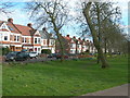
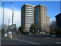
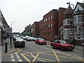
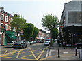
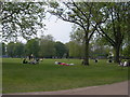
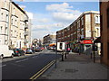
Photos of NW6 6QA


Area Information
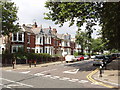
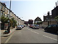
Living in NW6 6QA means calling home a specific residential cluster defined by its high density and urban proximity. This postcode covers an area of 7,772 square metres, supporting a community of 1,813 residents. The population density reaches 233,264 people per square kilometre, placing this location firmly within London's most concentrated residential zones. Daily life here revolves around close quarters and immediate access to nearby neighbourhoods rather than expansive gardens or significant land. You will find yourself surrounded by a tightly knit residential environment where neighbours are often just steps away. The area functions as a key residential node within the Kilburn and NW6 sector, offering a distinct urban experience for those seeking proximity to major transport hubs. There is no green belt or rural influence here; instead, every meter of this small property cluster is dedicated to housing within existing city fabric. Expect a busy atmosphere where local shops, transport links, and other residents create the primary rhythm of the day.
- Area Type
- Postcode
- Area Size
- 7772 m²
- Population
- 1813
- Population Density
- 16363 people/km²
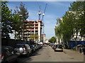
Homes in NW6 6QA exist primarily as flats within a high-density environment. The data confirms that flats are the predominant accommodation type, making this postcode a classic example of urban living where space is maximised vertically rather than horizontally. With only 39 per cent of the population owning their homes, the market focuses heavily on the rental sector and leasehold purchases. You are unlikely to find detached or semi-detached detached properties here; instead, you will encounter apartment blocks and purpose-built housing designed for communal living. The small physical size of the area, at just 7,772 square metres, restricts new build projects, meaning the housing stock is largely established. This concentration of flats creates a property environment where buyers and tenants are accustomed to shared corridors and communal facilities. For homebuyers, this means focusing on the condition of the block,管理服务 quality, and lease terms rather than garden size or garage space. The high density ensures steady demand for rental stock, which keeps the local housing market active despite the limited number of plots available.
House Prices in NW6 6QA
Showing 65 properties
| Address | Type | Beds | Baths | Last Sale Price | Last Sale Date | |
|---|---|---|---|---|---|---|
| 62 Victoria Road, London, NW6 6QA | Terraced | 4 | 2 | £1,625,000 | May 2022 | |
| 98 Victoria Road, London, NW6 6QA | Terraced | 6 | 2 | £1,500,000 | Apr 2021 | |
| 96 Victoria Road, London, NW6 6QA | house | 3 | 2 | £1,500,000 | Jun 2019 | |
| 88 Victoria Road, London, NW6 6QA | Terraced | - | - | £190,000 | Aug 1996 | |
| Flat 2, 82B Victoria Road, London, NW6 6QA | Maisonette | 2 | 1 | - | - | |
| Flat 3, 76 Victoria Road, London, NW6 6QA | Flat | 3 | 1 | - | - | |
| 56A Victoria Road, London, NW6 6QA | Flat | 1 | 1 | - | - | |
| Flat 4, 86 Victoria Road, London, NW6 6QA | Flat | 2 | 1 | - | - | |
| 104A Victoria Road, London, NW6 6QA | Flat | 3 | 1 | - | - | |
| Flat 2, 86 Victoria Road, London, NW6 6QA | Retail | 2 | 1 | - | - |
Energy Efficiency in NW6 6QA
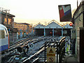
Your daily routine in NW6 6QA is supported by a dense network of nearby amenities within practical reach. Retail options are immediate, with Sainsburys Kilburn, Aldi Kilburn, and Co-op Queens offering all your grocery and daily shopping needs without a long walk. Five metro stations lie nearby, including Kilburn Park Station, Kilburn Station, and Maida Vale Station, ensuring swift access to central London and the Underground network. For those preferring trains, five rail hubs are accessible, featuring Queen's Park Station, Kilburn High Road Station, and Brondesbury Park Station. The area also includes a waterbus option with stops like Little Venice Waterbus Stop, London Zoo Waterbus Stop, and Camden Lock Waterbus, adding a scenic dimension to your commuting choices. Transport accessibility is comprehensive, with three major coach station locations including London Victoria Coach Station Arrivals, Victoria Coach Station, and Green Line Coach Station within a short travel radius. This concentration of transport links means you do not need to travel far for reliable public transit. The variety of options allows you to choose the mode of transport that fits your schedule, whether a train, tube, or waterbus, all while remaining within the Kilburn vicinity.
Amenities
Schools
| Rank | School | Type | Entry gender | Ages |
|---|
Explore more schools in this area
Go to Schools tabDemographics
The community in NW6 6QA reflects a mature cross-section of London life, anchored by a median age of 47 years. The most common age range for residents falls between 30 and 64 years, indicating a neighbourhood populated largely by adults in their productive years rather than families with young children or retirees seeking quiet retirement villages. Home ownership stands at 39 per cent, meaning the majority of residents are tenants renting their property or their family home. This figure suggests a market driven by private sector rentals and leasehold arrangements rather than freehold ownership. The primary accommodation type found within this postcode is flats, which aligns perfectly with the high density figure of over 233,000 people per square kilometre. Ethnic diversity in the area is predominantly White, though this does not preclude a multicultural mix typical of the wider Kilburn district. The demographic profile paints a picture of established households who value their independence and proximity to amenities, even if they do not sit in the land of a traditional detached house.
Household Size
Accommodation Type
Tenure
Ethnic Group
Religion
Household Composition
Age
Household Deprivation
NS-SEC
Explore more demographic insights in this area
Go to Demographics tabPlanning
Planning Constraints
- Flood RiskPremium
- Ramsar Wetland SitesPremium
- Area of Outstanding Natural BeautyPremium
- Protected Nature ReservePremium
- Protected WoodlandPremium