Area Overview for NW6 2AU
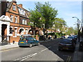
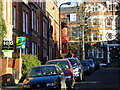
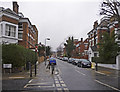
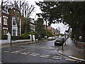
Photos of NW6 2AU

Area Information
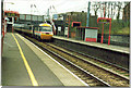
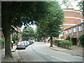
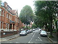
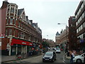
The postcode area NW6 2AU defines a specific residential cluster covering just 3929 square metres. This compact footprint houses a population of 1469 residents, creating a densely populated environment with over 373,890 people per square kilometre. Living in NW6 2AU means navigating a tightly knit neighbourhood where every street is close to the next. The area functions as a small-scale cluster within the wider London network, offering immediate proximity to major transport hubs. You will find yourself positioned right near West Hampstead Railway Station and Kilburn Station, which serve as primary gateways to the rest of the capital. Daily life here is characterised by rapid access to retail and leisure facilities, yet the sheer population density means shared spaces can be sought after. This small area is entirely defined by its location, acting as a bridge between distinct districts rather than a sprawling village. Residents experience the convenience of being close to cinemas, markets, and tube lines without the space of the outer suburbs. The location appeals to those who prioritise connectivity over garden plots, accepting a high-density living arrangement in exchange for speed and access to the city centre.
- Area Type
- Postcode
- Area Size
- 3929 m²
- Population
- 1469
- Population Density
- 18047 people/km²
House Prices in NW6 2AU
Showing 47 properties
| Address | Type | Beds | Baths | Last Sale Price | Last Sale Date | |
|---|---|---|---|---|---|---|
| 16 Sherriff Road, London, NW6 2AU | Flat | 5 | 1 | £2,600,000 | Jun 2014 | |
| Flat Ground Floor, 14 Sherriff Road, London, NW6 2AU | Flat | 2 | 1 | - | - | |
| Flat A, 20 Sherriff Road, London, NW6 2AU | Flat | - | - | - | - | |
| Flat B, 20 Sherriff Road, London, NW6 2AU | Flat | - | - | - | - | |
| Flat C, 10 Sherriff Road, London, NW6 2AU | Flat | - | - | - | - | |
| Flat A, 10 Sherriff Road, London, NW6 2AU | Flat | 2 | 1 | - | - | |
| Flat 2ND Floor, 22 Sherriff Road, London, NW6 2AU | Flat | - | - | - | - | |
| Flat 1, 26 Sherriff Road, London, NW6 2AU | Flat | - | - | - | - | |
| Flat Ground Floor, 22 Sherriff Road, London, NW6 2AU | Flat | - | - | - | - | |
| Flat 3, 26 Sherriff Road, London, NW6 2AU | Flat | - | - | - | - |
Energy Efficiency in NW6 2AU
Amenities
Schools
| Rank | School | Type | Entry gender | Ages |
|---|
Explore more schools in this area
Go to Schools tabDemographics
Household Size
Accommodation Type
Tenure
Ethnic Group
Religion
Household Composition
Age
Household Deprivation
NS-SEC
Explore more demographic insights in this area
Go to Demographics tabPlanning
Planning Constraints
- Flood RiskPremium
- Ramsar Wetland SitesPremium
- Area of Outstanding Natural BeautyPremium
- Protected Nature ReservePremium
- Protected WoodlandPremium