Area Overview for NW3 1HG
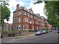
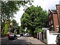
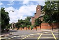
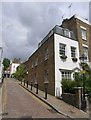
Photos of NW3 1HG


Area Information
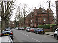
Living in NW3 1HG means residing within a specific postcode cluster that defines a distinct residential patch in England. This small community encompasses an area size of 188 m² for its defined cluster, creating a tightly knit environment rather than a sprawling suburb. The population stands at 1,552 people, which establishes a close-knit neighbourhood dynamic where residents frequently know one another. Daily life here revolves around immediate accessibility to major transport hubs and local retail, stripping away the need for long commutes to the rest of London. You will find yourself in a setting where the convenience of Hampstead and Finchley Road stations creates a practical rhythm for your week. The area operates as a focused residential pocket, avoiding the noise and chaos of larger urban districts while maintaining strong links to them. Residents benefit from a location that prioritises function over grandeur, focusing entirely on the efficient delivery of housing and transport connections. This makes NW3 1HG a pragmatic choice for those who value a clear, straightforward living arrangement without unnecessary complexity. The sheer density allows for quick access to services, meaning your morning coffee or evening grocery run remains a short journey.
- Area Type
- Postcode
- Area Size
- 188 m²
- Population
- 1552
- Population Density
- 15821 people/km²
The property market in NW3 1HG is heavily skewed towards rental living rather than ownership. With home ownership at just 33%, the vast majority of residents rent their homes. This market dynamic suggests that flats are the predominant accommodation type, a fact confirmed by the specific listing of flats as the main residential style. For buyers looking at homes in NW3 1HG, this data indicates a strong market for leasehold apartments rather than freehold houses. The high proportion of renters often correlates with areas where commuting costs are lower due to proximity to transport links, allowing individuals to rent rather than buy. The small area size of 188 m² for this cluster further supports the prevalence of flats over larger detached properties. If you are considering purchasing, you must frame your search around flats specifically, as this is the shell of the local housing stock. Conversely, if you are a tenant, the 33% ownership rate means you share the estate with other long-term renters and potential first-time buyers entering the market. The market operates on a model of density and proximity, where value is derived from location efficiency rather than land volume.
House Prices in NW3 1HG
Showing 6 properties
| Address | Type | Beds | Baths | Last Sale Price | Last Sale Date | |
|---|---|---|---|---|---|---|
| Flat 4, Albany House, 50 Flask Walk, London, NW3 1HG | Flat | 2 | 2 | - | - | |
| Flat 1, Albany House, 50 Flask Walk, London, NW3 1HG | Flat | - | - | - | - | |
| Flat 3, Albany House, 50 Flask Walk, London, NW3 1HG | Flat | - | - | - | - | |
| Flat 5, Albany House, 50 Flask Walk, London, NW3 1HG | Flat | - | - | - | - | |
| Flat 2, Albany House, 50 Flask Walk, London, NW3 1HG | Flat | - | - | - | - | |
| Flat 6-7, Albany House, 50 Flask Walk, London, NW3 1HG | Flat | - | - | - | - |
Energy Efficiency in NW3 1HG
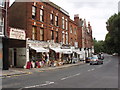
The lifestyle in NW3 1HG is defined by immediate access to a diverse mix of retail, transport, and leisure options. Retail consumers can walk to Sainsburys Hampstead, Tesco Heath, or Planet Organic Hampstead, all of which are noted as being within practical reach of the postcode. These three grocery stores alone offer something for everyone, from standard weekly shopping to organic specialist produce. Transport links are extensive, with five metro stations and five rail stations within easy distance. Notable hubs include Hampstead Station, Belsize Park Station, Finchley Road Station, Hampstead Heath Station, and Finchley Road and Frognal Station. You can also explore the area via waterbus routes at London Zoo Waterbus Stop, Camden Lock Waterbus, and Little Venice Waterbus Stop. The lifestyle here is fast-paced and efficient, with no need to travel far for daily necessities. The presence of multiple coach stations, including London Victoria Coach Station Arrivals and the Green Line Coach Station, expands your travel horizons beyond the tube network. This density of amenities ensures that your leisure time is spent in your local neighbourhood rather than commuting to find distractions.
Amenities
Schools
Families considering living in NW3 1HG have access to at least one primary school with a verified rating. New End Primary School is the listed educational facility serving this area. The school holds an Ofsted rating of good, which places it above the baseline requirement for educational quality. This single entry point for primary education suggests that further or secondary schools are likely located just beyond the immediate boundaries of the 188 m² cluster. The presence of a rated good school provides a solid foundation for families with younger children, ensuring a recognised standard of instruction. You can rely on the Ofsted classification as a metric of performance without needing to guess at quality. The proximity of this school to the residential cluster makes it a practical choice for parents navigating the daily routine of education. While there are no secondary schools listed in the immediate vicinity data, the backing of a good-rated primary institution is a concrete asset for the community.
| Rank | School | Type | Entry gender | Ages |
|---|
Explore more schools in this area
Go to Schools tabDemographics
The community in NW3 1HG reflects a mature demographic profile with a median age of 47 years. The most common age range consists of adults between 30 and 64 years, indicating a population established in their careers and families. This age distribution suggests a neighbourhood where long-term residents dominate, rather than transient populations seeking temporary accommodation. Home ownership sits at a level of 33%, meaning two out of every three households are likely renting. This high rental proportion defines the social fabric of the area, offering flexibility for tenants while limiting equity growth for new buyers. The predominant ethnic group is White, which forms the cultural background of the majority of the resident population. Accommodation throughout this section is primarily flats, aligning with the density of the postcode cluster and the age profile of its inhabitants. There are no designated deprived areas or specific inequality metrics listed for this postcode, so the standard of living relies on the intrinsic quality of the flats and their proximity to amenities. You are entering an area where stability meets flexibility, characterised by a steady flow of adult professionals paying rent for high-quality urban living.
Household Size
Accommodation Type
Tenure
Ethnic Group
Religion
Household Composition
Age
Household Deprivation
NS-SEC
Explore more demographic insights in this area
Go to Demographics tabPlanning
Planning Constraints
- Flood RiskPremium
- Ramsar Wetland SitesPremium
- Area of Outstanding Natural BeautyPremium
- Protected Nature ReservePremium
- Protected WoodlandPremium