Area Overview for NW26 9HG
Photos of NW26 9HG


Area Information
Living in NW26 9HG offers a specific residential experience defined by its density and location. This postcode spans a small residential cluster with a total population of 1,851 people. The area functions as a tight-knit neighbourhood rather than a sprawling district, meaning local news and community events spread quickly. Residents benefit from immediate proximity to major London transport hubs without the sprawl of outer boroughs. Daily life revolves around access to Harlesden, Willesden, and Acton, which are just moments away by public transport. You will find the environment is quiet by comparison to central London, yet connected to the wider city network. The character here is shaped by plasterboardited streets and close-quarter living typical of this postcode sector. Whether you seek a quiet morning commute or rapid access to city amenities, the location serves both purposes. The compact size of the cluster ensures services are within short walking or cycling distance. This neighbourhood suits those who prioritise efficiency and established local links over open green space. You gain immediate access to a functioning urban ecosystem while maintaining a sense of local intimacy. The area represents a practical choice for commuters needing reliable transit without the high cost of central London addresses. Your dailyRoutine starts with reliable digital connections and ends with convenient retail access. The simplicity of the layout makes navigating the area straightforward for new residents.
- Area Type
- Postcode
- Area Size
- Not available
- Population
- 1851
- Population Density
- 11858 people/km²
Homes in NW26 9HG are characterised by a specific mix of tenure and building style. Flats dominate the accommodation type, which defines the architectural footprint of the area. You will encounter multi-unit buildings rather than detached houses or bungalows. Only 21 per cent of residents own their homes, meaning the majority of the market consists of rental properties. This dynamic suggests a robust letting sector rather than a traditional owner-occupied street of brick terraced houses. Prospective buyers looking at this small area should expect high density and lack of private gardens. The low ownership percentage indicates strong demand from renters across different income levels. You might find it easier to rent a flat here than to purchase freehold property. The local stock suits professionals and shared housing arrangements who prioritise location over square footage. Landlords benefit from the university corridor and commuting belt that feeds into this postcode. Tenants enjoy the convenience of being flat-based while working in London city or the M4 corridor. The property market reflects the practical needs of commuters and young professionals. Investing in rentals here offers steady occupancy prospects. Purchasing a property in this cluster requires careful budgeting due to limited space. The distinction between owner and renter is sharply defined by the 79 per cent non-ownership figure.
House Prices in NW26 9HG
No properties found in this postcode.
Energy Efficiency in NW26 9HG
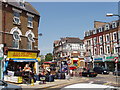
Daily life in NW26 9HG benefits from immediate access to major retail and transport hubs. You can shop at Iceland Harlesden, Tesco Harlesden, or the Co-op in Kensal, all within practical reach. These retailers provide essentials and groceries without the need for online ordering. Public transport options include five rail stations such as Willesden Junction Station and Willesden Junction Low Level Railway Station. Metro lines connect through North Acton, East Acton, and Dollis Hill Station, offering seamless tube access. Five bus routes link to Victoria Coach Station and Green Line Coach Station for intercity travel. Water transport services operate from Little Venice, Kew Pier, and London Zoo Waterbus Stop for leisure journeys. This variety means you can choose trains, tubes, coaches, or boats for your daily commute. Shopping provisions are plentiful with five notable retail locations nearby. Dining options often cluster around these major supermarket locations and station forecourts. The transport network allows you to live on the edge while working in the financial district. You reach the city centre within minutes rather than hours. The proximity to Harlesden High Street means local culture and independent traders are close by. Residents enjoy the convenience of multiple transport modes without needing a private vehicle. Your weekend trips to Richmond or Hyde Park start from a station or waterbus stop minutes away.
Amenities
Schools
Education options near NW26 9HG cater to specific local needs and private preferences. Harlesden Primary School stands as a state primary option with a Good Ofsted rating. This school serves the core community requirement for state education in the younger age brackets. For families seeking independent education, Scott House School offers an alternative pathway as an independent institution. Special needs families have access to TCS Primary (Special Needs) School nearby, ensuring inclusive educational provision within the local network. The absence of secondary school names in the immediate vicinity suggests these families often transition to larger catchment areas or larger secondary institutions further away. You must plan carefully regarding secondary school placements as local data only covers primary and special needs provision. The coexistence of state, independent, and special needs schools gives the area flexible options for different child requirements. Parents choosing Harlesden Primary School gain the reassurance of a government-verified standard. Families considering Scott House School access a private curriculum model just outside the immediate postcode boundary. The mix indicates a community divided between state-sponsored education and private choices. When selecting a school, verify transport links to these specific locations as they lie just beyond the immediate residential cluster.
| Rank | School | Type | Entry gender | Ages |
|---|---|---|---|---|
| 1 | Harlesden Primary School | primary | N/A | N/A |
| 2 | Scott House School | independent | N/A | N/A |
| 3 | TCS Primary (Special Needs) School | special | N/A | N/A |
Explore more schools in this area
Go to Schools tabDemographics
The community within NW26 9HG is dominated by adults aged between 30 and 64 years. This age group forms the most common demographic, indicating a neighbourhood settled by established households rather than young families or retirees. The median age is 47, which reinforces the presence of long-term residents managing mortgages or pursuing later-life careers. Home ownership stands at 21 per cent of the population, suggesting a significant proportion of residents rent their accommodation. This statistic highlights that many households here lease properties rather than own them outright. Most accommodation types consist of flats, shaping the physical layout of streets with upper and lower floors. The predominant ethnic group is White, reflecting the traditional demographics of the broader London counties where this postcode sits. These figures describe a mature population living in high-density housing. The low ownership rate combined with a flat-heavy stock creates a market where tenants outnumber owners. You will encounter neighbours who appreciate stability and quiet, given the age profile. The community focus often centres on practical concerns such as transport links and access to amenities rather than playground culture. Living here means sharing space with people in similar life stages who value convenience and connectivity.
Household Size
Accommodation Type
Tenure
Ethnic Group
Religion
Household Composition
Age
Household Deprivation
NS-SEC
Explore more demographic insights in this area
Go to Demographics tabPlanning
Planning Constraints
- Flood RiskPremium
- Ramsar Wetland SitesPremium
- Area of Outstanding Natural BeautyPremium
- Protected Nature ReservePremium
- Protected WoodlandPremium
- Crime RiskPremium