Area Overview for NW2 4ND
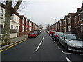
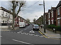
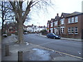
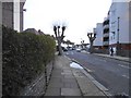
Photos of NW2 4ND


Area Information
NW2 4ND represents a specific residential cluster within the London postal district, defined by a tightly knit community of 1,677 residents. This postcode area functions as a contained neighbourhood where daily life revolves around established local routines and proximity to wider transport links. The population suggests a mature settlement rather than a rapidly expanding development zone, offering stability for those seeking to settle in a defined part of North West London. Living in NW2 4ND means residing in an environment that prioritises privacy and established housing structures over high-density living. The area functions as a quiet residential pocket, separate from the immediate bustle of larger towns while maintaining access to essential services. Residents benefit from a location that is easily accessible to major transport hubs without being situated in their immediate footprint. This balance provides a practical setting for commuters who require a short journey into central London but value the separation of their home life from office pressures. The character of this postcode is shaped by its limited population, which fosters a sense of familiarity among neighbours. There are no sprawling shopping districts or towering skyscrapers within the small boundary of 4ND itself. Instead, the local identity is built around the homes that line the streets and the services reachable within a short walk or bus ride. For homebuyers, this translates to a specific slice of London life that combines residential comfort with functional connectivity to the rest of the metropolitan area. It is a straightforward choice for individuals who prefer a clear, manageable environment over the complexity of larger, less defined districts.
- Area Type
- Postcode
- Area Size
- Not available
- Population
- 1677
- Population Density
- 10716 people/km²
The property market in NW2 4ND is characterised by a housing stock predominantly made up of houses, according to the accommodation type data. This distinction sets the area apart from denser parts of London where apartments and blocks of flats are more common. With 43 per cent of homes owned outright by residents, the market leans heavily towards owner-occupation, signaling that many buyers have entrusted their savings to properties within this specific postcode. This high rate of home ownership implies that the area offers strong stability and likely consistent property values. Properties here are not merely transient rentals but long-term assets, often reflecting the needs of families or couples who require the space provided by a house. For prospective buyers looking at homes in NW2 4ND, this suggests a buying environment where the seller may have been living there for years, often leading to realistic pricing and a clear understanding of the home's history. The nature of the housing stock means that individuals seeking a house with a garden, separate rooms, or a more standalone footprint will find their requirements met in this cluster. While flats may be present, the data confirms that the architecture of NW2 4ND is oriented towards detached or semi-detached structures. This orientation influences the local lifestyle, providing more external space for residents compared to flat living. Investors or buyers interested in this specific segment of the London market should note that the supply of properties is defined by this house-heavy profile, which commands a different set of considerations than the rental-heavy flats found in other areas.
House Prices in NW2 4ND
No properties found in this postcode.
Energy Efficiency in NW2 4ND
Daily life for residents of NW2 4ND is supported by a diverse range of amenities located within practical reach of their homes. Shopping conveniences are readily available, with five notable retail points including Sainsburys Brent Willesden, Co-op Willesden, and Sainsburys Willesden. These supermarkets provide essential groceries and household goods, meaning residents do not need to travel far for fresh food or basic necessities. The presence of a Co-op alongside major supermarket chains ensures variety in price points and shopping preferences. Transport links enhance the lifestyle by allowing easy access to wider opportunities. Five metro options are within reach, featuring Dollis Hill Station, Neasden Station, and Kilburn Station as key hubs. For those who prefer rail travel, five additional stations serve the area, including Cricklewood, Brent Cross West Station, and Brondesbury Park Station. This density of transport choices means that commuters can select the route that best suits their schedule without relying on a single transport node. Leisure and travel capacity are further expanded by the presence of five ferry stops, such as Little Venice Waterbus Stop, London Zoo Waterbus Stop, and Camden Lock Waterbus. This unique feature offers residents scenic and direct water-borne access to central London attractions. Additionally, three major bus stops serve the neighbourhood, including London Victoria Coach Station Arrivals and London Victoria Coach Station. The combination of these five metro lines, five rail stations, three bus hubs, and five ferry stops creates a transport-rich environment that prioritises choice and convenience for the local population.
Amenities
Schools
Education is a central consideration for families moving into the neighbourhood, and NW2 4ND benefits from several schools listed as being in close proximity. Gladstone Park Primary School operates in the area and holds a 'good' Ofsted rating, providing a solid academic foundation for young children starting their schooling. This designation confirms that the institution meets high standards of educational provision and care. The immediate area also includes Gladstone Park Junior School and Gladstone Park Infant School, both identified as primary institutions serving different age groups within the same educational complex. This setup allows for a continuous educational journey for children without the need for them to leave the local vicinity of NW2 4ND. The presence of multiple stages of primary education – infant and junior – alongside a separate primary school rating indicates a robust infrastructure for early and middle childhood learning. For parents selecting schools near NW2 4ND, the concentration of these institutions offers practical convenience. The 'good' rating of Gladstone Park Primary School specifically assures buyers that their children will receive education that meets the government's expectations. The data does not list secondary schools, meaning families with older children may need to look beyond this immediate postcode, but the local primary options are clearly defined and accessible. The consistency in naming between the Infant, Junior, and Primary schools suggests an integrated approach to education that supports the community's long-term settlement patterns.
| Rank | School | Type | Entry gender | Ages |
|---|
Explore more schools in this area
Go to Schools tabDemographics
The community living in NW2 4ND is defined by a mature demographic profile, reflecting its status as an established residential zone. The median age of 47 years places the area well past the prime housing-hunting years of younger generations, indicating a neighbourhood comprised largely of families and older adults who have chosen this location for its stability and convenience. The most common age range consists of adults between 30 and 64 years, confirming that the area attracts residents who are firmly rooted in their long-term plans. Home ownership stands at 43 per cent, a significant figure that suggests nearly half of the households in this postcode area have substantial investment in their local homes. This level of ownership creates a neighbourhood where many residents have deep ties to the streets, likely resulting in a watchful and supportive community environment. The remaining households, which include the other 57 per cent, likely consist of renters or those in temporary accommodation, adding a layer of diversity to the social fabric. Accommodation type data indicates that houses dominate the housing stock, offering a distinct alternative to the prevalence of flats found in other London districts. This preference for houses aligns with the older age profile, as single-family dwellings provide the space and privacy that many adults over 30 and over 60 require. White residents form the predominant ethnic group, maintaining the traditional character often associated with older suburbs in North West London. Combined, these facts paint a picture of a stable, family-oriented community where property values remain a key consideration for both owners and the small percentage of renters who live nearby.
Household Size
Accommodation Type
Tenure
Ethnic Group
Religion
Household Composition
Age
Household Deprivation
NS-SEC
Explore more demographic insights in this area
Go to Demographics tabPlanning
Planning Constraints
- Flood RiskPremium
- Ramsar Wetland SitesPremium
- Area of Outstanding Natural BeautyPremium
- Protected Nature ReservePremium
- Protected WoodlandPremium