Area Overview for NW10 0BE
Photos of NW10 0BE
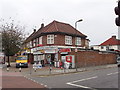
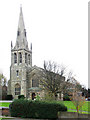
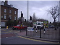
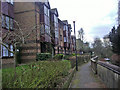
100 photos from this area
Area Information
Key information about the NW10 0BE including its size, population, and administrative classification.
- Area Type
- Postcode
- Area Size
- 8811 m²
- Population
- 1547
- Population Density
- 7459 people/km²
House Prices in NW10 0BE
47
Properties
£305,167
Average Sold Price
£130,000
Lowest Price
£485,000
Highest Price
Showing 47 properties
| Address | Type | Beds | Baths | Last Sale Price | Last Sale Date | |
|---|---|---|---|---|---|---|
| 16 Quainton Street, London, NW10 0BE | Terraced | 3 | 1 | £485,000 | Oct 2022 | |
| 10 Quainton Street, London, NW10 0BE | Terraced | 3 | - | £400,000 | Jun 2022 | |
| 8 Quainton Street, London, NW10 0BE | house | - | - | £443,000 | Dec 2021 | |
| 32 Quainton Street, London, NW10 0BE | Cottage | 3 | 1 | £410,000 | Dec 2020 | |
| 58 Quainton Street, London, NW10 0BE | Terraced | 3 | - | £430,000 | Jan 2019 | |
| 56 Quainton Street, London, NW10 0BE | Terraced | 3 | 1 | £375,000 | May 2018 | |
| 40 Quainton Street, London, NW10 0BE | Flat | - | - | £350,000 | Jan 2018 | |
| 38 Quainton Street, London, NW10 0BE | Flat | - | - | £350,000 | Jan 2018 | |
| 44 Quainton Street, London, NW10 0BE | Flat | 1 | 1 | £250,000 | Aug 2016 | |
| 48 Quainton Street, London, NW10 0BE | Terraced | 3 | 1 | £372,000 | Apr 2016 |
Page 1 of 5
Energy Efficiency in NW10 0BE
Amenities
Schools
| Rank | School | Type | Entry gender | Ages |
|---|
Explore more schools in this area
Go to Schools tabDemographics
Household Size
Family (3-5 people)
most common
Accommodation Type
Flats
most common
Tenure
25
majority
Ethnic Group
White
most common
Religion
N/A
most common
Household Composition
N/A
most common
Age
47
median
Adults (30-64 years)
most common
Household Deprivation
N/A
with no deprivation
NS-SEC
20
in Lower managerial occupations
Explore more demographic insights in this area
Go to Demographics tabPlanning
Planning Constraints
- Flood RiskPremium
- Ramsar Wetland SitesPremium
- Area of Outstanding Natural BeautyPremium
- Protected Nature ReservePremium
- Protected WoodlandPremium