Area Overview for NW1 6XR
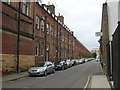
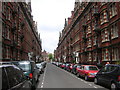
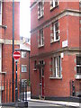
Photos of NW1 6XR

Area Information
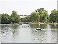
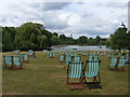
Living in NW1 6XR places you within a small residential cluster covering 2,386 square metres in north-west Inner London. The postcode serves a population of 1,431 people, creating a close-knight environment distinct from the wider city centre. This area sits adjacent to Regent's Park, a 410-acre Royal Park with a history dating back to King Henry VIII. The land was originally Marylebone Park, a hunting ground before Prince Regent commissioned John Nash to redesign it in the 1810s. Today, the park features Grade I listed gardens, Queen Mary's Gardens, and the London Zoo. Regent's University London occupies the site of the former South Villa within the park grounds. You will find yourself living in an area where daily life is shaped by proximity to major historical landmarks and modern education facilities. The specific coordinates locate this cluster near Baker Street and the Edgware Road. While the area is compact, its connection to the Royal Park defines the local character. Residents enjoy access to the Broad Walk and Avenue Gardens without needing to travel far. The presence of Francis Holland School nearby adds to the established feel of the neighbourhood. This is a settled environment where the history of the Regent's Park Ward influences current living arrangements for hundreds of households in a very defined geographical space.
- Area Type
- Postcode
- Area Size
- 2386 m²
- Population
- 1431
- Population Density
- 21013 people/km²
The property market in NW1 6XR is heavily influenced by the fact that flats are the primary accommodation type. You are looking at a housing stock designed for vertical living rather than traditional terrace or detached homes. Because 48% of residents own their homes, nearly half the market involves private buyers managing assets or moving into established properties. The remaining half operates within the rental sector or shared ownership schemes. This split suggests a dynamic market where investment buyers coexist with residents seeking permanent homes. Buying a home in this small cluster means you are purchasing a unit within a larger structure, which often comes with service charges and leasehold terms. The area is too small to support a traditional street of varied house types, so your options will centre on apartments or converted flats. If you are considering homes in NW1 6XR, you must account for the density and the specific laws governing flats. The predominance of this housing type makes the area attractive to professionals who work nearby in Marylebone or Holborn. Given the high density of the London market, properties in this postcode generally hold steady value due to the scarcity of such small, well-located residential zones. It is a market driven by location rather than plot size.
House Prices in NW1 6XR
No properties found in this postcode.
Energy Efficiency in NW1 6XR
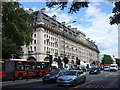
Living in NW1 6XR offers immediate access to a variety of amenities within practical reach. Retail options include Co-op Park, Tesco Marylebone, and Co-op London, which provide daily grocery and shopping needs. Public transport is highly developed, with Baker Street, Edgware Road, and Regent's Park Stations allowing quick access to the city centre. The River Fleet and canal network feature waterbus stops at London Zoo Waterbus, Little Venice Waterbus, and Camden Lock Waterbar. You will find the area is surrounded by significant transport interchanges, including London Victoria Coach Station, Green Line Coach Station, and Victoria Coach Station for long-distance travel. Bond Street, Paddington, and London Euston Railway Station stations allow you to access London's major terminals. The lifestyle here is characterised by convenience and variety. You can walk to the London Zoo, established between 1826 and 1828, or visit Queen Mary's Gardens in the Inner Circle. The Avenue Gardens and Broad Walk provide green spaces for relaxation. This mix of retail, transport, and parkland ensures your daily life in NW1 6XR is rich with opportunity without requiring significant travel distances.
Amenities
Schools
Families in NW1 6XR have access to Francis Holland School, a nearby independent institution. As the only school listed in the immediate vicinity, this private option serves children within the area. Independent schools often offer smaller class sizes and specific curricular focuses compared to state-maintained alternatives. By choosing an independent school, parents in NW1 6XR bypass the state admissions lottery and secure a place based on fees and application criteria. The presence of this single independent school suggests that residents may have already selected an education path before moving to the area or opt to live within walking or short bus distance of this specific campus. You do not have data on other school types in this immediate small cluster, meaning Francis Holland School is the primary educational reference point. For families with children, the distance to Francis Holland School becomes a key factor in your decision to live in NW1 6XR. The school's independent status adds a layer of exclusivity and choice to the local offering. Residents rely on this specific facility for their children's education needs within the safe and known environment of the Regent's Park vicinity.
| Rank | School | Type | Entry gender | Ages |
|---|
Explore more schools in this area
Go to Schools tabDemographics
The community in NW1 6XR is defined by a median age of 47, with adults between 30 and 64 years old forming the most common age range. This demographic profile indicates a mature neighbourhood where residents often live with established ties to the local area. Ownership is split fairly evenly, with 48% of homes occupied by owners. The remaining 52% of the housing stock consists of rentals or shared ownership properties, reflecting a balanced mix of investment and living arrangements. You will find that flats are the predominant accommodation type in this postcode. This layout suits single professions and small families who prefer ground-level access or shared building amenities. The resident population is predominantly White, which shapes the cultural dynamics of the local group. With a population density suggesting a concentrated community, neighbours likely interact frequently within the narrow bounds of the 2,386 square metre area. The age skew towards middle age may influence local shops, with a demand for services catering to adults rather than young children or teenagers. This demographic reality means the area feels stable, with fewer fluctuations in household composition compared to areas with younger populations. Knowing exactly who lives here helps you understand the pace and rhythm of daily life in NW1 6XR.
Household Size
Accommodation Type
Tenure
Ethnic Group
Religion
Household Composition
Age
Household Deprivation
NS-SEC
Explore more demographic insights in this area
Go to Demographics tabPlanning
Planning Constraints
- Flood RiskPremium
- Ramsar Wetland SitesPremium
- Area of Outstanding Natural BeautyPremium
- Protected Nature ReservePremium
- Protected WoodlandPremium