Area Overview for NW1 6XE
Photos of NW1 6XE
Area Information
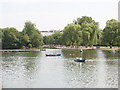
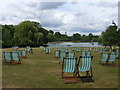
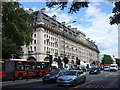
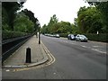
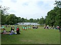
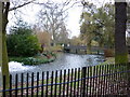
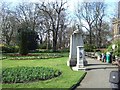
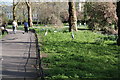
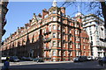
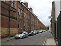
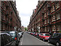
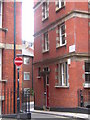
Living in NW1 6XE means residing within Regent's Park Ward, a compact residential cluster situated in north-west Inner London. This specific postcode covers just under half a hectare, providing a dense environment for its estimated 1,431 residents. The location places you immediately adjacent to one of London's most significant Green Spaces, a 410-acre Royal Park with Grade I listed historic garden resources. The land historically served as Marylebone Park, a hunting ground appropriated by King Henry VIII before the Prince Regent commissioned John Nash to redesign the site in the 1810s as a pleasure garden featuring villa residences. Today, this history underpins a neighbourhood defined by proximity to major landmarks such as the London Zoo, Queen Mary's Gardens, and Regent's University London. While the area lacks a defined character description in available records, its physical positioning within the vicinity of postcode NW1 5HP confirms its integration into a prestigious royal setting. You benefit from direct access to the park's Broad Walk and Avenue Gardens without needing to travel far. The immediate surroundings include the station at Baker Street, connecting you to the heart of the capital. This small cluster offers a specific slice of life where historic architecture meets modern connectivity, appealing to those who value immediate access to world-class amenities and greenery within a highly urbanised context.
- Area Type
- Postcode
- Area Size
- 4681 m²
- Population
- 1431
- Population Density
- 21013 people/km²
The property market in NW1 6XE is defined by a distinct lack of large terraced or semi-detached houses due to high density constraints. Flats constitute the main accommodation type found within this specific postcode area. This structural reality shapes the buying landscape significantly, as buyers are entering a market focused on vertical living solutions rather than standalone properties. With 48% of homes owner-occupied, the area presents a viable route for long-term investment or primary residence purchase, yet nearly half of the residents remain on the rental ladder. Given the extremely high population density of 305,716 people per square kilometre, finding space is challenging. The smallest area size recorded for this postcode is 4681 square metres, confirming that freehold detached homes are unlikely to exist here. Instead, the market caters to those seeking efficient, urban living close to Regent's Park. Prospective buyers should expect competition for well-maintained flats in buildings that historic records show were part of the original villa residences commissioned by the Prince Regent. The proximity to major stations like Baker Street commands a premium in the market. While infinite variety is not a feature of this small cluster, the flats offered provide direct access to the amenities of Regent's Park Ward, making them attractive to professionals working in central London who prioritise location over traditional garden space.
House Prices in NW1 6XE
Showing 98 properties
| Address | Type | Beds | Baths | Last Sale Price | Last Sale Date | |
|---|---|---|---|---|---|---|
| Flat 1 First Floor, 241-243 Baker Street, London, NW1 6XE | Flat | - | - | - | - | |
| Flat 1, 235 Gloucester Place, London, NW1 6XE | Flat | - | - | - | - | |
| Flat 3, 235 Baker Street, London, NW1 6XE | Flat | 2 | 1 | - | - | |
| Bsement Flat, 241-243 Baker Street, London, NW1 6XE | Flat | 2 | 1 | - | - | |
| Flat 2, 235 Gloucester Place, London, NW1 6XE | Flat | - | - | - | - | |
| Ground Floor Gym, 219 Baker Street, London, NW1 6XE | Leisure | - | - | - | - | |
| Flat 2 Second Floor, 241-243 Baker Street, London, NW1 6XE | Flat | 1 | - | - | - | |
| Flat 3 Third Floor, 241-243 Baker Street, London, NW1 6XE | Flat | - | - | - | - | |
| First Floor Flat, 231 Baker Street, London, NW1 6XE | Flat | 2 | 1 | - | - | |
| Flat 2, 245-247 Baker Street, London, NW1 6XE | Flat | - | - | - | - |
Energy Efficiency in NW1 6XE
Daily life in NW1 6XE is characterised by immediate access to extensive retail and leisure amenities without requiring a journey into the city centre. Five retail outlets, including Tesco Marylebone and Co-op London, are within practical reach, ensuring you can source groceries and essentials locally. Your cultural and leisure life is enriched by the proximity to five metro stations and five rail stops, granting entry to areas like Marylebone and Westminster. You can also utilise five ferry services, including the Little Venice Waterbus Stop and Camden Lock Waterbus, for scenic travel. The area sits adjacent to Regent's Park, which houses the London Zoo, Queen Mary's Gardens, and the Avenue Gardens, providing free outdoor space for recreation. Historical features like the Broad Walk add to the aesthetic quality of your daily walk. Restaurants and dining options are plentiful along the Edgware Road and Baker Street corridors. The presence of Regent's University London also contributes to the intellectual atmosphere of the neighbourhood. Living here offers a convenient blend of urban services and royal parkland. You can commute to places like Bond Street or Paddington in minutes while maintaining a lifestyle centred on local shops and a historic park. This balance of accessibility and green space defines the resident experience in this postcode.
Amenities
Schools
Families considering NW1 6XE have one specific independent school listed in the immediate vicinity, Francis Holland School. This institution offers a non-state education path, providing an alternative to the local state sectors. The data does not specify an Ofsted rating for this venue, so parents must seek current grading directly from the school or the Department for Education website. The limited number of listed options suggests that families rely on this single named independent provider or must look further afield for secondary education choices. With the median age of residents at 47 years, many children in the demographic of school age likely reside in neighbouring postcodes rather than strictly within these 4681 square metres. The presence of Regent's University London nearby also indicates higher education infrastructure within easy reach of the postcode. While the data only confirms Francis Holland School, the location within Regent's Park Ward means access to top-tier private education is practically assured. Parents moving here should be prepared to look beyond the immediate postcode for comprehensive state school options, as the small size of the area restricts the number of local provisions. The independent sector presence aligns with the high-value nature of the surrounding royal parklands.
| Rank | School | Type | Entry gender | Ages |
|---|
Explore more schools in this area
Go to Schools tabDemographics
The community within NW1 6XE reflects an older, established demographic profile. The median age stands at 47 years, with adults aged between 30 and 64 forming the most common age range. This concentration suggests a neighbourhood occupied by families and professionals who have long-term ties to the area. Regarding housing tenure, 48% of households own their homes, indicating a mixed market but with a significant portion of owner-occupiers. The remaining residents likely include renters or buyers within the conventional shared ownership sector. Flats represent the predominant accommodation type, which aligns with the area's high urban density and proximity to major transport hubs. The population density is extremely high, calculated at 305,716 people per square kilometre. This figure drives the area's character as a tightly packed urban environment where neighbours are potentially only yards away. Predominantly White residents make up the largest ethnic group in this cluster. The demographic data paints a picture of a mature residential zone where stability is common. The age structure implies that daily life is often centred around later adulthood or retirement planning, yet the high density ensures the area remains dynamic and close to central London resources.
Household Size
Accommodation Type
Tenure
Ethnic Group
Religion
Household Composition
Age
Household Deprivation
NS-SEC
Explore more demographic insights in this area
Go to Demographics tabPlanning
Planning Constraints
- Flood RiskPremium
- Ramsar Wetland SitesPremium
- Area of Outstanding Natural BeautyPremium
- Protected Nature ReservePremium
- Protected WoodlandPremium