Area Overview for NW1 6EN
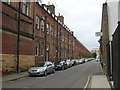
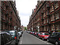
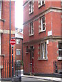
Photos of NW1 6EN

Area Information
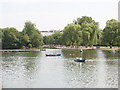
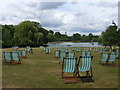
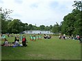
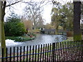
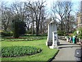
This specific postcode area, NW1 6EN, offers a compact living environment within a small residential cluster measuring just 3265 metres squared. You are situated in a setting where 1545 people call this small footprint home, resulting in a population density of 1366 people per square kilometre. The location is defined by its proximity to Regent's Park, a 410-acre Royal Park historically known as Marylebone Park and later redesigned by architect John Nash in the 1810s. This historic site features Grade I listed gardens and contains notable structures such as Queen Mary's Gardens, the Avenue Gardens, and the Broad Walk. Regent's University London occupies the site of the former South Villa within the park boundaries. Daily life here is characterised by close quarters and immediate access to major metropolitan features. The area sits near established transport hubs and commercial zones, placing residents steps away from the London Zoo and various university facilities. Living in NW1 6EN means prioritising location over expansive private grounds, as the total area size restricts the potential for extensive individual gardens. You are surrounded by a mix of protected heritage sites and educational institutions. The immediate vicinity includes coordinates near 51.523251 and -0.15207, which place the postcode directly within the influence of this historic royal park. This creates a unique residential cluster where the boundary between domestic life and public recreational space is exceptionally thin.
- Area Type
- Postcode
- Area Size
- 3265 m²
- Population
- 1545
- Population Density
- 1366 people/km²
The property market in NW1 6EN is defined by limited space and a specific housing stock type. Flats are the predominant accommodation type, making this a significant choice for those seeking property in this cluster. With a total area size of only 3265 metres squared, the scarcity of land prevents the development of large villas or sprawling estates. Instead, the built environment consists of small residential clusters designed to maximise density within the constraints of the London marketplace. The home ownership rate stands at 40%, meaning nearly half of the 1545 residents are landlords or tenants rather than owners. This dynamic suggests a competitive rental market alongside a smaller but established base of owner-occupiers. Buyers looking at homes in NW1 6EN should expect to encounter a mix of investment properties and family flats, rather than large family homes found in more suburban postcodes. The high population density of 1366 people per square kilometre further constrains the available housing options. You are looking at a micro-markets where every unit is relatively close to another. The presence of 40% owner-occupied homes indicates that the area has not been entirely converted into a landlord-only estate, though the flat-led construction dominates the skyline. For investors, the flat ratio offers potential for close management, but the floor plans are inherently limited by the small total area size.
House Prices in NW1 6EN
Showing 59 properties
Energy Efficiency in NW1 6EN
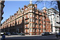
Life in NW1 6EN is enriched by immediate access to major retail, leisure, and cultural amenities. Within practical reach, you will find five key retail outlets, including the Co-op Park, M&S Marylebone Rail SF, and Tesco Lisson Grove Supermarket. Shopping needs are met within a short walk or tube ride. Cultural and leisure activities are supported by five commuter rail stations, five metro stations, and three notable bus routes. The London Zoo Waterbus Stop, Little Venice Waterbus Stop, and Camden Lock Waterbus offer scenic water transport options close to the area. Residents enjoy proximity to the Regent's Park Ward, which contains the 410-acre Royal Park land. Notable features within this green space include Queen Mary's Gardens, the Avenue Gardens, and the Broad Walk. Regent's University London occupies the historic South Villa site, adding an academic atmosphere to the park perimeter. Dining and shopping are accessible via nearby landmarks such as the London Business School and South Hampstead Station. The area benefits from a dense concentration of services, allowing you to meet essential needs quickly. Whether commuting, shopping, or relaxing in Queen Mary's Gardens, the infrastructure of NW1 6EN supports a varied lifestyle. The connectivity to Baker Street Station and Paddington Station means you are just a few stops from wider city entertainment. This blend of green space and urban convenience defines the daily rhythm for households in this postcode.
Amenities
Schools
Education options for families living in or near NW1 6EN are anchored by the London Business School, located in the immediate vicinity. This institution is categorised as an 'other' type facility within the local educational landscape. While specific Ofsted ratings and details on primary or secondary schools are not listed in the available information for this postcode, the presence of the London Business School provides a higher education option. For younger children, the nearest primary or secondary establishments fall outside the specific data scope for this area. The school mix implies that this postcode serves a mature demographic more connected to professional education than traditional schooling. The London Business School is a significant educational anchor nearby, influencing the character of the local community. If you are considering schools near NW1 6EN, you must look beyond the immediate postcode boundaries to find standard state or private primary and secondary providers. The current data highlights the London Business School as the only named educational institution. Families in NW1 6EN likely utilise transport links to reach schools further afield in the NW1 or W1 districts, given the concentration of the local population in flats and the mature age profile.
| Rank | School | Type | Entry gender | Ages |
|---|
Explore more schools in this area
Go to Schools tabDemographics
The community in NW1 6EN displays a mature demographic profile, with a median age of 47 years. Adults between the ages of 30 and 64 years represent the most common age range for residents in this cluster. This age distribution suggests a population consisting largely of those with established careers or approaching retirement, rather than young families or students. Housing tenure reflects this stability, with 40% of residents owning their homes outright or through a mortgage. The remaining 60% rent their properties, indicating a balanced market of both owner-occupiers and tenants. Accommodation types are dominated by flats, meaning you will see significantly fewer detached houses or semi-detached properties in this specific postcode. This is consistent with the small total area size of 3265 metres squared and the high population density of 1366 people per square kilometre. The ethnic makeup of the area is predominantly White, aligning with broader trends in north-west inner London. Living in NW1 6EN involves navigating a high-density urban environment typical of West London. The combination of a mature age group and a high proportion of flats creates a residential atmosphere focused on convenience and proximity to services rather than suburban spread or large garden spaces.
Household Size
Accommodation Type
Tenure
Ethnic Group
Religion
Household Composition
Age
Household Deprivation
NS-SEC
Explore more demographic insights in this area
Go to Demographics tabPlanning
Planning Constraints
- Flood RiskPremium
- Ramsar Wetland SitesPremium
- Area of Outstanding Natural BeautyPremium
- Protected Nature ReservePremium
- Protected WoodlandPremium