Area Overview for NW1 5DB
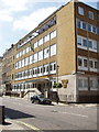
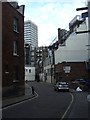
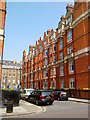
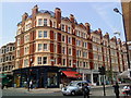
Photos of NW1 5DB


Area Information
Living in NW1 5DB offers a dwelling experience defined by extreme density within a compact urban footprint. This specific postcode covers only 3,228 square metres, yet it supports a population of 1,181 residents. The resulting population density reaches 365,839 people per square kilometre, placing this cluster firmly within the high-intensity residential fabric of London. You are stepping into a zone where space is at a premium and immediate proximity to city life is the defining feature. The area functions as a small, concentrated residential unit that benefits from being surrounded by major infrastructure. Daily life here is characterised by constant accessibility to transport hubs and commercial zones. While the location is central, the sheer volume of residents in such a small area creates a specific rhythm to living. You will find yourself amidst a community where every street intersects with significant activity. The environment is strictly urban with no surrounding open space within the boundary itself. Your routine will be dictated by the efficiency of public transport connections rather than local greenery or wide roads. Understanding this tight packing of homes is crucial when considering this location as your next residence.
- Area Type
- Postcode
- Area Size
- 3228 m²
- Population
- 1181
- Population Density
- 16380 people/km²
The property market in NW1 5DB is almost exclusively geared towards tenancy rather than ownership. Data confirms that only 7% of residents own their homes, meaning the area functions largely as a rental hub. Homes in NW1 5DB are predominantly flats, reflecting the high-density construction typical of this specific postcode. You will find very few detached or semi-detached houses in this immediate cluster due to the constrained 3,228 square metre area size. This market configuration means you are looking at a location where purchase is less common than investment or long-term renting. Buyers targeting this specific address should approach it with the expectation of purchasing a flat within a larger block of residential units. The low ownership rate also suggests that service charges and ground rents are likely significant factors in the cost of living. When evaluating homes in NW1 5DB, factoring in the overheads of communal maintenance is essential. The surrounding areas may offer more varied property types, but this specific postcode remains a flat-centric environment suited to those prioritising location over garden space or independent ownership. Your search should focus on leasehold properties if you intend to settle in this zone.
House Prices in NW1 5DB
Showing 15 properties
Energy Efficiency in NW1 5DB
Living in NW1 5DB places you at the epicentre of London's commercial and retail offerings. You have access to five notable metro stations, five retail outlets, five rail hubs, five ferry stops, and three major bus terminals within practical reach. Specific shopping destinations include M&S Edgware, Sainsburys Westminster, and Tesco Lisson for grocery and essential needs. Leisure and travel options are equally extensive, with Paddington Station and London Zoo Waterbus Stop nearby for weekend trips. Commuting is straightforward via Edgware Road Station, Baker Street Station, and New Covent Garden Market proximity is implied by the retail density. The area does not list specific parks or natural reserves within its immediate boundary, so leisure relies heavily on the surrounding city amenities. Dining options are vast given the proximity to multiple major stations and restaurants hidden in the vicinity of the listed retail parks. You have the convenience of three coach stations, including London Victoria Coach Station Arrivals, Green Line Coach Station, and Victoria Coach Station for national travel. This density of services means you rarely need to leave the borough for daily tasks involving food, travel, or shopping.
Amenities
Schools
Families considering homes in NW1 5DB have access to two named educational institutions in their vicinity. Supportabadby the North Westminster Community School operates as a primary school for young children. Similarly, the Ark King Solomon Academy serves as an academy with an Ofsted rating of outstanding. This rating indicates that the administrative and educational standards of this academy meet the highest regulatory benchmarks. The presence of these two specific schools provides a direct education route without needing to travel far to other zones. You will not find a third school listed in the immediate data for this postcode, so your choices are limited to these two options. The mix includes both a primary institution and a large academy, covering different stages of secondary education. While one school holds an outstanding rating, the other operates without a specified grade in the available information. This selection means you must weigh the proven track record of the Ark school against the local provision of the community school. For families relocating to this dense urban cluster, these facilities represent the core of the local education landscape. Proximity to these schools is a tangible benefit of living in NW1 5DB.
| Rank | School | Type | Entry gender | Ages |
|---|
Explore more schools in this area
Go to Schools tabDemographics
The community profile of NW1 5DB reflects an mature demographic with a median age of 47 years. Most residents fall within the 30-64 years age range, illustrating a population primarily composed of adults and established households. The area exhibits a high rate of renting rather than ownership, with only 7% of residents owning their homes. This statistic indicates that the vast majority of people living here are tenants rather than landlords or buyers. Consequently, the housing stock is dominated by flats, which aligns with the rental-heavy nature of the neighbourhood. The predominant ethnic group in this postcode is White, though the proximity to central London suggests cultural diversity extends beyond the immediate area. This demographic mix creates a static yet affluent feel typical of inner-city corridors. The low home ownership figure suggests that frequent turnover may occur as tenants move in and out. You should expect a community composed primarily of long-term renters and potentially uprooted workers requiring flexible housing. The age structure implies a lack of young children or very elderly residents within this specific cluster. Understanding these figures helps you gauge the transient nature of the community compared to suburban estates.
Household Size
Accommodation Type
Tenure
Ethnic Group
Religion
Household Composition
Age
Household Deprivation
NS-SEC
Explore more demographic insights in this area
Go to Demographics tabPlanning
Planning Constraints
- Flood RiskPremium
- Ramsar Wetland SitesPremium
- Area of Outstanding Natural BeautyPremium
- Protected Nature ReservePremium
- Protected WoodlandPremium