Area Overview for NW1 1BY
Photos of NW1 1BY


Area Information
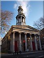
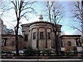
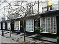
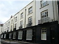
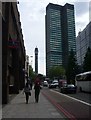
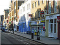
The postcode NW1 1BY identifies a small residential cluster in the London Borough of Camden, home to a population of 1348. This ward, which contains the St Pancras and Somers Town area, sits at the intersection of significant transport history and modern urban density. The location is bounded by Euston Road, Eversholt Street, Crowndale Road, Pancras Road, and railway approaches to St Pancras Station. You will be situated near Chalton Street, the historical heart of this developing district. Modern development here began in the 1790s when Earl Camden took fields north and west of St Pancras Old Church. Somers Town emerged as a residential district south and east of the Old Church, originally developing as a working-class community. In 1834, Lord Somers accepted the London and Birmingham Railway Company proposal to build Euston Station within this ward. The area sits amongst three major railway termini: Euston, Kings Cross, and St Pancras, which opened in 1868. Living in NW1 1BY means existing in an area shaped by heavy infrastructure and historical social housing projects. Father Basil Jellicoe established the St Pancras House Improvement Society in 1924, leading to the creation of the Sidney Street estate in 1938. This estate includes 250 flats in blocks named after saints, with St George's block being the first all-electric apartment block in the United Kingdom. You will find yourself in a neighbourhood where surviving Georgian houses are sought after, yet Council-owned blocks remain a defining feature of the landscape.
- Area Type
- Postcode
- Area Size
- Not available
- Population
- 1348
- Population Density
- 21080 people/km²
The property market in NW1 1BY is defined by a high proportion of rental properties due to a home ownership rate of only 5%. You will predominantly find flats rather than traditional family homes with gardens. This low ownership percentage indicates that most people living in this postcode rent their homes, suggesting a transient or student population alongside long-term tenants of the social housing estates. The housing stock includes living blocks named after saints, such as those found in the Sidney Street estate. St George's block holds historical significance as the first all-electric apartment block in the United Kingdom. Some of these blocks have generally prevented gentrification, keeping housing costs relatively accessible for those who can secure tenancy. However, surviving Georgian houses towards Bloomsbury and Holborn have become increasingly sought after in recent years, creating a contrast in property value within the wider ward. For buyers looking at this small area and its immediate surroundings, the market implies limited availability of owner-occupied stock. The presence of dense, Council-owned residential blocks means you should expect to deal primarily with the private rental sector if purchasing existing homes is not viable. The majority of homes in NW1 1BY are flats, which suits urban dwellers but may lack the space found in other London suburbs. Potential buyers must navigate a market where the 5% ownership figure reflects a strong landlord and tenant dynamic rather than a traditional owner-occupier society.
House Prices in NW1 1BY
Showing 11 properties
Energy Efficiency in NW1 1BY
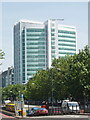
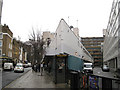
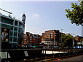
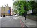
Living in NW1 1BY offers immediate access to major retail chains and hospitality venues due to the high density of major thoroughfares. Within practical reach, you will find M&S Euston Rail SF, Sainsburys London, and M&S St Pancras Main Rail SF. These retailers ensure essential shopping needs are met without requiring significant travel beyond the immediate postcode area. The transport hubs themselves function as lifestyle anchors. Five railway stations and five metro stations provide frequent service to London Euston Railway Station and London St Pancras International LL. This connectivity extends to water transport, with five ferry options available including the Camden Lock Waterbus, London Zoo Waterbus Stop, and Savoy Pier. The presence of Victoria Coach Station and the Green Line Coach Station further expands your mobility options for regional travel. You will find that dining, shopping, and leisure facilities are clustered around the railway approaches and Chalton Street. The area supports a bustling presence of residents linking to these amenities through short daily commutes. St Pancras and Somers Town ward character means you are surrounded by the busy infrastructure of London's main gates rather than quiet, isolated green spaces. This proximity to Euston Road and Pancras Road ensures you are at the centre of London's commercial and transport activity.
Amenities
Schools
There are three primary schools listed near NW1 1BY catering to young residents and local families. These options include St Aloysius Catholic Primary School, St Aloysius Roman Catholic Infant School, and Maria Fidelis Catholic School FCJ. All three are designated as primary institutions, meaning they serve children in the earlier stages of their education. Maria Fidelis Catholic School FCJ carries a Ofsted rating of good. This positive assessment provides a concrete benchmark for the academic standard offered within the immediate vicinity of the postcode. The presence of two other names starting with St Aloysius indicates a concentration of Catholic educational provision in this specific cluster. You will find that the area offers a selection of faith-based primary education rather than a mix of state and academy schools. For families considering NW1 1BY, this selection provides continuity if children attend these schools from infancy through to the end of compulsory education. St Aloysius Roman Catholic Infant School will typically take the younger children, allowing them to remain within the same school trust before transferring. St Aloysius Catholic Primary School likely takes the older primary children or operates as a through school alongside the infant unit. The data confirms no secondary schools are listed in the immediate proximity, meaning older students or teenagers would need to travel further for middle or high education.
| Rank | School | Type | Entry gender | Ages |
|---|
Explore more schools in this area
Go to Schools tabDemographics
The community in NW1 1BY has a distinct age profile concentrated among adults between 30 and 64 years old. The median age for residents is 47, indicating a population skewed towards middle age rather than families with young children or large groups of retirees. This demographic structure aligns with the character of an area containing dense, Council-owned residential blocks that have historically served less affluent residents, students, and refugees. Home ownership stands at a low 5% within this specific postcode area. Consequently, the vast majority of accommodation consists of flats. You are likely to encounter a landscape dominated by apartment blocks rather than detached houses or semi-detached property. This low rate of ownership suggests the area functions primarily as a rental market, fitting the description of a ward with a concentration of social housing. The predominant ethnic group is White, though the diverse history of the area includes French Revolution refugees and subsequent social housing tenants. The ward is among the 10% most deprived areas in the country, a fact reflected in the high density of housing and the prevalence of Council ownership. While suffering from this classification does not define quality of life, it shapes the neighbourhood's economic reality. The population saw recorded figures of 13,818 in the 2011 Census, though the current cluster for NW1 1BY is smaller at 1348. This mix creates a community defined by affordability and a housing stock designed for working occupants rather than owners.
Household Size
Accommodation Type
Tenure
Ethnic Group
Religion
Household Composition
Age
Household Deprivation
NS-SEC
Explore more demographic insights in this area
Go to Demographics tabPlanning
Planning Constraints
- Flood RiskPremium
- Ramsar Wetland SitesPremium
- Area of Outstanding Natural BeautyPremium
- Protected Nature ReservePremium
- Protected WoodlandPremium