Area Overview for NW1 0DF
Photos of NW1 0DF


Area Information
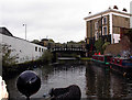
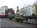
Living in NW1 0DF places you at the historic heart of St Pancras and Somers Town, a ward in the London Borough of Camden. This postcode covers a specific residential cluster bounded by Euston Road, Eversholt Street, Crowndale Road, and Pancras Road. The area is centred around Chalton Street and sits amongst three major railway termini. Euston opened in 1838, Kings Cross in 1852, and St Pancras Railway Station in 1868. These landmarks define the character of the neighbourhood and anchor daily life for residents. The Somerset family originally developed the land south and east of St Pancras Old Church, creating Somers Town as a distinct district. Today, the ward encompasses a mix of surviving Georgian houses and dense, Council-owned residential blocks. You are surrounded by the railway approaches to St Pancras Station, which remain a dominant feature of the local landscape. This unique history shapes your immediate environment and connects you to a rich past dating back to the 1790s. The area remains a significant residential district within north London, offering accessibility to major transport hubs while retaining its historic identity.
- Area Type
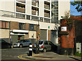
- Postcode
- Area Size
- Not available
- Population
- 1691
- Population Density
- 23101 people/km²
The property market in NW1 0DF is defined by a strong dominance of the rental sector, as only 14% of residents are homeowners. This low ownership rate signals that the area functions primarily as a location for tenants rather than buyers establishing themselves through purchase. The predominant accommodation type in this postcode is flats, which typicals the social housing landscape shaped by the Sidney Street estate completed in 1938. St George's block within that estate was the first all-electric apartment block in the United Kingdom, setting a precedent for the housing stock. Surviving Georgian houses, particularly those situated near Bloomsbury and Holborn, have seen increasing demand in recent years. However, the concentration of Council-owned residential blocks has largely prevented widespread gentrification across the whole ward. For buyers looking at this small area and its immediate surroundings, the market offers a mix of historic masonry housing and modernized social housing. The 1920s and 1930s social housing design remains a key feature, with 250 flats originally in the Sidney Street estate named after saints. Understanding this market structure is essential for anyone evaluating property opportunities here.
House Prices in NW1 0DF
No properties found in this postcode.
Energy Efficiency in NW1 0DF
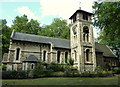
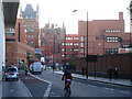
Your lifestyle in NW1 0DF benefits from immediate access to a wide variety of amenities within practical reach. Five retail locations serve your daily shopping needs, including Sainsburys Mornington, Co-op Camden, and Aldi Camden. These supermarkets and independent stores are conveniently located near Mornington Crescent. For those who prefer water travel, five ferry options are available, including the Camden Lock Waterbus, London Zoo Waterbus Stop, and Savoy Pier. This allows you to explore the city via the river without using buses or trains. Public transport infrastructure is extensive, with five metro and five rail stations close by, such as St Pancras International Station and Camden Road Station. You are also within reach of three bus routes that connect you to major hubs like London Victoria Coach Station Arrivals and the Green Line Coach Station. The nearby St Pancras Old Church stands on Pancras Road, offering historical interest and a local landmark. St Pancras Railway Station remains a dominant feature that shapes the rhythm of life in the area. The combination of retail, leisure, and transport facilities creates a convenient centre for your daily activities.
Amenities
Schools
| Rank | School | Type | Entry gender | Ages |
|---|
Explore more schools in this area
Go to Schools tabDemographics
The community in NW1 0DF has a median age of 47 years, with adults aged between 30 and 64 forming the most common age group. This indicates a predominantly mature population settling into long-term homes in this central London location. A significant portion of the ward has a diverse mix of residents, including students and refugees, reflecting the area's role as a housing stronghold for various income levels. The area ranks among the 10% most deprived in the country, a fact marked by the high concentration of Council-owned properties that have largely prevented rapid gentrification. Only 14% of households in this postcode own their homes, leaving the vast majority in the rental sector. The predominant accommodation type is flats, which align with the social housing provision in the locality. While the predominant ethnic group is White, the presence of refugees and the high student population contribute to a dynamic cultural environment. Residents live in close proximity to one another within a ward that had a total population of 13,818 at the 2011 Census. This demographic profile creates a tightly knit neighbourhood where residents rely heavily on each other and on the robust transport links surrounding the ward.
Household Size
Accommodation Type
Tenure
Ethnic Group
Religion
Household Composition
Age
Household Deprivation
NS-SEC
Explore more demographic insights in this area
Go to Demographics tabPlanning
Planning Constraints
- Flood RiskPremium
- Ramsar Wetland SitesPremium
- Area of Outstanding Natural BeautyPremium
- Protected Nature ReservePremium
- Protected WoodlandPremium