Area Overview for N9 0DX
Photos of N9 0DX
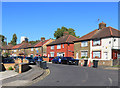
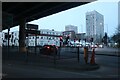
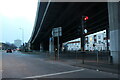
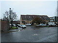
50 photos from this area
Area Information
Key information about the N9 0DX including its size, population, and administrative classification.
- Area Type
- Postcode
- Area Size
- 1.1 hectares
- Population
- 1822
- Population Density
- 5910 people/km²
House Prices in N9 0DX
61
Properties
£220,281
Average Sold Price
£50,000
Lowest Price
£445,000
Highest Price
Showing 61 properties
| Address | Type | Beds | Baths | Last Sale Price | Last Sale Date | |
|---|---|---|---|---|---|---|
| 101B Felixstowe Road, Edmonton, N9 0DX | Flat | - | - | £200,000 | Jun 2024 | |
| 97 Felixstowe Road, Edmonton, N9 0DX | Terraced | 4 | 1 | £445,000 | May 2024 | |
| 25 Felixstowe Road, Edmonton, N9 0DX | Terraced | 3 | 2 | £385,000 | Apr 2023 | |
| 65 Felixstowe Road, Edmonton, N9 0DX | Terraced | 3 | 1 | £372,500 | Jun 2022 | |
| 39 Felixstowe Road, Edmonton, N9 0DX | Terraced | 3 | 1 | £350,000 | Jun 2022 | |
| 37 Felixstowe Road, Edmonton, N9 0DX | Terraced | 3 | 1 | £352,000 | Nov 2021 | |
| 13 Felixstowe Road, Edmonton, N9 0DX | house | - | - | £360,000 | Feb 2021 | |
| 41 Felixstowe Road, Edmonton, N9 0DX | Terraced | 3 | 1 | £340,000 | Nov 2020 | |
| 101A Felixstowe Road, Edmonton, N9 0DX | Flat | 2 | 1 | £161,500 | Feb 2020 | |
| 89 Felixstowe Road, Edmonton, N9 0DX | Terraced | 3 | 1 | £380,000 | Sep 2019 |
Page 1 of 7
Energy Efficiency in N9 0DX
Amenities
Schools
| Rank | School | Type | Entry gender | Ages |
|---|
Explore more schools in this area
Go to Schools tabDemographics
Household Size
Family (3-5 people)
most common
Accommodation Type
Houses
most common
Tenure
38
majority
Ethnic Group
White
most common
Religion
N/A
most common
Household Composition
N/A
most common
Age
47
median
Adults (30-64 years)
most common
Household Deprivation
N/A
with no deprivation
NS-SEC
19
in Lower managerial occupations
Explore more demographic insights in this area
Go to Demographics tabPlanning
Planning Constraints
- Flood RiskPremium
- Ramsar Wetland SitesPremium
- Area of Outstanding Natural BeautyPremium
- Protected Nature ReservePremium
- Protected WoodlandPremium