Area Overview for N8 0RP
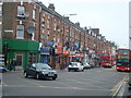
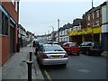
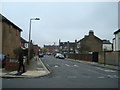
Photos of N8 0RP


Area Information
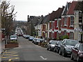
N8 0RP is a compact residential postcode area in north London, covering just 3,520 square metres and home to 2,436 residents. Its high population density of 692,015 people per square kilometre reflects a tightly packed cluster of properties, primarily flats. The area’s proximity to transport hubs and amenities makes it a practical choice for those prioritising connectivity. With a median age of 47 and a population skewed towards adults aged 30–64, it caters to a mature, established community. Daily life here is defined by convenience: major retail chains like Tesco and Sainsburys are within reach, and rail, metro, and bus services provide seamless access to central London. While the area’s small size limits expansion, its strategic location near Haringey and Barnet offers a blend of urban and suburban living. For buyers, N8 0RP’s appeal lies in its accessibility and the balance between residential comfort and proximity to London’s infrastructure. However, its density and flat-dominated housing stock mean it’s more suited to those seeking rental options or compact living rather than large family homes.
- Area Type
- Postcode
- Area Size
- 3520 m²
- Population
- 2436
- Population Density
- 16639 people/km²
N8 0RP’s property market is characterised by a high proportion of rental units, with only 37% of homes owned by residents. The accommodation type is overwhelmingly flats, which aligns with the area’s small size and high density. This suggests a market that prioritises short-term lettings and compact living over owner-occupied properties. For buyers, this means limited availability of flats for purchase, with most options likely to be in the rental sector. The small area size also means that the housing stock is concentrated, making competition for available properties intense. Those seeking larger homes or family-friendly spaces may need to look beyond N8 0RP’s immediate boundaries. The flat-dominated market also implies that property values are likely to be influenced by proximity to transport links and amenities, as these are key selling points in such densely populated areas.
House Prices in N8 0RP
Showing 47 properties
| Address | Type | Beds | Baths | Last Sale Price | Last Sale Date | |
|---|---|---|---|---|---|---|
| Flat 1, 586-588 Green Lanes, Hornsey, London, N8 0RP | Flat | - | 1 | - | - | |
| Flat A, 574 Green Lanes, Hornsey, London, N8 0RP | Flat | - | - | - | - | |
| Educators Forum, 584 Green Lanes, Hornsey, London, N8 0RP | office_workshop | - | - | - | - | |
| 582 Green Lanes, Hornsey, London, N8 0RP | Flat | 2 | 1 | - | - | |
| Rear Of, 580 Green Lanes, Hornsey, London, N8 0RP | Flat | - | - | - | - | |
| 570 GREEN LANES, Hornsey, London, N8 0RP | Terraced | - | - | - | - | |
| Flat B, 574 Green Lanes, Hornsey, London, N8 0RP | Flat | - | 1 | - | - | |
| Flat C, 578 Green Lanes, Hornsey, London, N8 0RP | Flat | - | - | - | - | |
| Ground Floor Flat, 576 Green Lanes, Hornsey, London, N8 0RP | Flat | - | - | - | - | |
| First Floor Flat, 576 Green Lanes, Hornsey, London, N8 0RP | Flat | - | - | - | - |
Energy Efficiency in N8 0RP
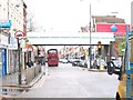
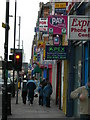
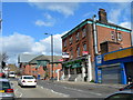
Residents of N8 0RP enjoy a range of amenities within walking or short transit distance. Retail options include major supermarkets like Tesco Harringay, Iceland Haringey, and Sainsburys Haringey West, ensuring daily shopping needs are met. Transport links are extensive, with rail, metro, and bus services connecting to key destinations such as Hornsey, Wood Green, and Manor House. For leisure, the area’s proximity to ferry stops like Camden Lock Waterbus and London Zoo Waterbus Stop offers alternative travel routes and scenic options. While the data does not specify parks or recreational spaces, the presence of multiple transport hubs and retail centres suggests a lifestyle focused on convenience and accessibility. The compact nature of the area means amenities are tightly clustered, reducing the need for long commutes. However, the lack of detailed information on green spaces or cultural venues means further local research may be necessary for a full picture of the area’s character.
Amenities
Schools
Residents of N8 0RP have access to two primary schools within practical reach: South Harringay Junior School and South Harringay Infant School. Both are rated highly by Ofsted, with the junior school receiving an outstanding rating and the infant school marked as good. This combination of school types provides a seamless transition for children from early years through to primary education. However, the absence of secondary school data means families may need to consider nearby areas for secondary schooling. The presence of two primary schools with strong ratings is a significant advantage for families prioritising education, though the lack of diversity in school options beyond primary level could be a limitation. For those seeking a school-focused community, N8 0RP offers a solid foundation, but further research into secondary education is advisable.
| Rank | School | Type | Entry gender | Ages |
|---|
Explore more schools in this area
Go to Schools tabDemographics
The population of N8 0RP is predominantly adults aged 30–64, with a median age of 47. This suggests a community of settled professionals and families, though the 37% home ownership rate indicates that a significant proportion of residents rent. The accommodation type is almost entirely flats, reflecting the area’s compact footprint and likely historical development as a high-density residential zone. The predominant ethnic group is White, though no specific data on diversity or deprivation is provided. The high population density, combined with the age profile, implies a stable, middle-aged demographic with established routines. For buyers, this means a market skewed towards rental properties and smaller units, with limited scope for large family homes. The lack of specific data on household composition or income levels means assumptions about deprivation or affluence cannot be made, but the area’s proximity to amenities suggests a reasonable quality of life for its residents.
Household Size
Accommodation Type
Tenure
Ethnic Group
Religion
Household Composition
Age
Household Deprivation
NS-SEC
Explore more demographic insights in this area
Go to Demographics tabPlanning
Planning Constraints
- Flood RiskPremium
- Ramsar Wetland SitesPremium
- Area of Outstanding Natural BeautyPremium
- Protected Nature ReservePremium
- Protected WoodlandPremium