Area Overview for N6 4RE
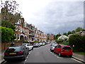
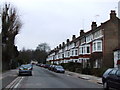
Photos of N6 4RE


Area Information
N6 4RE is a small residential postcode in north London, home to 1,597 people. It sits in a tightly knit cluster of properties, offering a quiet alternative to the city’s busier districts. The area is served by multiple transport hubs, including Highgate, East Finchley, and Tufnell Park metro stations, ensuring easy access to central London and beyond. Daily life here is shaped by proximity to schools, retail, and green spaces. The community is predominantly middle-aged, with a strong presence of families and professionals. While the area is compact, its connectivity to nearby amenities—such as Sainsburys Highgate, Tesco Highgate, and Co-op Food—makes it convenient for everyday needs. The low crime risk and absence of environmental constraints like protected woodlands or wetlands add to its appeal. For those seeking a balance between urban accessibility and suburban tranquility, N6 4RE offers a distinctive blend of practicality and livability.
- Area Type
- Postcode
- Area Size
- Not available
- Population
- 1597
- Population Density
- 2672 people/km²
The property market in N6 4RE is characterised by a 49% home ownership rate, with houses forming the predominant accommodation type. This suggests a mix of owner-occupied and rental properties, though the exact proportion of rentals is not specified. The presence of houses rather than flats or apartments indicates a more traditional housing stock, which may appeal to buyers seeking family-friendly layouts or larger living spaces. Given the area’s small size, the housing supply is likely limited, meaning buyers may need to consider nearby postcode areas for more options. The owner-occupation rate implies a degree of stability in the market, with fewer short-term rentals or speculative investment properties. For those prioritising property value retention, the absence of planning constraints such as protected woodlands or Areas of Outstanding Natural Beauty may reduce regulatory hurdles for development or renovation.
House Prices in N6 4RE
No properties found in this postcode.
Energy Efficiency in N6 4RE
Life in N6 4RE is enriched by its proximity to a range of amenities. Residents can access major retailers such as Sainsburys Highgate, Tesco Highgate, and Co-op Food, ensuring convenience for grocery shopping. The area’s transport links extend beyond metro and rail, with ferry services like Camden Lock Waterbus and Little Venice Waterbus Stop offering scenic routes along the Thames. Parks and open spaces are not explicitly mentioned in the data, but the absence of protected natural areas suggests potential for local green spaces. The presence of multiple bus routes, including Victoria Coach Station, enhances accessibility to events, workplaces, and leisure activities. The combination of retail, transport, and connectivity options creates a lifestyle that balances urban vibrancy with practicality, making daily life in N6 4RE both efficient and varied.
Amenities
Schools
Residents of N6 4RE have access to two primary schools within practical reach: Highgate Primary School, which holds an Ofsted rating of outstanding, and Highgate Infant School. Both institutions serve the local community, offering education for younger children. The presence of two primary schools in close proximity is a significant advantage for families, reducing the need for long commutes to education. Highgate Primary’s outstanding rating suggests high-quality teaching and facilities, which could be a key factor for parents prioritising academic standards. However, the data does not include secondary schools or further education providers, so families may need to look beyond the immediate area for secondary schooling. The availability of two primary schools reinforces the area’s suitability for households with young children, though the absence of detailed information on school capacity or catchment areas remains a consideration.
| Rank | School | Type | Entry gender | Ages |
|---|
Explore more schools in this area
Go to Schools tabDemographics
The population of N6 4RE is 1,597, with a median age of 47. The majority of residents fall within the 30-64 age range, reflecting a mature, stable community. Home ownership rates stand at 49%, suggesting a mix of owner-occupied and rental properties. The area is primarily composed of houses, which is uncommon in many parts of London. The predominant ethnic group is White, though specific data on diversity or deprivation is not provided. The age profile indicates a population likely focused on long-term residency, with fewer young families or students compared to other areas. This demographic structure may influence local services and amenities, with a focus on adult-oriented needs rather than childcare or educational infrastructure beyond primary schools. The absence of detailed diversity statistics means the community’s cultural composition remains less defined in the data.
Household Size
Accommodation Type
Tenure
Ethnic Group
Religion
Household Composition
Age
Household Deprivation
NS-SEC
Explore more demographic insights in this area
Go to Demographics tabPlanning
Planning Constraints
- Flood RiskPremium
- Ramsar Wetland SitesPremium
- Area of Outstanding Natural BeautyPremium
- Protected Nature ReservePremium
- Protected WoodlandPremium