Area Overview for N3 2AU
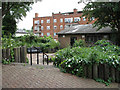
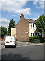
Photos of N3 2AU


Area Information
N3 2AU is a compact residential postcode in England, covering just 6,099 square metres and home to 2,287 residents. Its high population density of 374,959 people per square kilometre reflects a tightly knit community. The area is characterised by its focus on flats, which dominate the housing stock, catering to a population skewed towards adults aged 30–64. Daily life here is shaped by proximity to transport hubs and retail amenities, with residents within easy reach of multiple metro, rail, and ferry services. The postcode’s small size means it is a microcosm of urban living, where convenience of access to shops, schools, and transport is balanced against the challenges of limited space. Despite its density, the area benefits from a mix of retail options, including major chains like M&S and Waitrose, and is served by key stations such as West Finchley and Finchley Central. This makes N3 2AU a practical choice for those prioritising connectivity over expansive living space.
- Area Type
- Postcode
- Area Size
- 6099 m²
- Population
- 2287
- Population Density
- 5628 people/km²
The property market in N3 2AU is defined by its high density and reliance on flats. With 44% of residents owning their homes, the area is not primarily owner-occupied, suggesting a rental market that may cater to professionals and families seeking manageable living spaces. The prevalence of flats indicates limited scope for larger homes or detached properties, which could be a consideration for buyers seeking more space. The small area size means the housing stock is constrained, and those seeking properties may need to look beyond the immediate postcode. The compact nature of N3 2AU also means that proximity to transport and amenities is a key selling point, though this comes at the cost of limited private outdoor space. For buyers, this area is best suited to those prioritising location and convenience over expansive living quarters.
House Prices in N3 2AU
No properties found in this postcode.
Energy Efficiency in N3 2AU
Life in N3 2AU is shaped by its proximity to a range of amenities. Retail options include major chains such as M&S Byron Finchley BP, Waitrose Finchley, and Tesco East, offering everyday shopping needs. The area’s transport links extend beyond commuting, with ferry services providing access to water-based leisure activities near London Zoo and Little Venice. Residents also benefit from multiple metro and rail stations, ensuring seamless travel to cultural, commercial, and recreational hubs. While the data does not specify parks or leisure facilities within the postcode, the presence of ferry stops and nearby stations suggests opportunities for outdoor activities and social engagement. The compact nature of N3 2AU means that daily life is centred around convenience, with amenities within practical reach.
Amenities
Schools
The nearest school to N3 2AU is Our Lady of Lourdes RC School, a primary school with an Ofsted rating of ‘good’. This provides a reliable option for families with young children, though the absence of secondary schools in the data means parents may need to consider nearby areas for older children. The presence of a well-rated primary school is a positive for families prioritising education, but the lack of information on secondary options or other educational facilities means further research would be necessary for comprehensive planning. The school’s rating suggests a focus on quality teaching and student outcomes, which could be a deciding factor for homebuyers.
| Rank | School | Type | Entry gender | Ages |
|---|
Explore more schools in this area
Go to Schools tabDemographics
The population of N3 2AU is predominantly adults aged 30–64, with a median age of 47. This suggests a community with a strong presence of working-age individuals and families, though younger and older demographics are less represented. Home ownership is relatively low at 44%, indicating that a significant portion of residents are renters. The accommodation type is almost entirely flats, which aligns with the area’s high density and compact footprint. The predominant ethnic group is White, though the data does not provide further breakdowns. The age profile and home ownership rate imply a stable, mature community with limited turnover. However, the lack of specific data on deprivation or income levels means the quality of life for residents cannot be fully contextualised beyond the available statistics.
Household Size
Accommodation Type
Tenure
Ethnic Group
Religion
Household Composition
Age
Household Deprivation
NS-SEC
Explore more demographic insights in this area
Go to Demographics tabPlanning
Planning Constraints
- Flood RiskPremium
- Ramsar Wetland SitesPremium
- Area of Outstanding Natural BeautyPremium
- Protected Nature ReservePremium
- Protected WoodlandPremium