Area Overview for N22 6AH
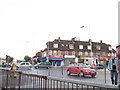
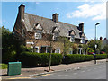
Photos of N22 6AH


Area Information
Living in N22 6AH means being part of a tightly packed residential cluster in England, where 1,393 people reside across just 2,426 square metres. This high population density creates a compact, community-focused environment, ideal for those seeking proximity to amenities and transport. The area’s character is shaped by its mix of housing stock and strong local infrastructure. With excellent broadband connectivity (a perfect score of 100) and reliable mobile coverage (85/100), residents enjoy seamless digital access, supporting both work and leisure. Nearby schools, such as Belmont Infant and Junior Schools, cater to families, while transport links like Turnpike Lane and Wood Green stations provide easy access to London’s transport network. The area’s low flood risk and absence of protected natural sites make it practical for long-term living, with a safety score of 76/100 indicating a below-average crime rate. N22 6AH is a microcosm of urban convenience, blending residential comfort with connectivity.
- Area Type
- Postcode
- Area Size
- 2426 m²
- Population
- 1393
- Population Density
- 9051 people/km²
N22 6AH is primarily an owner-occupied area, with 56% of homes owned by residents. The accommodation type is predominantly houses, suggesting a focus on family-friendly, semi-detached or terraced properties. Given the area’s small size and high density, the housing stock is likely limited, making it a niche market for buyers seeking proximity to transport and schools. The emphasis on owner-occupation indicates a stable, long-term resident base, which can contribute to a sense of continuity in the neighbourhood. However, the compact nature of the area means that property availability may be constrained, and buyers should consider the immediate surroundings for more options. The mix of housing types and ownership levels suggests a balance between private residency and potential rental properties, though the exact proportion of rentals is not specified.
House Prices in N22 6AH
No properties found in this postcode.
Energy Efficiency in N22 6AH
The lifestyle in N22 6AH is defined by its proximity to a range of amenities, from retail to transport. Nearby shops include Sainsburys Tottenham and Tesco Tottenham W, providing essential grocery and household supplies. The area’s transport hubs—such as Turnpike Lane Station and Whipps Cross Bus Interchange—offer direct links to London’s metro, rail, and bus networks, while ferry services like Camden Lock Waterbus add a unique dimension to travel. Though the data does not specify parks or leisure facilities, the presence of multiple transport and retail options suggests a convenient, active lifestyle. Residents can access urban amenities without long commutes, making daily life efficient. The compact nature of the area means that most needs are within walking or short transit distance, fostering a practical, community-oriented way of living.
Amenities
Schools
Residents of N22 6AH have access to two primary schools: Belmont Infant School and Belmont Junior School, both rated ‘good’ by Ofsted. These institutions provide a consistent educational foundation for young children, with the infant school catering to younger primary years and the junior school covering the upper primary phase. The presence of two schools in close proximity ensures that families have options for their children’s early education. The ‘good’ Ofsted ratings suggest reliable teaching standards and adequate resources, though no secondary schools are listed in the data. For families prioritising primary education, the availability of two rated schools is a significant advantage, reducing the need for long commutes to alternative institutions.
| Rank | School | Type | Entry gender | Ages |
|---|
Explore more schools in this area
Go to Schools tabDemographics
N22 6AH’s population of 1,393 is predominantly adults aged 30–64, with a median age of 47. This suggests a stable, established community, likely centred around family life. Home ownership stands at 56%, with houses being the primary accommodation type, reflecting a preference for private, long-term residency. The predominant ethnic group is White, though no specific diversity metrics are provided. The area’s high population density—574,251 people per square kilometre—implies a tightly knit neighbourhood, which can foster strong local ties but may also create challenges in terms of space and resource allocation. For buyers, this density underscores the need to prioritise proximity to amenities, as the area’s small size means limited expansion potential. The demographic profile indicates a mature, settled population, which could influence local services and community dynamics.
Household Size
Accommodation Type
Tenure
Ethnic Group
Religion
Household Composition
Age
Household Deprivation
NS-SEC
Explore more demographic insights in this area
Go to Demographics tabPlanning
Planning Constraints
- Flood RiskPremium
- Ramsar Wetland SitesPremium
- Area of Outstanding Natural BeautyPremium
- Protected Nature ReservePremium
- Protected WoodlandPremium