Area Overview for N19 4DS
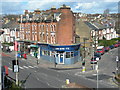
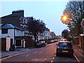
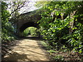
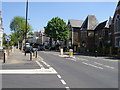
Photos of N19 4DS


Area Information
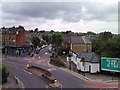
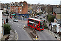
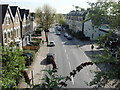
Living in N19 4DS offers a compact, residential experience shaped by its small cluster of homes and proximity to key transport hubs. With a population of 1,736, this area is characterised by a mature demographic, where the median age of 47 reflects a community of established adults, many in the 30–64 age range. The housing stock is predominantly flats, reflecting a rental-oriented market, with only 28% of residents owning their homes. Despite its modest size, N19 4DS is well-connected, with multiple rail, metro, and bus stops within reach. Broadband and mobile connectivity scores of 81 and 85 respectively ensure reliable digital access, supporting remote work and daily internet use. The area’s appeal lies in its balance of practicality and accessibility, with nearby amenities such as Tesco Hornsey and Upper Holloway Station offering convenience. For those seeking a quiet, low-flood-risk environment with average crime levels, N19 4DS provides a straightforward, no-frills living option in a well-served part of north London.
- Area Type
- Postcode
- Area Size
- Not available
- Population
- 1736
- Population Density
- 19140 people/km²
The property market in N19 4DS is defined by its high proportion of rental flats and low home ownership rate of 28%. This suggests that the area is primarily a rental market, with limited opportunities for owner-occupation. The dominance of flats indicates a housing stock suited to smaller households or individuals, rather than larger family homes. Given the area’s small size, the immediate surroundings likely offer similar housing types, reinforcing the notion that N19 4DS is part of a broader residential network with consistent property characteristics. For buyers, this means competition for flats may be high, and the market is unlikely to cater to those seeking detached homes or larger properties. The low home ownership rate also implies that property values may be more stable, with fewer fluctuations driven by owner investment.
House Prices in N19 4DS
No properties found in this postcode.
Energy Efficiency in N19 4DS
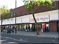
Residents of N19 4DS benefit from a range of nearby amenities that support daily life. Retail options include Tesco Hornsey, Co-op Holloway, and Sainsburys Archway, providing essential shopping within walking distance. Transport links are extensive, with five rail stations, five metro stops, and ferry services like the Camden Lock Waterbus offering diverse travel options. The area’s proximity to Upper Holloway Station and Green Line Coach Station ensures easy access to London’s broader transport network. While the data does not specify parks or leisure facilities, the presence of multiple transport hubs and retail outlets suggests a practical, urban lifestyle. The combination of retail, transport, and digital connectivity creates a functional environment, ideal for those prioritising accessibility over expansive green spaces.
Amenities
Schools
| Rank | School | Type | Entry gender | Ages |
|---|
Explore more schools in this area
Go to Schools tabDemographics
The community in N19 4DS is predominantly composed of adults aged 30–64, with a median age of 47. This suggests a stable, middle-aged population, likely with established careers and families. Home ownership is low, at just 28%, indicating that most residents are renters, which may reflect the area’s focus on rental flats. The accommodation type is almost exclusively flats, which aligns with the small, residential cluster description of the area. The predominant ethnic group is White, though no further breakdown of diversity is provided. The population size of 1,736 means the area is small enough to foster a close-knit community but not so large as to feel anonymous. The age profile and housing data suggest a practical, functional living environment, with limited scope for large families or multi-generational households.
Household Size
Accommodation Type
Tenure
Ethnic Group
Religion
Household Composition
Age
Household Deprivation
NS-SEC
Explore more demographic insights in this area
Go to Demographics tabPlanning
Planning Constraints
- Flood RiskPremium
- Ramsar Wetland SitesPremium
- Area of Outstanding Natural BeautyPremium
- Protected Nature ReservePremium
- Protected WoodlandPremium
- Crime RiskPremium