Area Overview for N18 1TG
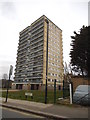
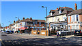
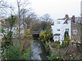
Photos of N18 1TG


Area Information
Living in N18 1TG means being part of a small, tightly knit residential cluster in north London. With a population of 2072, this area is characterised by its modest scale and proximity to key transport links. The community here skews towards adults aged 30–64, reflecting a mature demographic that likely values stability and convenience. Daily life is shaped by the area’s accessibility to rail and metro stations, which connect residents to wider London. While the housing stock is predominantly made up of houses, the relatively low home ownership rate of 46% suggests a mix of owner-occupied and rental properties. This balance may appeal to those seeking flexibility in housing. The area’s compact size means amenities are within practical reach, though its identity is defined more by its connectivity than by any singular landmark. For buyers, N18 1TG offers a quiet, functional base with straightforward access to urban opportunities, though its small footprint means the immediate surroundings are key to assessing long-term suitability.
- Area Type
- Postcode
- Area Size
- Not available
- Population
- 2072
- Population Density
- 5685 people/km²
The property market in N18 1TG is defined by its low home ownership rate of 46%, indicating that nearly half of residents rent their homes. This suggests a rental market that may cater to commuters or those seeking temporary housing. The accommodation type is predominantly houses, which is unusual for a small postcode area and may reflect a mix of semi-detached or terraced properties. Given the area’s size, the housing stock is likely limited, meaning buyers should consider the immediate surroundings for additional options. The prevalence of houses could imply larger properties, which may appeal to families or those prioritising space. However, the lower home ownership rate also suggests competition for available properties, particularly for those seeking to buy. Buyers should assess whether the area’s modest scale aligns with their long-term needs, as expansion options may be constrained.
House Prices in N18 1TG
No properties found in this postcode.
Energy Efficiency in N18 1TG
The lifestyle in N18 1TG is shaped by its proximity to a range of retail, transport, and leisure amenities. Within walking distance are shops such as M&S North Middlesex University Hospital, Spar, and Tesco Edmonton, providing everyday essentials. The area’s transport links are its strongest asset, with rail stations like Silver Street and White Hart Lane, as well as metro stops at Wood Green and Turnpike Lane, offering direct access to London’s transport network. The Whipps Cross Bus Interchange serves as a hub for regional routes, while the Camden Lock Waterbus connects to the Thames. Though the area lacks large parks or cultural landmarks, its practical connectivity means residents can access broader opportunities in nearby towns and the capital. The presence of multiple transport options and retail outlets ensures daily life is efficient, though the small scale of N18 1TG means community character is defined by its immediate surroundings rather than grand urban features.
Amenities
Schools
| Rank | School | Type | Entry gender | Ages |
|---|
Explore more schools in this area
Go to Schools tabDemographics
The population of N18 1TG is predominantly adults aged 30–64, with a median age of 47. This suggests a community of established professionals and families, likely drawn by the area’s transport links and housing options. Home ownership here is relatively low at 46%, indicating a significant proportion of residents rent their homes. The accommodation type is primarily houses, which may reflect a preference for more spacious living compared to flats. The predominant ethnic group is White, though the data does not specify further diversity metrics. The absence of detailed deprivation data means quality of life considerations such as income levels or access to services are not quantified here. However, the age profile and home ownership figures suggest a population that may prioritise stability over novelty, with a focus on practical living over high-end amenities.
Household Size
Accommodation Type
Tenure
Ethnic Group
Religion
Household Composition
Age
Household Deprivation
NS-SEC
Explore more demographic insights in this area
Go to Demographics tabPlanning
Planning Constraints
- Flood RiskPremium
- Ramsar Wetland SitesPremium
- Area of Outstanding Natural BeautyPremium
- Protected Nature ReservePremium
- Protected WoodlandPremium