Area Overview for N16 9LZ
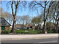
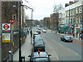
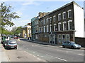
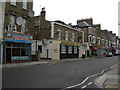
Photos of N16 9LZ


Area Information
Living in N16 9LZ means being part of a compact residential cluster in north London, where the population of 1977 residents creates a tightly knit community. The area is defined by its proximity to transport hubs and retail centres, making daily life convenient for commuters and shoppers alike. With a median age of 47, the neighbourhood is predominantly populated by adults in their 30s to 60s, reflecting a mature, stable demographic. Flats dominate the housing stock, suggesting a mix of owner-occupied and rental properties. While the area lacks major natural features or planning constraints, its strategic location near Stoke Newington and Canonbury stations ensures easy access to central London. Broadband quality is excellent, scoring 100, though mobile coverage is slightly lower at 85. For buyers, N16 9LZ offers a blend of practicality and accessibility, with schools, shops, and transport options within reach. However, a medium crime risk score of 54 means residents should remain vigilant, particularly in shared spaces. This postcode is ideal for those seeking a balance between urban convenience and a quieter residential environment.
- Area Type
- Postcode
- Area Size
- Not available
- Population
- 1977
- Population Density
- 16165 people/km²
The property market in N16 9LZ is characterised by a high concentration of flats, with 48% of homes owner-occupied and the rest likely rented. This suggests a housing stock that caters to smaller households or couples, rather than larger families. The predominance of flats may indicate limited scope for property expansion or redevelopment, which could affect long-term value appreciation. Given the small population of 1977, the area is unlikely to have a large inventory of homes, meaning competition for properties could be fierce. Buyers should consider that the market is not dominated by detached homes or larger plots, which may appeal to those seeking more space. The 48% home ownership rate also implies that a significant portion of the housing stock is available for rental, potentially offering opportunities for investors. However, the compact size of the area means that property choices are limited to a specific cluster, requiring buyers to prioritise proximity to amenities over a wide range of options.
House Prices in N16 9LZ
No properties found in this postcode.
Energy Efficiency in N16 9LZ
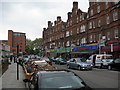
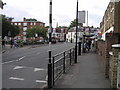
Life in N16 9LZ is shaped by its proximity to retail, transport, and leisure facilities. The area is within walking distance of five retail outlets, including Tesco Stoke Newington and Tesco Matthias, ensuring everyday shopping needs are met. Transport hubs like Rectory Road Station and Stoke Newington Station provide direct links to the city, while nearby ferry piers offer alternative routes along the Thames. The presence of Arsenal and Holloway Road metro stations adds to the area’s connectivity. For leisure, the mix of bus routes and coach stations opens access to broader destinations. While the data does not specify parks or recreational spaces, the abundance of transport and retail suggests a focus on convenience over green spaces. This lifestyle suits those prioritising accessibility and urban amenities, though those seeking extensive outdoor areas may need to look further afield. The compact nature of the area means that amenities are tightly clustered, reducing travel time but limiting diversity in options.
Amenities
Schools
The nearest school to N16 9LZ is Grasmere Primary School, a primary institution with a good Ofsted rating. This provides families with a reliable option for early education, though the absence of secondary schools in the immediate area may require students to travel to nearby districts. The presence of a single primary school suggests that the local education infrastructure is focused on younger children, with no data on secondary or specialist provision. For parents, this means planning for secondary schooling in adjacent areas, which could impact decisions about where to live. The good rating at Grasmere Primary indicates a standard of teaching and facilities that meet expectations, but the lack of diversity in school types—no grammar schools, academies, or specialist colleges—may limit choices for families with specific educational preferences.
| Rank | School | Type | Entry gender | Ages |
|---|
Explore more schools in this area
Go to Schools tabDemographics
The community in N16 9LZ is predominantly composed of adults aged 30 to 64, with a median age of 47. This suggests a population largely in their prime working years, potentially contributing to a stable local economy. Home ownership rates stand at 48%, indicating that nearly half of residents own their properties, while the remaining 52% are likely renters. The accommodation type is almost entirely flats, reflecting a housing stock suited to smaller households or couples. The predominant ethnic group is White, though no further breakdown of diversity is provided. With no data on deprivation levels, it is unclear how this affects access to services or quality of life. The age profile implies a community with established careers and families, though the absence of younger residents may influence local amenities and school demographics. This demographic structure shapes a neighbourhood that is neither overly youthful nor elderly, creating a balanced but potentially less dynamic social environment.
Household Size
Accommodation Type
Tenure
Ethnic Group
Religion
Household Composition
Age
Household Deprivation
NS-SEC
Explore more demographic insights in this area
Go to Demographics tabPlanning
Planning Constraints
- Flood RiskPremium
- Ramsar Wetland SitesPremium
- Area of Outstanding Natural BeautyPremium
- Protected Nature ReservePremium
- Protected WoodlandPremium