Area Overview for N16 5BL
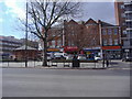
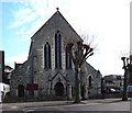
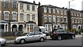
Photos of N16 5BL


Area Information
Living in N16 5BL means inhabiting a densely populated, compact postcode area of 5,144 square metres, home to 1,377 residents. This small cluster of homes is defined by its high population density — 267,694 people per square kilometre — which suggests a tightly knit, urban environment. The area’s character is shaped by its mix of residential flats and proximity to transport hubs. With a median age of 47 and a majority of residents aged 30–64, the community leans towards middle-aged adults, many of whom may be professionals or families seeking convenience. Daily life here is centred around nearby amenities, from retail outlets to rail stations, offering a blend of practicality and connectivity. The area’s compact size means residents are likely within walking distance of essential services, though the high density could imply limited green space. For those prioritising accessibility over spacious living, N16 5BL offers a compact, efficient urban footprint.
- Area Type
- Postcode
- Area Size
- 5144 m²
- Population
- 1377
- Population Density
- 13139 people/km²
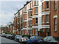
The property market in N16 5BL is characterised by a low home ownership rate of 28%, suggesting that the area is more rental-oriented than owner-occupied. The predominant accommodation type is flats, which aligns with the high population density and compact nature of the postcode. This indicates a housing stock tailored to urban living, with limited scope for larger homes or detached properties. For buyers, the small area size and high density may mean a constrained selection of properties, particularly if demand outstrips supply. The focus on flats could appeal to those prioritising convenience and proximity to transport, but it may also limit options for those seeking more space or private gardens. The market is likely competitive, with properties in this area serving a niche of renters or those seeking short-term urban housing.
House Prices in N16 5BL
Showing 54 properties
Energy Efficiency in N16 5BL
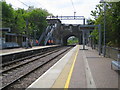
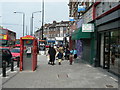
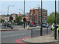
The lifestyle in N16 5BL is shaped by its proximity to a variety of retail, transport, and leisure amenities. Nearby shops include Morrisons Stoke, Iceland Stoke, and Whole Foods Market, offering a range of grocery and specialty shopping options. For transport, residents have access to five rail stations, such as Stamford Hill and Holloway Road, plus metro stops like Arsenal and Manor House, ensuring easy access to central London. Ferry services at Blackfriars Pier and Bankside Pier provide alternative travel routes, while bus networks connect to major hubs like London Victoria Coach Station. This density of amenities fosters convenience, allowing residents to meet daily needs without long commutes. The area’s compactness and accessibility make it ideal for those prioritising efficiency over expansive living spaces.
Amenities
Schools
The nearest school to N16 5BL is T T T Y Y School, an independent institution with an Ofsted rating of inadequate. This suggests that families relying on this school may face challenges in terms of educational quality or resources. The absence of other schools in the data highlights a limited choice for parents, particularly those seeking state-funded options. Independent schools often cater to specific needs, such as specialist curricula or smaller class sizes, but the inadequate rating raises concerns about performance or compliance with standards. For families prioritising school quality, this could be a critical consideration, potentially influencing decisions about relocation or additional educational investments. The single school in the area may also indicate a lack of competition or diversity in educational provision.
| Rank | School | Type | Entry gender | Ages |
|---|
Explore more schools in this area
Go to Schools tabDemographics
The community in N16 5BL is predominantly composed of adults aged 30–64, with a median age of 47. This suggests a population skewed towards middle-aged individuals, potentially including professionals, families, or retirees. Home ownership here is relatively low at 28%, indicating that a majority of residents are likely renters, which could reflect the area’s role as a secondary housing market. The accommodation type is primarily flats, aligning with the high population density. The predominant ethnic group is White, though no specific data on diversity or deprivation is provided. The age profile and housing stock suggest a stable, mature demographic, possibly with established careers and long-term residential patterns. The high density may also imply shared living arrangements or multi-generational households.
Household Size
Accommodation Type
Tenure
Ethnic Group
Religion
Household Composition
Age
Household Deprivation
NS-SEC
Explore more demographic insights in this area
Go to Demographics tabPlanning
Planning Constraints
- Flood RiskPremium
- Ramsar Wetland SitesPremium
- Area of Outstanding Natural BeautyPremium
- Protected Nature ReservePremium
- Protected WoodlandPremium