Area Overview for N16 0SN
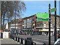
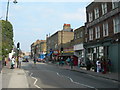
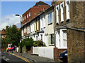
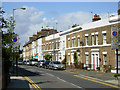
Photos of N16 0SN


Area Information
N16 0SN is a small, tightly knit residential postcode in England, home to 1,753 people. Its compact size means it is a quiet, community-focused area where daily life is shaped by proximity to local amenities and transport links. The area’s character is defined by its mix of practical living and easy access to London’s broader networks. Residents benefit from a balance of urban convenience and residential tranquillity, with no major natural or environmental constraints affecting the area. The population is predominantly adults aged 30–64, suggesting a mature, stable community. While the area is not large, its strategic location near multiple transport hubs and retail centres makes it appealing for those seeking a blend of local living and city connectivity. The absence of flood risk or protected natural sites means residents face minimal environmental challenges. For buyers, N16 0SN offers a focused, manageable area with clear advantages in connectivity and safety, though its small size means it is best suited for those prioritising accessibility over expansive space.
- Area Type
- Postcode
- Area Size
- Not available
- Population
- 1753
- Population Density
- 14024 people/km²
The property market in N16 0SN is characterised by a high proportion of rented flats, with only 34% of homes owned by residents. This suggests the area is more of a rental market than an owner-occupied one, which may influence buyer expectations. The predominance of flats indicates a focus on compact, urban living, likely catering to professionals or those prioritising convenience over larger homes. Given the area’s small size, the housing stock is limited, and buyers should consider the immediate surroundings for more options. The low home ownership rate could reflect a transient population or a lack of long-term investment in the area. For those seeking property, the market may offer competitive pricing but limited choice, requiring a strategic approach to location and proximity to amenities. The flat-dominated landscape also means buyers should assess whether the layout and size meet their needs.
House Prices in N16 0SN
No properties found in this postcode.
Energy Efficiency in N16 0SN
Living in N16 0SN offers access to a range of amenities within practical reach. The area is served by five retail outlets, including major supermarkets like Tesco Stoke Newington and Sainsburys Stoke, ensuring everyday shopping needs are met. Transport links are extensive, with five rail stations, including Rectory Road and Stoke Newington, and metro stops such as Manor House and Holloway Road. Ferry piers like Camden Lock Waterbus provide alternative travel options. For commuters, four bus routes connect to key hubs like Whipps Cross Bus Interchange and London Victoria Coach Station. The presence of these amenities fosters a convenient lifestyle, blending local convenience with city-wide accessibility. Residents can enjoy a mix of retail, transport, and leisure options without needing to travel far, enhancing the area’s appeal for those valuing practicality.
Amenities
Schools
| Rank | School | Type | Entry gender | Ages |
|---|
Explore more schools in this area
Go to Schools tabDemographics
The population of N16 0SN has a median age of 47, with the majority of residents falling within the 30–64 age range. This suggests a community of established professionals and families, rather than a younger or elderly demographic. Home ownership in the area is relatively low at 34%, indicating that a significant portion of the housing stock is rented. The predominant accommodation type is flats, which aligns with the area’s compact nature and likely urban development. The dominant ethnic group is White, though specific diversity metrics are not provided. The age profile and home ownership rate suggest a stable, long-term resident base with moderate mobility. For prospective buyers, the lower home ownership rate may imply a rental market dynamic, though the small population size means the area is not a major hub for property investment. The demographic makeup reflects a practical, functional living environment tailored to middle-aged adults.
Household Size
Accommodation Type
Tenure
Ethnic Group
Religion
Household Composition
Age
Household Deprivation
NS-SEC
Explore more demographic insights in this area
Go to Demographics tabPlanning
Planning Constraints
- Flood RiskPremium
- Ramsar Wetland SitesPremium
- Area of Outstanding Natural BeautyPremium
- Protected Nature ReservePremium
- Protected WoodlandPremium