Area Overview for N15 6SG
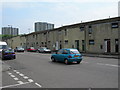
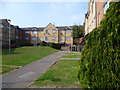
Photos of N15 6SG


Area Information
Living in N15 6SG means inhabiting a compact residential postcode with a population of 2921, where daily life is shaped by proximity to transport hubs and local amenities. This area is defined by its mix of practical living and connectivity, with residents benefiting from nearby schools, retail options, and rail links. The community is predominantly composed of adults aged 30–64, reflecting a mature demographic. While the area lacks large-scale infrastructure, its small size fosters a focused, accessible environment. Residents are likely to rely on public transport, given the low home ownership rate of 24%, suggesting a rental market with a concentration of flats. The postcode’s character is anchored by its accessibility to multiple rail stations and primary schools, making it appealing for commuters and families seeking convenience over expansive space.
- Area Type
- Postcode
- Area Size
- Not available
- Population
- 2921
- Population Density
- 13778 people/km²
The property market in N15 6SG is characterised by a low home ownership rate of 24%, indicating that the area is primarily a rental market rather than one dominated by owner-occupied properties. The accommodation type is almost exclusively flats, which aligns with the small-scale, residential nature of the postcode. This suggests a housing stock that caters to individuals or small households, with limited scope for larger family homes. For buyers, the area’s compact size and focus on rental properties mean that opportunities for purchase are likely to be limited to specific developments or conversions. The proximity to transport links may enhance the appeal of flats here, but the small footprint of the postcode means that buyers should consider the immediate surroundings for more extensive housing options.
House Prices in N15 6SG
No properties found in this postcode.
Energy Efficiency in N15 6SG
Residents of N15 6SG enjoy a range of amenities within practical reach, including retail outlets like Sainsburys Hackney, Sainsburys Harringay, and Aldi Arena. These stores cater to daily shopping needs, while rail stations such as Stamford Hill and Harringay Green Lanes offer easy access to urban centres. Ferry services at Camden Lock and London Zoo provide scenic travel options. The area’s proximity to multiple transport hubs and retail spaces supports a convenient lifestyle, though the small postcode size means that larger leisure facilities may require travel. The mix of shops, transport links, and nearby green spaces (if any) creates a balanced environment for both practicality and occasional recreation.
Amenities
Schools
Residents of N15 6SG have access to two primary schools: Stamford Hill Primary School and Tiverton Primary School, which has an Ofsted rating of satisfactory. These institutions serve the local community, providing education for younger children within walking distance of many homes. The presence of two primary schools suggests that the area is family-friendly, though the Ofsted rating for Tiverton indicates that parents may need to evaluate the quality of education more closely. For families prioritising proximity to schools, N15 6SG offers immediate access to primary education, but secondary school options would require travel beyond the immediate postcode.
| Rank | School | Type | Entry gender | Ages |
|---|
Explore more schools in this area
Go to Schools tabDemographics
The population of N15 6SG has a median age of 47, with the majority of residents falling within the 30–64 age range. This suggests a community of working-age adults, possibly with families, though the 24% home ownership rate indicates that most households are renters rather than property owners. The accommodation type is predominantly flats, reflecting a housing stock tailored to smaller or shared living arrangements. The predominant ethnic group is White, though no specific diversity metrics are provided. The relatively low home ownership rate may imply a transient population or a focus on rental properties. For buyers, this demographic profile suggests a market where demand for flats and rental properties is likely to remain stable, with little emphasis on owner-occupied homes.
Household Size
Accommodation Type
Tenure
Ethnic Group
Religion
Household Composition
Age
Household Deprivation
NS-SEC
Explore more demographic insights in this area
Go to Demographics tabPlanning
Planning Constraints
- Flood RiskPremium
- Ramsar Wetland SitesPremium
- Area of Outstanding Natural BeautyPremium
- Protected Nature ReservePremium
- Protected WoodlandPremium