Area Overview for N15 4RT
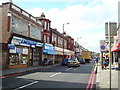
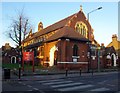
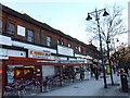
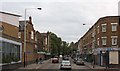
Photos of N15 4RT


Area Information
Living in N15 4RT means being part of a small, tightly knit residential cluster in north London. With a population of 2048, the area is compact but well-served by transport links and local amenities. The community here skews towards adults aged 30–64, creating a mature demographic profile. Daily life is shaped by proximity to multiple rail, metro, and bus routes, ensuring easy access to central London and beyond. The area’s housing stock is predominantly flats, reflecting its urban character. While the postcode is small, it offers a balance of practicality and connectivity, with shops, transport hubs, and green spaces within reach. For those prioritising convenience over sprawling landscapes, N15 4RT provides a functional base with minimal commute times to key destinations. However, its size means it is best suited to those seeking a compact, well-connected living environment rather than expansive suburban comforts.
- Area Type
- Postcode
- Area Size
- Not available
- Population
- 2048
- Population Density
- 12830 people/km²
The property market in N15 4RT is characterised by a low home ownership rate of 23%, indicating that the area is not primarily owner-occupied. Instead, it functions more as a rental market, with flats making up the majority of housing stock. This suggests a focus on short-term or flexible tenancies rather than long-term property investment. For buyers, this dynamic means limited availability of owner-occupied homes, with most properties likely to be available through private or social rental channels. The small size of the postcode also means that the immediate surroundings are critical for property options, as the area itself offers few standalone homes. Prospective buyers should consider the area’s urban nature and its suitability for those prioritising proximity to transport and amenities over traditional homeownership.
House Prices in N15 4RT
No properties found in this postcode.
Energy Efficiency in N15 4RT
Daily life in N15 4RT is shaped by its proximity to essential amenities. Retail options include major supermarkets like Tesco South, Sainsburys Tottenham Seven, and Iceland Tottenham, ensuring easy access to groceries and everyday essentials. The area’s transport hubs, such as Seven Sisters Station and Turnpike Lane Metro, provide swift connections to central London and beyond. For leisure, nearby ferry services like the London Zoo Waterbus Stop offer unique travel experiences. While green spaces are not explicitly mentioned, the absence of planning constraints such as AONB or protected woodlands suggests that recreational areas may be limited. Nevertheless, the concentration of shops, transport, and services within practical reach ensures a convenient, urban lifestyle with minimal need for long commutes or detours.
Amenities
Schools
| Rank | School | Type | Entry gender | Ages |
|---|
Explore more schools in this area
Go to Schools tabDemographics
The community in N15 4RT is predominantly composed of adults aged 30–64, with a median age of 47. This suggests a stable, established population with limited presence of younger families or retirees. Home ownership is low, at just 23%, indicating that most residents are likely to be renters. The accommodation type is primarily flats, reflecting the area’s urban density. The predominant ethnic group is White, though specific diversity metrics are not provided. The age profile and ownership figures suggest a population that may prioritise rental flexibility over long-term property investment. With no data on deprivation levels, it is unclear how this impacts quality of life, but the low home ownership rate could imply a reliance on rental markets or shared living arrangements.
Household Size
Accommodation Type
Tenure
Ethnic Group
Religion
Household Composition
Age
Household Deprivation
NS-SEC
Explore more demographic insights in this area
Go to Demographics tabPlanning
Planning Constraints
- Flood RiskPremium
- Ramsar Wetland SitesPremium
- Area of Outstanding Natural BeautyPremium
- Protected Nature ReservePremium
- Protected WoodlandPremium