Area Overview for N14 6NL
Photos of N14 6NL
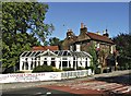
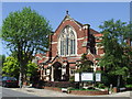
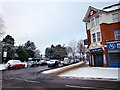
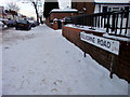


71 photos from this area
Area Information
Key information about the N14 6NL including its size, population, and administrative classification.
- Area Type
- Postcode
- Area Size
- 7680 m²
- Population
- 1875
- Population Density
- 3874 people/km²
House Prices in N14 6NL
11
Properties
£880,625
Average Sold Price
£280,000
Lowest Price
£1,670,000
Highest Price
Showing 11 properties
| Address | Type | Beds | Baths | Last Sale Price | Last Sale Date | |
|---|---|---|---|---|---|---|
| 32 Meadway, Southgate, N14 6NL | Detached | 4 | 3 | £1,375,000 | Jul 2025 | |
| 24 Meadway, Southgate, N14 6NL | Detached | 4 | 2 | £1,502,000 | Aug 2024 | |
| 38 Meadway, Southgate, N14 6NL | Detached | 4 | 2 | £1,670,000 | Apr 2023 | |
| 22 Meadway, Southgate, N14 6NL | Detached | 4 | 4 | £650,000 | Mar 2011 | |
| 30 Meadway, Southgate, N14 6NL | Detached | 4 | - | £805,000 | Sep 2010 | |
| 20 Meadway, Southgate, N14 6NL | Semi-detached | - | - | £388,000 | Jul 2002 | |
| 28 Meadway, Southgate, N14 6NL | Detached | - | - | £375,000 | Jan 1999 | |
| 34 Meadway, Southgate, N14 6NL | Semi-detached | - | - | £280,000 | Apr 1996 | |
| 36 Meadway, Southgate, N14 6NL | Semi-detached | - | - | - | - | |
| 26 Meadway, Southgate, N14 6NL | Detached | - | - | - | - |
Page 1 of 2
Energy Efficiency in N14 6NL
Amenities
Schools
| Rank | School | Type | Entry gender | Ages |
|---|
Explore more schools in this area
Go to Schools tabDemographics
Household Size
Family (3-5 people)
most common
Accommodation Type
Houses
most common
Tenure
63
majority
Ethnic Group
White
most common
Religion
N/A
most common
Household Composition
N/A
most common
Age
47
median
Adults (30-64 years)
most common
Household Deprivation
N/A
with no deprivation
NS-SEC
45
in Lower managerial occupations
Explore more demographic insights in this area
Go to Demographics tabPlanning
Planning Constraints
- Flood RiskPremium
- Ramsar Wetland SitesPremium
- Area of Outstanding Natural BeautyPremium
- Protected Nature ReservePremium
- Protected WoodlandPremium