Area Overview for N14 5DW
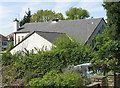
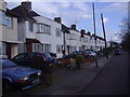
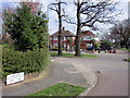
Photos of N14 5DW


Area Information
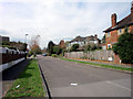
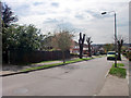
Living in N14 5DW offers a quiet, residential experience in a small cluster of homes. With a population of 1,745, the area feels intimate, balancing suburban calm with practical connectivity. The community is predominantly composed of adults aged 30–64, many of whom own their homes. This suggests a stable, long-term presence, with fewer transient residents. The area’s compact size means daily life is easy to navigate, with nearby shops, transport links, and low environmental constraints. Residents benefit from excellent broadband, rated 100 out of 100, ensuring seamless internet use for work or leisure. Safety is a key feature, with low flood risk, no protected natural areas, and a crime score of 78, indicating a secure environment. The proximity to multiple retail outlets and transport hubs like Southgate and Arnos Grove stations adds convenience, making N14 5DW appealing for those seeking a balance between accessibility and tranquillity.
- Area Type
- Postcode
- Area Size
- Not available
- Population
- 1745
- Population Density
- 7117 people/km²
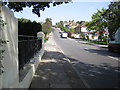
N14 5DW is primarily an owner-occupied area, with 77% of homes owned by residents rather than rented. The accommodation type is predominantly houses, which suggests a focus on family-friendly or more spacious living. This contrasts with areas dominated by flats or rental properties, where turnover is higher. The small population and limited housing stock mean the market is likely tight, with limited new developments. Buyers should consider nearby areas for broader options, though the existing stock offers stability. The high home ownership rate also implies strong community roots, which may appeal to those seeking a settled, long-term environment.
House Prices in N14 5DW
No properties found in this postcode.
Energy Efficiency in N14 5DW
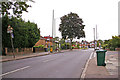
Daily life in N14 5DW is shaped by its proximity to essential amenities. Residents have access to five retail outlets, including Tesco Osidge and Asda Southgate, ensuring easy shopping for groceries and household needs. The area’s transport network is extensive, with five metro stations and five rail stations, such as New Barnet and Oakleigh Park, facilitating quick travel to nearby towns or London. While the data does not mention parks or leisure facilities, the absence of planning constraints like protected woodlands or AONB areas suggests open space may be available nearby. The combination of retail, transport, and low environmental restrictions creates a practical, convenient lifestyle, ideal for those prioritising accessibility and ease of movement.
Amenities
Schools
| Rank | School | Type | Entry gender | Ages |
|---|
Explore more schools in this area
Go to Schools tabDemographics
The community in N14 5DW is largely composed of adults aged 30–64, with a median age of 47. This suggests a mature, established population, likely with strong ties to the area. Home ownership is high at 77%, reflecting a preference for long-term residency over renting. The accommodation is predominantly houses, which aligns with the area’s residential character. The predominant ethnic group is White, though no specific diversity metrics are provided. The low population of 1,745 indicates a tightly knit community, where social interactions may be frequent. The absence of significant deprivation data means the area appears to support a stable quality of life, with no obvious barriers to access or opportunity.
Household Size
Accommodation Type
Tenure
Ethnic Group
Religion
Household Composition
Age
Household Deprivation
NS-SEC
Explore more demographic insights in this area
Go to Demographics tabPlanning
Planning Constraints
- Flood RiskPremium
- Ramsar Wetland SitesPremium
- Area of Outstanding Natural BeautyPremium
- Protected Nature ReservePremium
- Protected WoodlandPremium