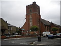
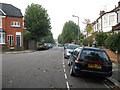
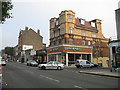
Area Overview for N12 8JL
Photos of N12 8JL


Area Information
N12 8JL is a small residential postcode area in England, home to 1667 residents. It is a compact cluster of properties, primarily flats, situated in a setting that balances suburban convenience with proximity to urban amenities. The area’s character is defined by its mature demographic, with a median age of 47 and a majority of residents aged between 30 and 64. This suggests a community of established professionals and families seeking stability. Daily life here is shaped by nearby transport hubs, including metro and rail stations, which provide easy access to London’s broader network. The presence of St Michael’s Catholic Grammar School, rated outstanding by Ofsted, adds to the appeal for families. While the area is small, it offers a mix of retail and leisure options within walking distance, ensuring residents can access essentials without long commutes. The low crime risk and absence of environmental constraints make it a practical choice for those prioritising safety and ease of living. For buyers, N12 8JL represents a focused opportunity to invest in a well-connected, low-maintenance residential environment.
- Area Type
- Postcode
- Area Size
- Not available
- Population
- 1667
- Population Density
- 9608 people/km²
The property market in N12 8JL is characterised by a 62% home ownership rate, suggesting a mix of owner-occupied and rental properties. The accommodation type is predominantly flats, which may indicate a housing stock that includes older developments or newer purpose-built schemes. Given the area’s small size, the available properties are likely limited to a few blocks or terraces, with limited scope for expansion. For buyers, this means a focus on existing stock rather than new builds. The flat-dominated market may appeal to those seeking low-maintenance living or investment opportunities in a stable, low-risk area. However, the small size of the postcode means buyers should consider nearby areas for broader options. The 62% ownership rate also implies a moderate turnover of properties, with potential for long-term value retention. Those seeking a flat in N12 8JL should weigh the benefits of proximity to transport and amenities against the limited property diversity.
House Prices in N12 8JL
No properties found in this postcode.
Energy Efficiency in N12 8JL
Life in N12 8JL is supported by a range of amenities within practical reach. Retail options include five major stores such as Tesco North, Sainsburys North, and Aldi North, ensuring residents have access to daily essentials. The area’s five metro stations, including West Finchley and Totteridge & Whetstone, provide seamless links to London’s transport system, while five rail stations like Oakleigh Park and New Barnet offer further connectivity. For leisure, the Camden Lock Waterbus and London Zoo Waterbus Stop provide unique transport options, though their use may be situational. The proximity to these amenities means residents can shop, commute, and access leisure activities without long journeys. The mix of retail, transport, and water-based options contributes to a convenient, well-served lifestyle. While the area is small, its amenities are strategically placed to meet both practical and recreational needs.
Amenities
Schools
The most notable school near N12 8JL is St Michael’s Catholic Grammar School, a primary school with an outstanding Ofsted rating. This school is a significant asset for families, offering high-quality education in a faith-based setting. The absence of secondary schools in the immediate area means parents may need to consider nearby post-primary options, but the outstanding rating at St Michael’s suggests a strong foundation for early education. The presence of a top-rated primary school enhances the area’s appeal, particularly for families prioritising academic standards. With no other schools listed in the data, the focus remains on this single institution. Its performance reflects positively on the neighbourhood’s commitment to education, though buyers should verify secondary schooling options beyond the immediate postcode.
| Rank | School | Type | Entry gender | Ages |
|---|
Explore more schools in this area
Go to Schools tabDemographics
The population of N12 8JL is 1667, with a median age of 47, indicating a mature community. The most common age group is adults aged 30–64, suggesting a balance between working professionals and families. Home ownership stands at 62%, meaning nearly two-thirds of residents own their homes, while the remaining 38% likely rent. The predominant accommodation type is flats, reflecting a housing stock that may include purpose-built blocks or converted buildings. The predominant ethnic group is White, with no specific data on diversity beyond this. This demographic profile points to a stable, long-term resident base with established roots. The age range implies a community with a mix of career-focused individuals and families, though younger or retired residents are less represented. The lack of detailed diversity metrics means the area’s cultural makeup remains largely unexplored in the data, but the figures provided offer a clear snapshot of its composition.
Household Size
Accommodation Type
Tenure
Ethnic Group
Religion
Household Composition
Age
Household Deprivation
NS-SEC
Explore more demographic insights in this area
Go to Demographics tabPlanning
Planning Constraints
- Flood RiskPremium
- Ramsar Wetland SitesPremium
- Area of Outstanding Natural BeautyPremium
- Protected Nature ReservePremium
- Protected WoodlandPremium