Area Overview for N10 3UT
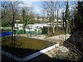
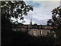
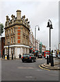
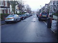
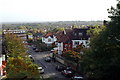
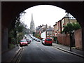
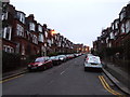
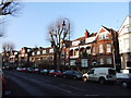
Photos of N10 3UT
Area Information
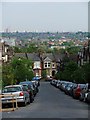
Living in N10 3UT means being part of a small, tightly knit residential cluster in north London. With a population of just 1,369, the area offers a quiet, low-density lifestyle typical of its postcode’s character. The community is predominantly composed of adults aged 30–64, with a median age of 47, suggesting a stable, mature demographic. Home ownership is high at 70%, with most properties being houses rather than flats, reflecting a suburban feel. The area is well-served by transport links, including nearby metro and rail stations, and is within reach of retail and leisure amenities. Safety is a key feature, with a crime risk score of 79, placing it below the average for London. While not a sprawling suburb, N10 3UT’s compact size means residents can access essential services without long commutes. The absence of protected natural sites or flood risks adds to its appeal, though its small scale means the housing market is limited to a handful of properties. For buyers seeking a peaceful, established neighbourhood with strong connectivity, N10 3UT offers a blend of practicality and quiet living.
- Area Type
- Postcode
- Area Size
- Not available
- Population
- 1369
- Population Density
- 8389 people/km²
The property market in N10 3UT is dominated by owner-occupied homes, with 70% of properties owned by residents rather than rented. This high home ownership rate suggests a stable, long-term community where property values may appreciate steadily. The accommodation type is primarily houses, which are more common than flats in this area. Given the postcode’s small size, the housing stock is limited to a handful of properties, making it a niche market for buyers seeking a suburban lifestyle. The absence of rental properties indicates that the area is not a hotspot for short-term lets or investment properties. For buyers, this means a focus on individual homes rather than larger developments. The compact nature of the area also means that properties are likely to be in close proximity to amenities such as schools, transport, and retail, enhancing their practicality. However, the limited number of homes may result in a competitive market for those seeking to purchase.
House Prices in N10 3UT
No properties found in this postcode.
Energy Efficiency in N10 3UT
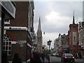
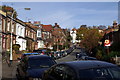
Residents of N10 3UT have access to a range of amenities within practical reach. Retail options include M&S Muswell Hill, Sainsburys Muswell, and Planet Organic Muswell, offering a mix of high-street brands and local independents. The area’s transport links also provide access to nearby parks and leisure spots, with waterbus stops connecting to London Zoo and Little Venice. Metro and rail stations like Highgate and Alexandra Palace Station make it easy to reach cultural hubs, shopping centres, and green spaces. The presence of multiple transport modes, combined with retail and leisure options, creates a lifestyle that balances convenience with the ability to explore beyond the immediate postcode. For those valuing accessibility without urban congestion, N10 3UT’s amenities and connections support a versatile daily life.
Amenities
Schools
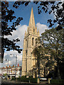
The nearest school to N10 3UT is Whittingham School, an independent institution. Independent schools are typically fee-paying, which may be a consideration for families seeking private education. While the data does not provide an Ofsted rating, the presence of an independent school suggests that the area is attractive to households prioritising educational options. However, no other schools are listed in the data, meaning families may need to look further afield for state schools or additional educational facilities. The limited number of schools in the immediate vicinity could impact convenience for parents reliant on local education. For those seeking a mix of school types, N10 3UT’s proximity to Whittingham School offers a single, notable option, though broader choices may require commuting to nearby areas.
| Rank | School | Type | Entry gender | Ages |
|---|
Explore more schools in this area
Go to Schools tabDemographics
The community in N10 3UT is predominantly composed of adults aged 30–64, with a median age of 47. This suggests a mature, settled population, likely with established careers and families. Home ownership is high at 70%, indicating a stable housing market where most residents own their properties. The area is characterised by houses rather than flats, which aligns with its suburban nature. The predominant ethnic group is White, though no specific data on diversity or deprivation is provided. The low crime risk score of 79, which is below average, implies a safe environment for residents. However, the absence of detailed socioeconomic data means it is unclear how this translates to broader quality-of-life factors such as access to services or affordability. The age profile suggests a community with a focus on long-term residency, potentially with fewer young families or students compared to other areas.
Household Size
Accommodation Type
Tenure
Ethnic Group
Religion
Household Composition
Age
Household Deprivation
NS-SEC
Explore more demographic insights in this area
Go to Demographics tabPlanning
Planning Constraints
- Flood RiskPremium
- Ramsar Wetland SitesPremium
- Area of Outstanding Natural BeautyPremium
- Protected Nature ReservePremium
- Protected WoodlandPremium