Area Overview for N1 9GE
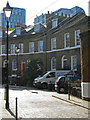
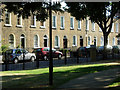
Photos of N1 9GE


Area Information
Living in N1 9GE means inhabiting a compact residential cluster in north London, where proximity to transport hubs and amenities defines daily life. With a population of 2,029, the area is small but well-connected, situated near King’s Cross and St Pancras stations. The community is predominantly adults aged 30–64, with a median age of 47, suggesting a mature, stable demographic. Flats dominate the housing stock, reflecting a rental-heavy market, though 24% of residents own their homes. The area’s appeal lies in its accessibility: major rail lines, metro stops, and ferry routes create seamless links to central London and beyond. For families, the outstanding-rated Winton Primary School is a local asset, while digital connectivity scores of 90 for broadband and 85 for mobile ensure reliable internet access. However, the high crime risk score of 1/100 necessitates caution, balancing the area’s convenience with practical safety considerations. N1 9GE is a microcosm of urban living, where proximity to transport and retail is offset by the need for vigilance.
- Area Type
- Postcode
- Area Size
- Not available
- Population
- 2029
- Population Density
- 13402 people/km²
The property market in N1 9GE is characterised by a low home ownership rate—just 24% of residents own their homes—indicating a rental-dominated landscape. Flats are the primary accommodation type, reflecting the area’s compact, urban nature. This suggests a housing stock tailored to single occupants or smaller households, with limited scope for family homes. Given the area’s proximity to major transport hubs like King’s Cross and St Pancras, properties here likely cater to commuters or professionals prioritising connectivity over space. The small population and limited housing stock mean the market is niche, with few options for buyers. Those seeking property in N1 9GE may need to consider nearby areas for more variety, though the area’s strategic location remains a key selling point for investors or renters seeking convenience over size.
House Prices in N1 9GE
No properties found in this postcode.
Energy Efficiency in N1 9GE
Residents of N1 9GE have access to a range of retail, transport, and leisure amenities within walking distance. The area is served by five retail outlets, including Waitrose Kings and Tesco Kings, providing everyday shopping convenience. Transport options are extensive, with rail, metro, and bus services linking to London’s core, while ferry stops like Camden Lock Waterbus offer alternative routes. The presence of London Kings Cross Railway Station and St Pancras International ensures easy access to national and international travel. For leisure, the nearby London Zoo Waterbus Stop and Savoy Pier hint at recreational opportunities, though specifics are limited. The area’s compact size means amenities are concentrated, creating a walkable, efficient environment. However, the lack of detailed data on parks or cultural venues leaves gaps in understanding the full lifestyle offering.
Amenities
Schools
The nearest school to N1 9GE is Winton Primary School, an outstanding-rated institution offering education for younger children. As a primary school, it serves families with children aged 4–11, though no secondary schools are listed in the data. The absence of other schools in the immediate vicinity means parents may need to consider nearby areas for secondary education. The high Ofsted rating for Winton Primary School is a significant draw for families prioritising academic standards, though the lack of diverse school types limits the range of educational options. For those relying solely on local schools, the area’s suitability depends on the specific needs of children, with proximity to transport hubs offering flexibility for commuting to other districts.
| Rank | School | Type | Entry gender | Ages |
|---|
Explore more schools in this area
Go to Schools tabDemographics
The community in N1 9GE is composed of adults aged 30–64, with a median age of 47, reflecting a settled population. Only 24% of residents own their homes, indicating a predominantly rental market, while flats are the primary accommodation type. The area’s demographic is largely White, with no data provided on other ethnic groups. The low home ownership rate suggests a transient or younger population, though the median age implies stability. The absence of specific data on deprivation or household types means the community’s socioeconomic profile remains partially opaque. However, the high concentration of adults in middle age suggests a focus on established careers and family life. The area’s small size and limited housing stock may contribute to a close-knit feel, though the lack of detailed diversity metrics limits a fuller picture of its social fabric.
Household Size
Accommodation Type
Tenure
Ethnic Group
Religion
Household Composition
Age
Household Deprivation
NS-SEC
Explore more demographic insights in this area
Go to Demographics tabPlanning
Planning Constraints
- Flood RiskPremium
- Area of Outstanding Natural BeautyPremium
- Protected Nature ReservePremium
- Protected WoodlandPremium