Area Overview for N1 2UZ
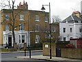
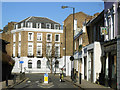
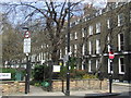
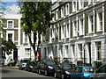
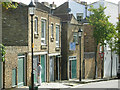
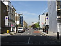
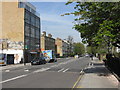
Photos of N1 2UZ


Area Information
Living in N1 2UZ means being part of a small, tightly knit residential cluster in north London. With a population of 1,861, this area is compact but offers a range of daily conveniences. The community is predominantly composed of adults aged 30–64, reflecting a mature demographic. Proximity to schools, transport hubs, and retail outlets shapes the rhythm of life here. Residents benefit from excellent connectivity, with broadband scores nearing 100 and mobile coverage rated as good. The area’s compact size means amenities are within practical reach, though the housing stock is largely flats, which influences the local character. While the population is relatively small, the density of services and infrastructure ensures a functional, if modest, urban lifestyle. The absence of significant environmental constraints, such as protected woodlands or wetlands, means development is not restricted, though the high crime risk—above average—requires attention. For those seeking a balance between accessibility and community, N1 2UZ offers a distinct slice of London’s north-eastern edge.
- Area Type
- Postcode
- Area Size
- Not available
- Population
- 1861
- Population Density
- 12996 people/km²
The property market in N1 2UZ is characterised by a low home ownership rate of 36%, suggesting that the area is more rental-focused than owner-occupied. The predominant accommodation type is flats, which aligns with the compact, urban nature of the postcode. This housing stock likely appeals to renters seeking proximity to transport and amenities, rather than long-term buyers. The small size of the area means the local property market is limited in scope, with limited scope for significant price fluctuations. Buyers considering the area should note that the housing stock is not diverse, with flats dominating. Those seeking a home here may find it more practical to view the surrounding neighbourhoods for a broader range of property types.
House Prices in N1 2UZ
No properties found in this postcode.
Energy Efficiency in N1 2UZ
The lifestyle in N1 2UZ is shaped by its proximity to retail, dining, and transport hubs. Nearby shops include Sainsburys Islington St, Budgens Barnsbury, and Waitrose Little, offering everyday essentials. The area’s transport network includes rail, metro, and ferry services, with stations like Highbury & Islington and Angel providing direct links to major destinations. While parks and leisure facilities are not explicitly listed in the data, the density of amenities suggests a focus on convenience over expansive green spaces. The mix of retail outlets and transport options means daily errands and commutes are efficient, though the area’s compact size may limit larger recreational opportunities. For residents prioritising accessibility, the combination of shops and transport makes N1 2UZ a practical choice.
Amenities
Schools
Residents of N1 2UZ have access to a cluster of primary schools, including Canonbury Infants’ School, Canonbury Junior School, William Tyndale Primary School, and Canonbury Primary School, which holds a ‘good’ Ofsted rating. William Tyndale Class Base (South) is listed as an ‘other’ school, though its specific role is not detailed. The concentration of primary schools within a short distance makes the area appealing for families, offering multiple options for early education. However, the absence of secondary schools in the immediate vicinity means parents may need to look further afield for secondary education. The presence of multiple schools with a ‘good’ rating suggests a generally strong educational offering for younger children, though the diversity of school types is limited.
| Rank | School | Type | Entry gender | Ages |
|---|
Explore more schools in this area
Go to Schools tabDemographics
The community in N1 2UZ is defined by its median age of 47, with the majority of residents falling between 30 and 64 years old. This suggests a stable, established population rather than a transient one. Home ownership is relatively low at 36%, indicating that a significant proportion of residents rent their homes. The accommodation type is predominantly flats, reflecting the area’s urban density. The predominant ethnic group is White, though specific data on diversity is not provided. The age profile and ownership figures imply a mix of long-term residents and professionals working in nearby sectors. The absence of detailed deprivation data means the quality of life implications of these demographics remain unquantified, but the presence of multiple schools and transport links suggests the area is functional for families and commuters.
Household Size
Accommodation Type
Tenure
Ethnic Group
Religion
Household Composition
Age
Household Deprivation
NS-SEC
Explore more demographic insights in this area
Go to Demographics tabPlanning
Planning Constraints
- Flood RiskPremium
- Ramsar Wetland SitesPremium
- Area of Outstanding Natural BeautyPremium
- Protected Nature ReservePremium
- Protected WoodlandPremium