Area Overview for KT6 6WF
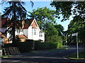
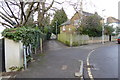
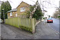
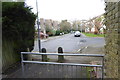
Photos of KT6 6WF


Area Information
Living in KT6 6WF offers a compact, residential experience with a population of 1,599, creating a close-knit community feel. This small postcode area is characterised by a mature demographic, with a median age of 47 and a majority of residents aged between 30 and 64. The area is predominantly owner-occupied, with 69% of homes owned by residents, and houses are the primary form of accommodation. KT6 6WF sits within easy reach of Surbiton and Kingston, offering access to local amenities, transport links, and green spaces. Residents benefit from proximity to Sainsburys Surbiton and multiple ferry piers, including Kingston Town End Pier and Ditton Island Ferry Landing, which connect to nearby towns. The area’s low crime risk and absence of environmental constraints such as protected woodlands or Areas of Outstanding Natural Beauty make it a practical choice for families and professionals. With a good Ofsted-rated primary school nearby, KT6 6WF balances convenience with a quiet, stable lifestyle.
- Area Type
- Postcode
- Area Size
- Not available
- Population
- 1599
- Population Density
- 3908 people/km²
The property market in KT6 6WF is dominated by owner-occupied homes, with 69% of properties owned by residents. This suggests a stable market with fewer rental properties, which may appeal to buyers seeking long-term investment. The area is primarily composed of houses, which are often associated with larger living spaces and gardens, catering to families or those preferring a more traditional residential setup. Given the small size of the postcode area, the housing stock is likely limited, meaning buyers may need to consider nearby areas for more options. The absence of high-rise or purpose-built housing indicates a focus on single-family homes. For those prioritising security and a mature community, KT6 6WF’s property market offers a blend of practicality and stability, though the limited size of the area may restrict availability.
House Prices in KT6 6WF
No properties found in this postcode.
Energy Efficiency in KT6 6WF
KT6 6WF offers a range of amenities within practical reach, enhancing daily life for residents. The area is served by five retail outlets, including Sainsburys Surbiton, providing essential shopping and grocery needs. Ferry piers such as Kingston Turks Pier and Ditton Island Ferry Landing connect residents to nearby waterways and towns, adding to the area’s accessibility. Rail and metro stations, including Berrylands Railway Station and Morden Tram Stop, ensure convenient travel to Kingston, Surbiton, and beyond. While the data does not specify dining or leisure venues, the presence of multiple transport and retail options suggests a lifestyle that balances convenience with a quiet, residential atmosphere. The mix of amenities supports both practical needs and the potential for exploring nearby attractions.
Amenities
Schools
The nearest school to KT6 6WF is St Matthew’s CofE Primary School, which holds a ‘good’ Ofsted rating. This school serves the local community, providing education for younger children within the area. While no secondary schools are listed in the data, the presence of a well-rated primary school is a significant draw for families. The school’s location within practical reach of residents ensures ease of access, reducing the need for long commutes. However, families requiring secondary education may need to look beyond KT6 6WF, as the data does not mention nearby secondary schools. The availability of a single primary school suggests that the area is well-suited for younger children but may require additional planning for older students.
| Rank | School | Type | Entry gender | Ages |
|---|
Explore more schools in this area
Go to Schools tabDemographics
KT6 6WF has a median age of 47, with the majority of residents falling within the 30-64 age range. This suggests a community of working-age adults and families with children. Home ownership is strong, at 69%, indicating a stable housing market. The area is predominantly composed of houses, reflecting a more traditional residential layout. The predominant ethnic group is White, though specific data on diversity or deprivation is not provided. The age profile suggests a balance between established residents and younger families, supported by the presence of a primary school. The absence of detailed data on household types or deprivation means the community’s socioeconomic composition remains less defined. However, the high home ownership rate and low crime risk imply a generally secure and settled population.
Household Size
Accommodation Type
Tenure
Ethnic Group
Religion
Household Composition
Age
Household Deprivation
NS-SEC
Explore more demographic insights in this area
Go to Demographics tabPlanning
Planning Constraints
- Flood RiskPremium
- Ramsar Wetland SitesPremium
- Area of Outstanding Natural BeautyPremium
- Protected Nature ReservePremium
- Protected WoodlandPremium