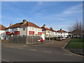
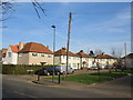
Area Overview for KT4 7XD
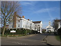
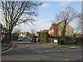
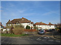
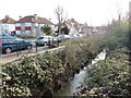
Photos of KT4 7XD


Area Information
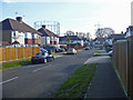
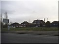
KT4 7XD is a small, tightly knit residential postcode in England with a population of 1,695. This area is defined by its compact nature, offering a quiet, community-focused environment. The demographics suggest a mature population, with a median age of 47 and most residents falling within the 30-64 age range. Home ownership is strong here, with 63% of properties occupied by their owners, indicating a stable, long-term resident base. The area’s character is shaped by its proximity to multiple transport hubs, including rail, metro, and ferry services, which provide easy access to nearby towns and cities. Daily life in KT4 7XD balances residential tranquility with practical connectivity, making it appealing to those seeking a blend of convenience and seclusion. The absence of significant environmental constraints, such as protected woodlands or flood-prone areas, further enhances its liveability. For buyers, this postcode represents a small but well-served community with a clear identity, ideal for those prioritising safety, stability, and accessibility.
- Area Type
- Postcode
- Area Size
- Not available
- Population
- 1695
- Population Density
- 7155 people/km²
The property market in KT4 7XD is dominated by owner-occupied homes, with 63% of properties held by their owners. This contrasts with areas where rental demand drives the market, suggesting a focus on long-term residency rather than transient occupancy. The accommodation type is primarily houses, which is uncommon in more densely populated urban areas. This indicates a setting that may appeal to families or individuals seeking space and privacy. Given the small size of the postcode, the housing stock is limited, and buyers should consider the proximity to nearby amenities and transport links as key factors. The absence of planning constraints, such as protected woodlands or areas of outstanding natural beauty, means development restrictions are minimal, potentially offering flexibility for future property use. For buyers, the mix of stability and accessibility makes KT4 7XD a niche but viable option for those prioritising homeownership in a low-risk environment.
House Prices in KT4 7XD
No properties found in this postcode.
Energy Efficiency in KT4 7XD
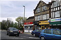
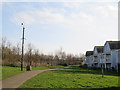
Living in KT4 7XD offers access to a range of retail and transport amenities within practical reach. Nearby supermarkets such as Iceland Worcester, Waitrose Worcester, and Sainsburys Worcester provide convenience for grocery shopping, while the proximity to rail, metro, and ferry services ensures easy access to broader networks. The area’s rail stations, including Worcester Park and Motspur Park, connect residents to London and other regional hubs, supporting both daily commutes and weekend travel. The presence of ferry options, such as Kingston Turks Pier, adds a layer of accessibility to water-based routes. These amenities contribute to a lifestyle that balances local convenience with broader opportunities. The mix of retail, transport, and proximity to green spaces—while not explicitly detailed—suggests a setting where residents can enjoy both urban and semi-rural comforts without significant travel.
Amenities
Schools
| Rank | School | Type | Entry gender | Ages |
|---|
Explore more schools in this area
Go to Schools tabDemographics
The community in KT4 7XD is predominantly composed of adults aged 30-64, with a median age of 47. This suggests a population that is largely established in careers and family life, contributing to a mature, stable demographic profile. Home ownership is high, with 63% of residents owning their properties, a figure that reflects a preference for long-term investment over rental living. The area is characterised by houses rather than flats, aligning with the typical housing stock of suburban or semi-rural settings. The predominant ethnic group is White, though specific diversity metrics are not provided. The relatively small population of 1,695 implies a close-knit community, where local interactions and services are likely to be familiar and accessible. This demographic structure supports a low crime risk, with a safety score of 70, indicating a neighbourhood where daily life is generally free from significant disruption.
Household Size
Accommodation Type
Tenure
Ethnic Group
Religion
Household Composition
Age
Household Deprivation
NS-SEC
Explore more demographic insights in this area
Go to Demographics tabPlanning
Planning Constraints
- Flood RiskPremium
- Ramsar Wetland SitesPremium
- Area of Outstanding Natural BeautyPremium
- Protected Nature ReservePremium
- Protected WoodlandPremium