Area Overview for KT2 5EF
Photos of KT2 5EF


Area Information
KT2 5EF is a small residential postcode area in England, home to around 1,817 people. It is a compact cluster of properties, likely centred around a mix of local amenities and transport links. The area’s demographic profile suggests a mature community, with a median age of 47 and most residents falling within the 30–64 age range. This suggests a stable population, possibly with families and professionals who value proximity to services. The presence of independent schools, retail outlets, and multiple transport options indicates a well-connected, practical living environment. While the area is small, it offers a balance of residential comfort and accessibility to nearby towns and cities. Residents can expect a mix of flat-based living, with a notable 44% home ownership rate, suggesting a blend of owner-occupied properties and rentals. The area’s compact nature means daily life is likely characterised by short commutes to nearby hubs, supported by rail, ferry, and metro services. For those seeking a quiet yet connected lifestyle, KT2 5EF provides a snapshot of suburban convenience with a distinct local identity.
- Area Type
- Postcode
- Area Size
- Not available
- Population
- 1817
- Population Density
- 10854 people/km²
KT2 5EF’s property market is characterised by a 44% home ownership rate, indicating that nearly half of residents rent their homes. This suggests a rental market that may be more prominent than owner-occupation, possibly due to the area’s flat-based housing stock. The accommodation type is predominantly flats, which are typically found in urban or semi-urban settings. This could imply a focus on smaller, more compact living spaces, which may appeal to professionals or families seeking manageable, centrally located properties. For buyers, the small area’s limited size means the housing stock is likely concentrated in a few key locations, with limited scope for expansion. The flat-dominated market may also mean fewer detached homes or larger properties, which could influence demand from those seeking different housing types. Given the area’s proximity to transport and amenities, properties here may be valued for their convenience rather than size, making them attractive to commuters or those prioritising accessibility over space.
House Prices in KT2 5EF
No properties found in this postcode.
Energy Efficiency in KT2 5EF
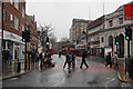
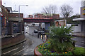
Living in KT2 5EF offers access to a range of practical amenities within easy reach. The area is served by five retail outlets, including major chains like Tesco Kingston and Sainsburys Sury, ensuring everyday shopping needs are met. For transport, residents can use five rail stations, such as Kingston Station and Berrylands Railway Station, along with ferry services at Kingston Town End Pier and Hampton Court Pier. Metro stops like Merton Park Tram Stop provide further connectivity. The presence of these services suggests a lifestyle that balances convenience with accessibility. While the data does not list specific parks or leisure facilities, the proximity to transport hubs implies easy access to larger recreational areas in nearby towns. The mix of retail, transport, and community services creates a functional environment, ideal for those prioritising practicality over expansive leisure options. The area’s compact nature ensures that essential amenities are within a short distance, reducing the need for long commutes.
Amenities
Schools
The nearest school to KT2 5EF is Educare Small School, an independent institution with a good Ofsted rating. This suggests a high standard of education for families in the area, though the absence of state schools in the data means the school mix is limited. The presence of an independent school may appeal to parents seeking private education, though it also means the area may cater more to families with the financial means to access such options. With only one school listed, the educational landscape appears focused on this single institution, which could influence family decisions about settling in the area. The good Ofsted rating indicates that the school meets or exceeds national standards in teaching and pupil outcomes, providing reassurance for prospective residents. However, the lack of additional schools, particularly state-run ones, may be a consideration for those prioritising a broader range of educational choices.
| Rank | School | Type | Entry gender | Ages |
|---|
Explore more schools in this area
Go to Schools tabDemographics
The population of KT2 5EF is 1,817, with a median age of 47. This places the area squarely in the adult demographic, with 30–64-year-olds forming the largest age group. The 44% home ownership rate indicates a significant proportion of residents rent their homes, which may reflect the area’s mix of flats and smaller properties. The predominant accommodation type is flats, suggesting a higher density of living compared to detached homes. The predominant ethnic group is White, though no specific data on diversity or deprivation levels is provided. The age profile implies a community likely focused on stability, with fewer young families or retirees compared to other areas. The 44% home ownership rate may also suggest a reliance on rental markets, which could influence local property dynamics. For quality of life, the absence of specific deprivation data means assumptions cannot be made about economic challenges, but the age distribution and housing stock suggest a practical, middle-aged population with established routines.
Household Size
Accommodation Type
Tenure
Ethnic Group
Religion
Household Composition
Age
Household Deprivation
NS-SEC
Explore more demographic insights in this area
Go to Demographics tabPlanning
Planning Constraints
- Flood RiskPremium
- Ramsar Wetland SitesPremium
- Area of Outstanding Natural BeautyPremium
- Protected Nature ReservePremium
- Protected WoodlandPremium