Area Overview for IG2 6ST
Photos of IG2 6ST


Area Information
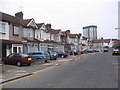
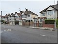
Living in IG2 6ST means being part of a tightly knit residential community in north-east London. With a population of 2163, this postcode area is small but well-served by nearby amenities and transport links. The area’s character is shaped by its proximity to Gants Hill and its mix of family homes and local services. Daily life here balances suburban comfort with urban accessibility, with schools, shops, and public transport within easy reach. The community is predominantly composed of adults aged 30–64, reflecting a mature demographic that values stability and proximity to essential services. While the area lacks large-scale commercial hubs, its compact nature ensures that residents can access necessities without long commutes. The presence of multiple schools, including Gearies Primary School with an outstanding Ofsted rating, underscores the area’s appeal to families. IG2 6ST is not a place for those seeking sprawling estates but offers a focused, practical lifestyle for those prioritising convenience and connectivity.
- Area Type
- Postcode
- Area Size
- Not available
- Population
- 2163
- Population Density
- 10650 people/km²
The property market in IG2 6ST is characterised by a 48% home ownership rate, with houses being the predominant accommodation type. This suggests a focus on family homes rather than high-density housing, which is typical of suburban areas. The relatively low home ownership percentage implies that a significant portion of the housing stock is rented, possibly attracting a mix of long-term residents and commuters. Given the area’s small size, the housing stock is likely limited, making it a niche market for buyers seeking proximity to local amenities and transport. The presence of multiple schools and retail options nearby may enhance the appeal of properties here, particularly for families. However, the compact nature of the area means that buyers should consider the immediate surroundings for additional housing options. The market is unlikely to cater to speculative investment, given the mature demographic and the absence of large-scale development projects.
House Prices in IG2 6ST
No properties found in this postcode.
Energy Efficiency in IG2 6ST
Residents of IG2 6ST enjoy a range of amenities within easy reach, including retail outlets like Tesco Gants, Sainsburys Gants Hill, and Iceland Gants, which cater to everyday shopping needs. The area’s proximity to Gants Hill Station and multiple rail links facilitates access to larger urban centres, while the nearby London City Airport adds to its connectivity. For leisure, the Woolwich Ferry services provide water-based travel options, though no specific parks or recreational spaces are listed in the data. The presence of multiple schools, combined with retail and transport hubs, creates a self-contained lifestyle that balances convenience with suburban tranquillity. While the area lacks large-scale leisure facilities, its compact nature ensures that residents can access essential services without long journeys, contributing to a practical, community-oriented way of life.
Amenities
Schools
Residents of IG2 6ST have access to a range of educational institutions, including state and independent schools. Gearies Infants’ School and Gearies Junior School provide primary education, with the latter holding an outstanding Ofsted rating. This highlights the area’s commitment to quality education for younger children. For those seeking alternative options, Abeng International Independent School offers a private education model. The presence of multiple primary schools suggests a strong focus on early education, though no secondary schools are listed in the data. Families may need to look beyond the immediate postcode for secondary schooling, but the availability of high-rated primaries is a significant draw. The mix of school types allows parents to choose between state and independent education, catering to different priorities and budgets.
| Rank | School | Type | Entry gender | Ages |
|---|
Explore more schools in this area
Go to Schools tabDemographics
The population of IG2 6ST has a median age of 47, with the majority of residents falling within the 30–64 age range. This suggests a community of established professionals and families, rather than a transient or youthful demographic. Home ownership stands at 48%, indicating a mix of owner-occupied properties and rental homes. The accommodation type is predominantly houses, which aligns with the area’s residential character. The predominant ethnic group is Asian_total, reflecting a culturally diverse community. While no specific deprivation data is provided, the age profile and housing stock suggest a stable, middle-income demographic. The presence of independent schools like Abeng International Independent School alongside state primaries indicates a range of educational preferences, which may cater to both local and broader regional families. The community’s maturity and diversity contribute to a distinct social fabric, though the small population size means interactions are likely to be more personal and familiar.
Household Size
Accommodation Type
Tenure
Ethnic Group
Religion
Household Composition
Age
Household Deprivation
NS-SEC
Explore more demographic insights in this area
Go to Demographics tabPlanning
Planning Constraints
- Flood RiskPremium
- Ramsar Wetland SitesPremium
- Area of Outstanding Natural BeautyPremium
- Protected Nature ReservePremium
- Protected WoodlandPremium