Area Overview for IG1 2AP
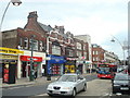
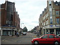
Photos of IG1 2AP


Area Information
Living in IG1 2AP offers a compact, residential experience in a small cluster of homes serving a population of 1705. This postcode sits within a practical reach of Ilford’s amenities, balancing suburban tranquillity with easy access to transport hubs. The area’s character is shaped by its proximity to Ilford Station and nearby rail links, making it a convenient base for commuters. With a median age of 47 and a majority of residents aged 30-64, the community leans towards established families and professionals. The presence of retail outlets like Iceland Ilford and Sainsburys Ilford ensures daily needs are met locally. While the area lacks natural reserves or protected landscapes, its connectivity to London City Airport and Woolwich Ferry services adds to its practical appeal. Broadband scores are excellent, supporting remote work, while crime rates sit at an average level. For buyers seeking a modest, functional living space with reliable transport links, IG1 2AP provides a straightforward, no-frills option.
- Area Type
- Postcode
- Area Size
- Not available
- Population
- 1705
- Population Density
- 10944 people/km²
The property market in IG1 2AP is defined by its small size and focus on houses, which are the predominant accommodation type. With 40% of residents owning their homes, the area is not heavily dominated by rentals, though the relatively low population suggests limited housing stock. This makes it a niche market for buyers seeking individual properties rather than high-density developments. The presence of houses may appeal to those prioritising space over proximity to city centres. However, the area’s limited size means buyers must consider nearby zones for broader options. The market likely caters to professionals and families valuing stability, with property values influenced by transport links and local amenities. For investors, the balance between owner-occupation and rentals could present opportunities, though the small footprint may restrict scalability.
House Prices in IG1 2AP
No properties found in this postcode.
Energy Efficiency in IG1 2AP
Residents of IG1 2AP have access to a range of amenities within walking or short transit distance. Retail options include Iceland Ilford, Sainsburys Ilford, and Lidl High, ensuring grocery and daily shopping needs are met. The area’s transport links are a key feature, with five rail stations, three metro stops, and ferry access at Woolwich Pier, facilitating travel to London’s business districts and beyond. While parks and leisure facilities are not explicitly listed, the proximity to Woolwich’s cultural sites and London’s green spaces suggests opportunities for recreation. The presence of multiple transport hubs and retail centres creates a convenient, functional lifestyle, though the area’s small size means social or cultural amenities are limited to nearby towns.
Amenities
Schools
| Rank | School | Type | Entry gender | Ages |
|---|
Explore more schools in this area
Go to Schools tabDemographics
The community in IG1 2AP is predominantly composed of adults aged 30-64, with a median age of 47. This suggests a stable, mature population, likely with established careers and family structures. Home ownership stands at 40%, indicating a mix of owner-occupied properties and rental units. The area’s accommodation type is primarily houses, which is uncommon in densely populated zones but aligns with its small, residential nature. The predominant ethnic group is Asian_total, reflecting a culturally diverse demographic. While deprivation data is not provided, the combination of home ownership and age profile suggests a community with moderate economic stability. The absence of specific data on household types or income levels means assumptions about lifestyle diversity must remain cautious. However, the presence of retail and transport amenities implies accessibility for a range of needs.
Household Size
Accommodation Type
Tenure
Ethnic Group
Religion
Household Composition
Age
Household Deprivation
NS-SEC
Explore more demographic insights in this area
Go to Demographics tabPlanning
Planning Constraints
- Flood RiskPremium
- Ramsar Wetland SitesPremium
- Area of Outstanding Natural BeautyPremium
- Protected Nature ReservePremium
- Protected WoodlandPremium