Area Overview for HA9 0HG
Photos of HA9 0HG


Area Information
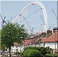
HA9 0HG is a small residential postcode in England, home to around 3,191 people. It is a compact area characterised by a mix of flats and a young demographic, with the majority of residents aged 15–29. This makes it a dynamic, youthful community, often frequented by students and early-career professionals. The area’s proximity to Wembley Stadium and major transport hubs like Wembley Park Station means daily life is conveniently linked to both leisure and employment opportunities. Retail options such as Costco Wembley and Co-op Wembley are within easy reach, while the nearby Michaela Community School, rated outstanding by Ofsted, serves as a focal point for families. Despite its small size, HA9 0HG offers a balance of urban convenience and accessible green spaces, with nearby waterbus stops connecting to London Zoo and Kew Gardens. The area’s compact nature means residents can navigate it on foot or by bike, making it ideal for those prioritising connectivity and a vibrant, active lifestyle.
- Area Type
- Postcode
- Area Size
- Not available
- Population
- 3191
- Population Density
- 4799 people/km²
HA9 0HG’s property market is defined by its low home ownership rate of 35%, indicating that the majority of housing is rented. Flats are the predominant accommodation type, reflecting the area’s suitability for younger residents seeking compact, manageable living spaces. This focus on rental properties suggests limited opportunities for long-term homeownership, particularly for those prioritising property investment. The small size of the postcode means the housing stock is concentrated, with limited scope for expansion. For buyers, this presents challenges: the market is not geared toward owner-occupiers, and competition for available flats may be fierce. However, the proximity to transport links and amenities like Wembley Stadium could offset this, making HA9 0HG appealing to those prioritising location over property growth potential. Prospective buyers should consider the area’s transient nature and the likelihood of encountering rental-focused developments.
House Prices in HA9 0HG
No properties found in this postcode.
Energy Efficiency in HA9 0HG
HA9 0HG offers a range of amenities within practical reach, blending retail, transport, and leisure. Retail options include Costco Wembley, Co-op Wembley, and Amazon Fresh, catering to both everyday needs and convenience shopping. The area’s proximity to Wembley Stadium and nearby stations makes it a hub for events and entertainment. For leisure, waterbus stops like Little Venice and Kew Pier provide access to riverside routes and attractions such as London Zoo. Parks and open spaces are not explicitly listed in the data, but the area’s transport links to green spaces suggest opportunities for outdoor activities. The mix of retail, transport, and event-based amenities creates a lifestyle that balances urban convenience with recreational options, ideal for those valuing accessibility and variety in daily life.
Amenities
Schools
The nearest school to HA9 0HG is Michaela Community School, an academy with an Ofsted rating of outstanding. This school serves the area’s young population, offering high-quality education that attracts families seeking excellence in schooling. The presence of a top-rated academy underscores the area’s appeal to parents prioritising academic standards. While no other schools are listed in the data, the proximity to Wembley and surrounding transport links suggests additional educational options may be accessible within a short commute. For families, the combination of an outstanding school and urban convenience makes HA9 0HG a viable choice, though the small postcode size means school catchment areas may be limited. The single listed school highlights the need for residents to consider broader regional options for schooling.
| Rank | School | Type | Entry gender | Ages |
|---|
Explore more schools in this area
Go to Schools tabDemographics
The population of HA9 0HG is heavily skewed towards young adults, with a median age of 22 and 15–29-year-olds comprising the most common age group. This reflects a community shaped by students, graduates, and young professionals. Home ownership is relatively low at 35%, indicating that the area is predominantly a rental market. The accommodation type is largely flats, which aligns with the needs of younger residents seeking affordable, flexible housing. The predominant ethnic group is White, though specific diversity metrics are not provided. The age profile suggests a transient population, with limited presence of older adults or families with young children. This demographic structure influences local amenities, which cater more to individual needs than to long-term family living. The area’s youthfulness also means community dynamics are often centred around shared interests and social networks rather than established neighbourhood traditions.
Household Size
Accommodation Type
Tenure
Ethnic Group
Religion
Household Composition
Age
Household Deprivation
NS-SEC
Explore more demographic insights in this area
Go to Demographics tabPlanning
Planning Constraints
- Flood RiskPremium
- Ramsar Wetland SitesPremium
- Area of Outstanding Natural BeautyPremium
- Protected Nature ReservePremium
- Protected WoodlandPremium