Area Overview for HA4 9QH
Photos of HA4 9QH
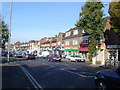


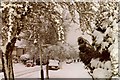
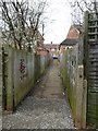
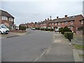
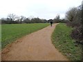

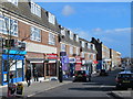
60 photos from this area
Area Information
Key information about the HA4 9QH including its size, population, and administrative classification.
- Area Type
- Postcode
- Area Size
- 5231 m²
- Population
- 1777
- Population Density
- 6429 people/km²
House Prices in HA4 9QH
16
Properties
£324,091
Average Sold Price
£94,000
Lowest Price
£535,000
Highest Price
Showing 16 properties
| Address | Type | Beds | Baths | Last Sale Price | Last Sale Date | |
|---|---|---|---|---|---|---|
| 65 Castleton Road, Ruislip, HA4 9QH | Retail | 3 | 1 | £515,000 | Oct 2022 | |
| 79 Castleton Road, Ruislip, HA4 9QH | house | - | - | £535,000 | Dec 2020 | |
| 75 Castleton Road, Ruislip, HA4 9QH | Terraced | 5 | 2 | £530,000 | Jul 2020 | |
| 57 Castleton Road, Ruislip, HA4 9QH | Semi-detached | 3 | 1 | £480,000 | Dec 2019 | |
| 77 Castleton Road, Ruislip, HA4 9QH | Terraced | 4 | 2 | £280,000 | Nov 2010 | |
| 81 Castleton Road, Ruislip, HA4 9QH | house | - | - | £304,000 | Aug 2010 | |
| 83 Castleton Road, Ruislip, HA4 9QH | house | - | - | £330,000 | Apr 2007 | |
| 69 Castleton Road, Ruislip, HA4 9QH | Semi-detached | 4 | 2 | £280,000 | Mar 2004 | |
| 71 Castleton Road, Ruislip, HA4 9QH | house | - | - | £110,000 | Jun 1998 | |
| 73 Castleton Road, Ruislip, HA4 9QH | Terraced | 3 | 1 | £94,000 | Apr 1998 |
Page 1 of 2
Energy Efficiency in HA4 9QH
Amenities
Schools
| Rank | School | Type | Entry gender | Ages |
|---|
Explore more schools in this area
Go to Schools tabDemographics
Household Size
Family (3-5 people)
most common
Accommodation Type
Houses
most common
Tenure
78
majority
Ethnic Group
White
most common
Religion
N/A
most common
Household Composition
N/A
most common
Age
47
median
Adults (30-64 years)
most common
Household Deprivation
N/A
with no deprivation
NS-SEC
42
in Lower managerial occupations
Explore more demographic insights in this area
Go to Demographics tabPlanning
Planning Constraints
- Flood RiskPremium
- Ramsar Wetland SitesPremium
- Area of Outstanding Natural BeautyPremium
- Protected Nature ReservePremium
- Protected WoodlandPremium