Area Overview for HA3 8RG
Photos of HA3 8RG
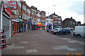
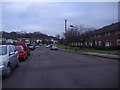
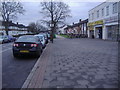

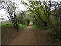
57 photos from this area
Area Information
Key information about the HA3 8RG including its size, population, and administrative classification.
- Area Type
- Postcode
- Area Size
- 1.0 hectares
- Population
- 2200
- Population Density
- 8076 people/km²
House Prices in HA3 8RG
48
Properties
£199,773
Average Sold Price
£20,775
Lowest Price
£370,000
Highest Price
Showing 48 properties
| Address | Type | Beds | Baths | Last Sale Price | Last Sale Date | |
|---|---|---|---|---|---|---|
| 332 Kenton Lane, Harrow Weald, HA3 8RG | Maisonette | 2 | 1 | £370,000 | Jul 2025 | |
| 394 Kenton Lane, Harrow Weald, HA3 8RG | Maisonette | 3 | 1 | £294,000 | Feb 2020 | |
| 376 Kenton Lane, Harrow Weald, HA3 8RG | Flat | - | - | £160,000 | Sep 2015 | |
| 338 Kenton Lane, Harrow Weald, HA3 8RG | Maisonette | - | - | £205,000 | Sep 2011 | |
| 386 Kenton Lane, Harrow Weald, HA3 8RG | Flat | 3 | 1 | £249,950 | May 2008 | |
| 334 Kenton Lane, Harrow Weald, HA3 8RG | Maisonette | 2 | 1 | £190,000 | Jul 2006 | |
| 384 Kenton Lane, Harrow Weald, HA3 8RG | Maisonette | - | - | £179,000 | Apr 2005 | |
| 340 Kenton Lane, Harrow Weald, HA3 8RG | Flat | - | - | £174,000 | Aug 2003 | |
| 350 Kenton Lane, Harrow Weald, HA3 8RG | Flat | - | - | £155,000 | Feb 2003 | |
| 344 Kenton Lane, Harrow Weald, HA3 8RG | Flat | 2 | - | £20,775 | Jan 2002 |
Page 1 of 5
Energy Efficiency in HA3 8RG
Amenities
Schools
| Rank | School | Type | Entry gender | Ages |
|---|
Explore more schools in this area
Go to Schools tabDemographics
Household Size
Family (3-5 people)
most common
Accommodation Type
Houses
most common
Tenure
67
majority
Ethnic Group
asian_total
most common
Religion
N/A
most common
Household Composition
N/A
most common
Age
47
median
Adults (30-64 years)
most common
Household Deprivation
N/A
with no deprivation
NS-SEC
31
in Lower managerial occupations
Explore more demographic insights in this area
Go to Demographics tabPlanning
Planning Constraints
- Flood RiskPremium
- Ramsar Wetland SitesPremium
- Area of Outstanding Natural BeautyPremium
- Protected Nature ReservePremium
- Protected WoodlandPremium