Area Overview for HA3 5DD
Photos of HA3 5DD


Area Information
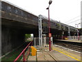
HA3 5DD is a small residential postcode area in England, home to around 2,632 people. Its compact size means it is a tightly knit community, with a focus on practical living. The area is characterised by a mix of flats, reflecting its housing stock, and is primarily occupied by adults aged 30 to 64. This demographic suggests a mature, stable population, likely drawn to the area’s proximity to transport links and retail hubs. Residents benefit from nearby amenities, including five retail outlets such as Asda Wealdstone and Tesco Harrow, as well as multiple rail and metro stations. The area’s connectivity is strong, with broadband and mobile scores of 84 and 85 respectively, supporting both daily use and remote work. While the postcode lacks natural beauty designations, it offers a straightforward, functional lifestyle. For those seeking a manageable, well-serviced environment, HA3 5DD provides a base with practical advantages, though its smaller scale means it is best suited to those prioritising convenience over expansive surroundings.
- Area Type
- Postcode
- Area Size
- Not available
- Population
- 2632
- Population Density
- 10346 people/km²
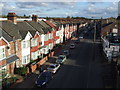
HA3 5DD’s property market is dominated by flats, with home ownership at 45%. This suggests a rental market skewed towards tenants, as fewer than half of properties are owner-occupied. The small size of the postcode means housing stock is limited, and buyers may find competition for available units. The prevalence of flats indicates a focus on high-density living, which suits those prioritising proximity to transport and amenities over larger homes. For buyers, this dynamic means limited choice in property types, with flats being the primary option. The area’s compact nature also means that immediate surroundings, such as nearby postcode clusters, may offer more varied housing stock. Potential buyers should consider the implications of a rental-heavy market, including potential price fluctuations and the need for flexibility in property searches.
House Prices in HA3 5DD
No properties found in this postcode.
Energy Efficiency in HA3 5DD
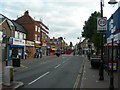
HA3 5DD’s lifestyle is defined by its practical amenities, with five retail outlets including Asda Wealdstone and Iceland Wealdstone providing everyday shopping needs. The presence of multiple rail and metro stations ensures easy access to broader urban networks, supporting both work and leisure. While the area lacks dedicated parks or leisure facilities, its proximity to transport hubs allows residents to explore nearby green spaces or cultural venues. The inclusion of RAF Northolt, though not a civilian airport, highlights the area’s strategic location. For daily life, the combination of retail, transport, and digital connectivity offers convenience, though the absence of leisure amenities means residents may need to venture further for recreation. The area’s character is one of efficiency, prioritising accessibility over expansive recreational options.
Amenities
Schools
The nearest school to HA3 5DD is Marlborough Primary School, a primary institution with an Ofsted rating of ‘good’. This provides a reliable option for families with young children, though the area lacks secondary schools or further education institutions. The presence of a single primary school suggests that parents may need to look beyond the immediate postcode for secondary education. The school’s rating indicates a satisfactory standard of teaching and facilities, but the absence of other school types limits options for older children. For families requiring a full range of educational stages, proximity to additional schools in adjacent areas may be necessary. The single school in the vicinity reflects the area’s smaller scale, making it more suited to those with children in primary education rather than those needing a comprehensive school network.
| Rank | School | Type | Entry gender | Ages |
|---|
Explore more schools in this area
Go to Schools tabDemographics
The population of HA3 5DD has a median age of 47, with the majority of residents falling within the 30-64 age range. This suggests a community of established adults, likely with families or long-term tenure in the area. Home ownership accounts for 45% of properties, indicating that the area is more rental-focused than owner-occupied. The predominant accommodation type is flats, which aligns with the compact nature of the postcode. The most common ethnic group is Asian, reflecting a culturally distinct demographic profile. This composition influences the social fabric of the area, with community interactions likely centred around shared spaces and local amenities. The absence of specific deprivation data means quality of life is inferred from available services and infrastructure. With no protected natural sites nearby, the area’s character is defined by its residential density and accessibility to urban conveniences rather than rural landscapes.
Household Size
Accommodation Type
Tenure
Ethnic Group
Religion
Household Composition
Age
Household Deprivation
NS-SEC
Explore more demographic insights in this area
Go to Demographics tabPlanning
Planning Constraints
- Flood RiskPremium
- Ramsar Wetland SitesPremium
- Area of Outstanding Natural BeautyPremium
- Protected Nature ReservePremium
- Protected WoodlandPremium