Area Overview for HA1 4WG
Photos of HA1 4WG


Area Information
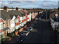
HA1 4WG is a small residential postcode in England, home to 2,632 people. It is a compact area where daily life is shaped by its proximity to transport hubs and retail centres. The community here skews towards adults aged 30–64, reflecting a mature demographic with established routines. While the area lacks large-scale amenities, its strategic location offers practical access to nearby stations, shops, and schools. The postcode covers a tightly knit cluster of properties, predominantly flats, which suggests a mix of long-term residents and renters. Living in HA1 4WG means navigating a balance between urban convenience and the constraints of a smaller, less sprawling environment. The area’s character is defined by its accessibility to major transport routes, including multiple rail and metro stops, which make commuting to nearby cities like London feasible. For those prioritising proximity to retail and transport over expansive green spaces, HA1 4WG provides a functional, if modest, base for everyday living.
- Area Type
- Postcode
- Area Size
- Not available
- Population
- 2632
- Population Density
- 10346 people/km²
The property market in HA1 4WG is characterised by a 45% home ownership rate, meaning the majority of residents are renters. This suggests the area functions more as a rental market than an owner-occupied one, which could affect long-term investment potential for buyers. The accommodation type is predominantly flats, indicating a housing stock that is likely older and more densely packed. This aligns with the area’s small size and the presence of nearby retail and transport hubs, which may cater to tenants seeking convenience over spacious living. For buyers, the limited number of owner-occupied properties and the focus on flats may mean competition is higher for those seeking to purchase. The immediate surroundings likely offer similar housing stock, reinforcing the area’s role as a practical, if limited, option for those prioritising accessibility over property diversity.
House Prices in HA1 4WG
Showing 1 properties
| Address | Type | Beds | Baths | Last Sale Price | Last Sale Date | |
|---|---|---|---|---|---|---|
| Flat 22, Soulier Apartments, 12 Calotype Lane, Harrow, HA1 4WG | Flat | 1 | 1 | - | - |
Energy Efficiency in HA1 4WG
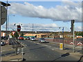
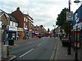
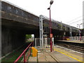
The lifestyle in HA1 4WG is shaped by its proximity to retail and transport hubs. Residents have access to major supermarkets like Asda Wealdstone and Tesco Harrow, which provide essential shopping needs within walking or short driving distance. The area’s rail and metro connections, including Harrow & Wealdstone Station and Northwick Park Station, facilitate easy travel to nearby cities and suburbs. While there are no named parks or leisure facilities listed, the presence of an airport nearby—RAF Northolt—adds a distinct local character. The concentration of retail and transport options means daily life revolves around convenience rather than expansive recreational spaces. For those prioritising practicality over sprawling amenities, HA1 4WG offers a compact, functional environment where essentials are within reach.
Amenities
Schools
The nearest school to HA1 4WG is Marlborough Primary School, which serves the local community with a primary education offering. Its Ofsted rating of 'good' indicates a satisfactory standard of teaching and facilities, though it is not among the highest-performing schools in the region. The absence of secondary schools in the immediate vicinity means families may need to look further afield for secondary education, which could impact the area’s appeal to those with older children. The single primary school available reflects the modest scale of HA1 4WG, where educational options are limited to basic needs rather than comprehensive provision. This may be a consideration for parents prioritising a broader range of school choices, though the existing school provides a functional solution for younger families.
| Rank | School | Type | Entry gender | Ages |
|---|
Explore more schools in this area
Go to Schools tabDemographics
The population of HA1 4WG has a median age of 47, with the majority of residents falling within the 30–64 age range. This suggests a community of working-age adults and older individuals, rather than a family-heavy demographic. Home ownership stands at 45%, indicating that nearly half of residents rent their homes. The accommodation type is predominantly flats, which aligns with the area’s compact layout and likely urban planning. The predominant ethnic group is Asian_total, reflecting a specific cultural composition that influences local social dynamics. While no deprivation data is provided, the high proportion of renters and the age profile suggest a population that may be more economically stable than transient. The absence of significant youth or elderly populations implies a community focused on maintaining established lifestyles rather than accommodating growing families or retirement needs.
Household Size
Accommodation Type
Tenure
Ethnic Group
Religion
Household Composition
Age
Household Deprivation
NS-SEC
Explore more demographic insights in this area
Go to Demographics tabPlanning
Planning Constraints
- Flood RiskPremium
- Ramsar Wetland SitesPremium
- Area of Outstanding Natural BeautyPremium
- Protected Nature ReservePremium
- Protected WoodlandPremium