Area Overview for HA0 1BW
Photos of HA0 1BW

Area Information
HA0 1BW is a compact residential postcode in England, covering just 8,755 square metres and home to 1,758 residents. Its high population density — 200,793 people per square kilometre — reflects a tightly packed community, typical of urban or semi-urban settings. This area is defined by its small-scale living, where proximity to amenities and transport hubs is a key feature. The demographic profile suggests a mature population, with a median age of 47 and a majority of residents aged 30–64. The area is predominantly home to owner-occupied houses, with 64% of properties in private ownership. While the data does not specify local landmarks or historical context, its strategic location near multiple transport nodes and retail outlets positions it as a practical choice for those prioritising connectivity and convenience. Living here means navigating a densely populated environment, but with access to essential services within walking or short transit distance. The area’s compact nature ensures that daily life is centred around nearby shops, schools, and transport links, making it ideal for those seeking a balanced blend of urban accessibility and residential comfort.
- Area Type
- Postcode
- Area Size
- 8755 m²
- Population
- 1758
- Population Density
- 9707 people/km²
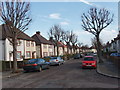
HA0 1BW is characterised by a housing stock that is predominantly owner-occupied, with 64% of properties in private hands. The accommodation type is exclusively houses, not flats or apartments, suggesting a more traditional, family-focused residential market. Given the area’s small size — just 8,755 square metres — the housing stock is limited, which may make the property market competitive. The high population density and concentration of houses imply that properties are likely to be in close proximity to one another, with little scope for expansion. For buyers, this means a focus on existing homes rather than new developments. The predominance of owner-occupation suggests that the area may appeal to those seeking long-term stability, though the small size of the postcode means that buyers should consider nearby areas for broader options. The absence of rental data means the market’s balance between owner-occupation and rental demand is unclear, but the figures provided indicate a community with a strong emphasis on home ownership.
House Prices in HA0 1BW
Showing 33 properties
| Address | Type | Beds | Baths | Last Sale Price | Last Sale Date | |
|---|---|---|---|---|---|---|
| 82 Manor Farm Road, Wembley, HA0 1BW | Terraced | 3 | 2 | £610,000 | Apr 2024 | |
| 76 Manor Farm Road, Wembley, HA0 1BW | Terraced | 6 | 2 | £182,000 | Oct 2023 | |
| 74 Manor Farm Road, Wembley, HA0 1BW | house | - | - | £635,000 | Aug 2022 | |
| 104 Manor Farm Road, Wembley, HA0 1BW | house | - | - | £485,000 | Jan 2021 | |
| 48 Manor Farm Road, Wembley, HA0 1BW | Semi-detached | 4 | - | £510,000 | Mar 2020 | |
| 96 Manor Farm Road, Wembley, HA0 1BW | house | - | - | £225,000 | Oct 2015 | |
| 56 Manor Farm Road, Wembley, HA0 1BW | Terraced | - | - | £350,000 | Dec 2014 | |
| 80 Manor Farm Road, Wembley, HA0 1BW | Terraced | 1 | 2 | £230,000 | Dec 2008 | |
| 88 Manor Farm Road, Wembley, HA0 1BW | Terraced | 4 | 2 | £285,000 | May 2008 | |
| 58 Manor Farm Road, Wembley, HA0 1BW | house | - | - | £266,500 | Oct 2006 |
Energy Efficiency in HA0 1BW
Living in HA0 1BW offers access to a range of amenities within practical reach. The area is surrounded by five retail outlets, including major supermarkets like Sainsburys Alperton and Asda Alperton, ensuring daily shopping needs are met without long journeys. For transport, residents have five metro stations, five rail stations, and ferry options like Kew Pier, providing multiple routes for commuting or leisure travel. The presence of RAF Northolt airport adds to the area’s connectivity, though its use is likely limited to specific purposes. The density of amenities suggests a convenience-focused lifestyle, where essentials are within walking or short transit distance. The mix of retail, transport, and water-based travel options creates a dynamic environment, ideal for those who value accessibility and variety. While the data does not specify parks or leisure facilities, the proximity to multiple transport hubs and retail centres implies a lifestyle centred around urban convenience and efficient movement.
Amenities
Schools
The nearest school to HA0 1BW is Vicar’s Green Primary School, which holds an outstanding Ofsted rating. This indicates a high standard of education for young children, with a focus on academic and developmental outcomes. As a primary school, it serves the needs of families with younger children, offering a foundation for early education. The data does not mention secondary schools or other educational institutions in the area, but the presence of an outstanding primary school is a significant draw for families prioritising quality education. The school’s rating suggests that it may have strong facilities, staff qualifications, and student performance metrics. For parents, this means a reliable local option for their children’s schooling, though further research would be needed to determine if secondary education is accessible within the same area or requires commuting.
| Rank | School | Type | Entry gender | Ages |
|---|
Explore more schools in this area
Go to Schools tabDemographics
The population of HA0 1BW is predominantly adults aged 30–64, with a median age of 47, indicating a mature, stable community. Home ownership is strong, with 64% of residents living in their own homes, a figure that suggests long-term residency and economic security. The accommodation type is primarily houses, not flats or apartments, which aligns with a more traditional, family-oriented housing stock. The predominant ethnic group is listed as Asian_total, though no further breakdown is provided. This demographic profile implies a community with established social networks and possibly a focus on intergenerational living. The high population density — 200,793 people per square kilometre — means the area is intensely populated, which can influence local services and infrastructure. While no specific data on deprivation is given, the combination of high home ownership and a mature population may indicate a relatively affluent or stable socioeconomic environment.
Household Size
Accommodation Type
Tenure
Ethnic Group
Religion
Household Composition
Age
Household Deprivation
NS-SEC
Explore more demographic insights in this area
Go to Demographics tabPlanning
Planning Constraints
- Flood RiskPremium
- Ramsar Wetland SitesPremium
- Area of Outstanding Natural BeautyPremium
- Protected Nature ReservePremium
- Protected WoodlandPremium