Area Overview for Waltham Forest
Photos of Waltham Forest


Area Information
Living in Waltham Forest offers a blend of urban convenience and community character. Covering 28.9 km², this built-up area in England is home to 172,492 residents, creating a dense yet compact environment. The area’s population density of 5,966 people per square kilometre reflects a mix of established neighbourhoods and evolving housing stock. Daily life here is shaped by proximity to transport hubs, retail centres, and a range of educational facilities. Waltham Forest’s appeal lies in its accessibility to London’s broader infrastructure, with multiple rail and metro stations within reach. While the median age of 70 suggests a mature demographic, the area remains active with amenities like nurseries, primary schools, and retail outlets. Residents benefit from a well-connected transport network, including stations such as Walthamstow Central and Snaresbrook, which link to central London. The presence of broadband rated 96/100 ensures reliable digital connectivity, supporting both work and leisure. For those considering homes in Waltham Forest, the balance of practicality and community amenities makes it a viable choice for families and professionals alike.
- Area Type
- Built Up Area 250
- Area Size
- 28.9 km²
- Population
- 172492
- Population Density
- 5966 people/km²
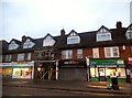
Waltham Forest’s lifestyle is shaped by its proximity to retail, dining, and leisure options. Notable shops include Budgens Walthamstow, Tesco Wood, and Tesco Walthamstow, providing everyday essentials. The area’s transport links also grant access to London’s broader amenities, from cultural attractions to dining venues. While specific parks or leisure facilities are not detailed in the data, the presence of multiple stations and ferry piers suggests opportunities for recreation and socialising. The mix of retail and transport options supports a convenient daily life, with easy access to both local services and wider urban offerings. For residents, the balance of practical amenities and connectivity creates a functional environment, ideal for those prioritising accessibility over expansive green spaces. The area’s character is defined by its role as a hub within London’s transport network, offering convenience without sacrificing proximity to urban life.
Amenities
Schools
Waltham Forest offers a range of educational institutions, including Woodford County High School, a primary school with an Ofsted rating of ‘good’. This rating indicates a school meeting standards in teaching, pupil progress, and leadership. Nearby nurseries such as Low Hall Nursery School, Church Hill Nursery School, College Gardens Nursery, and Acacia Nursery provide early education options for younger children. The presence of both primary and nursery schools suggests families have access to educational continuity from early years through primary education. However, the data does not include secondary schools or further education institutions, so prospective parents may need to look beyond the immediate area for comprehensive schooling. The mix of school types supports families requiring early years care while also offering a primary school with a positive inspection outcome. For those prioritising proximity to schools, Waltham Forest’s nursery and primary options are a practical advantage.
| Rank | School | Type | Entry gender | Ages |
|---|
Explore more schools in this area
Go to Schools tabDemographics
Waltham Forest’s population includes a median age of 70, indicating a significant proportion of older residents. This age profile shapes the community’s dynamics, with a focus on services and infrastructure suited to mature demographics. Home ownership stands at 50%, suggesting a mix of owner-occupied properties and rental units. The data does not specify household composition or accommodation types, but the overall population density of 5,966 people per square kilometre implies a range of living arrangements. The area’s ethnic and religious diversity is not detailed in the provided data, but its proximity to London’s cultural hubs likely contributes to a varied demographic. For quality of life, the 50% home ownership rate means a portion of residents may rely on rental markets, which could influence housing affordability. The absence of specific deprivation metrics means broader socioeconomic factors remain unquantified, though the area’s amenities and transport links suggest a functional, if not affluent, living environment.
Household Size
Accommodation Type
Tenure
Ethnic Group
Religion
Household Composition
Age
Household Deprivation
NS-SEC
Explore more demographic insights in this area
Go to Demographics tabPlanning
Planning Constraints
- Crime RiskPremium