Area Overview for Tower Hamlets
Photos of Tower Hamlets


Area Information
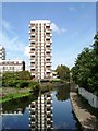
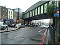
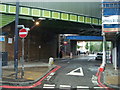
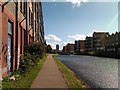
Tower Hamlets is a built-up area in east London covering 18.7 km², home to 218,018 residents. With a population density of 11,681 people per square kilometre, it is one of the most densely populated places in England. The area’s character is shaped by its proximity to London City Airport and its integration into the city’s transport network. Daily life here is defined by urban convenience, with a mix of residential, commercial, and industrial spaces. The median age of 70 suggests a community skewed towards older residents, though the area remains a hub for commuters and workers. Tower Hamlets is served by multiple rail and metro stations, including Limehouse and Canary Wharf, offering easy access to central London. Its compact size means amenities are within walking distance for many, though the high density can create a sense of busyness. The area’s distinctiveness lies in its blend of historic architecture and modern infrastructure, alongside a transport network that connects it to the wider capital. For those considering living here, the challenge is balancing urban vibrancy with the realities of high population density.
- Area Type
- Built Up Area 250
- Area Size
- 18.7 km²
- Population
- 218018
- Population Density
- 11681 people/km²
Living in Tower Hamlets offers access to a range of amenities within easy reach. Retail options include major supermarkets like Tesco Limehouse, Lidl Bow, and Sainsburys Limehouse, ensuring daily shopping needs are met. The area’s transport links connect residents to nearby leisure and cultural hubs, though specific parks or recreational spaces are not detailed in the data. Ferries from Wapping Pier and Canary Wharf Pier provide access to the Thames, while rail stations like Shadwell and Canary Wharf offer proximity to London’s financial district. The presence of London City Airport adds to the area’s connectivity, though it may also bring noise or traffic concerns. For dining and entertainment, the data does not list specific venues, but the density of retail and transport options suggests a vibrant, though compact, urban lifestyle. The mix of retail, transport, and proximity to the airport makes Tower Hamlets convenient for those prioritising accessibility over expansive green spaces.
Amenities
Schools
The schools near Tower Hamlets include a mix of nursery schools and one independent institution. River House Montessori School, an independent school, has an Ofsted rating of inadequate, which may raise concerns for parents seeking high-quality education. Other nearby schools include Children’s House Nursery School, Elizabeth Landsbury Nursery School, Columbia Market Nursery School, and Old Church Nursery School, all of which are nurseries without specified Ofsted ratings. The absence of comprehensive data on school performance means it is difficult to assess the quality of education available. Families with young children may need to look beyond Tower Hamlets for more highly rated schools, as the area’s options are limited. The mix of nursery schools suggests a focus on early education, but the lack of secondary schools or higher-rated institutions could be a drawback for those prioritising long-term educational opportunities.
| Rank | A + A* % | School | Type | Entry gender | Ages |
|---|---|---|---|---|---|
| 1 | N/A | River House Montessori School | independent | N/A | N/A |
| 2 | N/A | Childrens House Nursery School | nursery | N/A | N/A |
| 3 | N/A | Elizabeth Landsbury Nursery School | nursery | N/A | N/A |
| 4 | N/A | Columbia Market Nursery School | nursery | N/A | N/A |
| 5 | N/A | Old Church Nursery School | nursery | N/A | N/A |
Explore more schools in this area
Go to Schools tabDemographics
The population of Tower Hamlets has a median age of 70, indicating a community where older residents predominate. Home ownership is low, with only 25% of households owning their homes, suggesting a rental market dominates. This statistic reflects the area’s role as a place of temporary residence for workers and students, rather than long-term homeownership. The data does not specify household composition or accommodation types, but the high population density implies a mix of shared housing and smaller dwellings. The area’s demographic profile is further shaped by its proximity to London’s financial district, attracting a transient workforce. While the data does not provide details on ethnic or religious diversity, the high density and transport connectivity suggest a cosmopolitan mix. However, the lack of specific figures on deprivation means it is difficult to assess how this affects quality of life. The age profile, combined with the low home ownership rate, points to a community that may require tailored services for older residents and renters.
Household Size
Accommodation Type
Tenure
Ethnic Group
Religion
Household Composition
Age
Household Deprivation
NS-SEC
Explore more demographic insights in this area
Go to Demographics tabPlanning
Planning Constraints
- Crime RiskLocked