Area Overview for Golborne Ward
Photos of Golborne Ward


Area Information
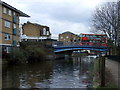
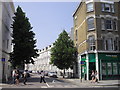
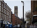
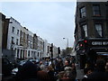
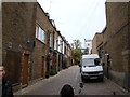
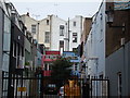
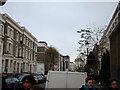
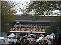
Golborne Ward is an electoral ward within the Royal Borough of Kensington and Chelsea, covering a total area of 55.8 hectares. You will find this district nestled in urban London, encompassing significant landmarks such as Trellick Tower and the Grand Union Canal. The ward includes Golborne Road, a major thoroughfare running from Portobello Road to Kensal Road, which features shops and dining options. This area combines high-density residential living with accessible transport links, situated north of Notting Hill and parallel to the Westway. Living in Golborne Ward means navigating a compact urban environment with a population of 1,428 residents recorded for current analysis, though historical census figures for the broader ward suggest a larger community context around 8,803 people. The terrain is characterised by high-rise developments and diverse neighbourhood streets. As you explore homes in Golborne Ward, you will encounter a mix of accommodation types set against a backdrop of established infrastructure. The location offers proximity to Westbourne Park and Ladbroke Grove Underground stations, alongside train lines near the Grand Union Canal. Your daily routine will benefit from excellent digital connectivity and varied local amenities, making it a distinct choice for those seeking urban living in this specific borough unitary ward.
- Area Type
- District Borough Unitary Ward
- Area Size
- 55.8 hectares
- Population
- 1428
- Population Density
- 2558 people/km²
Demographics
The community in Golborne Ward presents a defined demographic profile, with a median age of 70 years. This indicates a neighbourhood where a significant portion of the population consists of older residents. While the most common age range is listed simply as 'Age: Total', the elevated median figure suggests a steady, mature neighbourhood character. Household composition and ethnicity data are recorded under broad categories without specific statistical breakdowns provided for these fields, meaning the social fabric is represented by the total population metrics available. Home ownership stands at exactly 13% within this ward. This low percentage implies that the vast majority of residents, approximately 87%, do not own their homes outright and likely reside in the private or social rental sectors. You should expect a high volume of renters rather than owner-occupiers when browsing flats or houses in Golborne Ward. The ward covers an area size of 55.8 hectares, supporting a population density of 2,558 people per square kilometre. This high density reinforces the character of the estate as a tightly packed urban environment where communal living is the norm. Accommodation types span the total spectrum available, catering primarily to those seeking rental options close to central London amenities.
Household Size
Accommodation Type
Tenure
Ethnic Group
Religion
Household Composition
Age
Household Deprivation
NS-SEC
Explore more demographic insights in this area
Go to Demographics tabPlanning
Planning Constraints
- Flood RiskPremium
- Ramsar Wetland SitesPremium
- Area of Outstanding Natural BeautyPremium
- Protected Nature ReservePremium
- Protected WoodlandPremium