Area Overview for Erith Ward
Photos of Erith Ward


Area Information
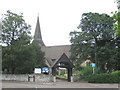
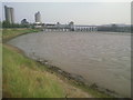
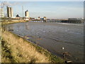
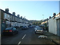
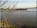
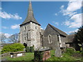
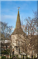
Living in Erith Ward offers a distinct experience set within the London Borough of Bexley. This electoral ward covers a small footprint of 3.2 km² but holds a population of 2,423 residents. The area sits on the south bank of the River Thames in the DA17 postcode district, forming part of the historic town that originated as a Saxon settlement. Its name translates to a muddy harbour or gravelly landing place, reflecting its origins as a riverside community first mentioned in a 695 Latin charter. Today, the ward operates as a unitary ward established for 1978 elections and elects two councillors. The town centre underwent significant redevelopment between 1966 and 1980 to address historical access issues. You will find the area enriched by former industrial sites, including a Henry VIII naval dockyard now known as Riverside Gardens. The White Hart pub and St John's Church remain prominent landmarks in West Street and the High Street. This blend of maritime history and modern connectivity defines daily life for the local population.
- Area Type
- District Borough Unitary Ward
- Area Size
- 3.2 km²
- Population
- 2423
- Population Density
- 751 people/km²
Demographics
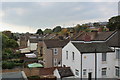
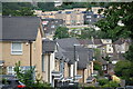
The community in Erith Ward reflects a mature and established demographic profile. The median age for residents is 70 years old, indicating a predominantly elderly population. While the provided data lists Age: Total as the most common age range group, the high median suggests a steady retirement demographic. More than half of the residents own their homes, with a home ownership rate of 52%. This figure indicates a stable community where long-term settling is common rather than transient living. The ward contains a total number of households and uses total accommodation types, suggesting a mix of housing suitable for various family structures. Regarding diversity, the data notes the total predominant ethnic group and total religion without specifying percentages. This lack of granular breakdown means the specific makeup remains broad. Living here means joining a community defined by stability and age rather than rapid demographic shifts or young professional influxes.
Household Size
Accommodation Type
Tenure
Ethnic Group
Religion
Household Composition
Age
Household Deprivation
NS-SEC
Explore more demographic insights in this area
Go to Demographics tabPlanning
Planning Constraints
- Flood RiskPremium
- Ramsar Wetland SitesPremium
- Area of Outstanding Natural BeautyPremium
- Protected Nature ReservePremium
- Protected WoodlandPremium
- Crime RiskPremium