Area Overview for EC2M 4NJ
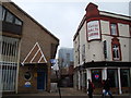
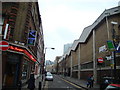
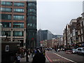
Photos of EC2M 4NJ


Area Information
EC2M 4NJ is a compact residential postcode in central London, home to 1,619 people in a densely populated area of 984 people per square kilometre. This small cluster sits at the heart of a bustling urban environment, where proximity to major transport hubs and commercial centres defines daily life. Residents benefit from immediate access to London’s financial district, historic landmarks, and a network of transport links that make commuting effortless. The area’s character is shaped by its mix of residential flats and proximity to retail, dining, and cultural amenities. While the population is relatively small, the density ensures a lively, interconnected community. With a median age of 47 and a majority of residents aged 30–64, the area is home to a mature demographic, often professionals or families seeking convenience. Living here means embracing a fast-paced lifestyle, where the vibrancy of London’s core meets the practicality of a compact, well-served postcode.
- Area Type
- Postcode
- Area Size
- Not available
- Population
- 1619
- Population Density
- 984 people/km²
The property market in EC2M 4NJ is dominated by rental flats, with only 25% of residents owning their homes. This suggests a strong tenant-focused market, where ownership is not the norm. The area’s small size and high density mean that housing stock is limited, with flats being the primary accommodation type. For buyers, this presents challenges: the scarcity of owner-occupied properties may mean competition for available homes, and the immediate surroundings likely share similar characteristics. The compact nature of the postcode also means that property choices are constrained, with little scope for expansion or development. Investors or homebuyers should consider the area’s rental potential, though the low ownership rate indicates a market where long-term residency is more common than purchase. The focus on flats may appeal to those prioritising convenience over space, but buyers should be prepared for a limited selection of properties.
House Prices in EC2M 4NJ
No properties found in this postcode.
Energy Efficiency in EC2M 4NJ
Living in EC2M 4NJ grants access to a wealth of amenities within walking distance. Retail options include Tesco Bishopsgate and M&S Liverpool St, while transport hubs like Liverpool Street Station and Victoria Coach Station provide connectivity to the wider city. The area’s proximity to London City Airport and ferry terminals adds to its convenience for travel. For leisure, the nearby Fashion Retail Academy and cultural landmarks offer opportunities for learning and exploration. The compact layout ensures that essential services are never far, though the limited space means the area’s character is defined by its density rather than expansive parks or open spaces. Residents benefit from a lifestyle that balances urban convenience with the need for efficient, compact living.
Amenities
Schools
The schools near EC2M 4NJ include The Aldgate School, a primary school with an outstanding Ofsted rating, and St Paul’s Cathedral School, which is independent. Nearby are City of London School, another independent institution, and David Game College, an independent college with an outstanding rating. The Fashion Retail Academy is listed as an other-type school. This mix of state and independent education options provides families with flexibility, whether they seek affordable state schooling or the resources of private institutions. The presence of two outstanding-rated schools, particularly at primary and post-secondary levels, is a significant advantage for parents prioritising academic quality. However, the area’s small size means that school catchment areas and availability may be limited, requiring careful research for families with specific needs.
| Rank | School | Type | Entry gender | Ages |
|---|
Explore more schools in this area
Go to Schools tabDemographics
The community in EC2M 4NJ is predominantly composed of adults aged 30–64, with a median age of 47. This suggests a population skewed toward middle-aged individuals, likely professionals or established families. Home ownership is low, with only 25% of residents owning their homes, indicating a rental-dominated market. The accommodation type is primarily flats, reflecting the area’s compact nature and urban setting. The predominant ethnic group is White, though the data does not provide further breakdowns of diversity. The low home ownership rate and high proportion of adults imply a transient or rental-focused population, possibly drawn by the area’s proximity to employment opportunities and transport. While the data does not include deprivation metrics, the combination of high population density and limited home ownership could suggest a mix of economic profiles, from higher-income professionals to those in more modest circumstances.
Household Size
Accommodation Type
Tenure
Ethnic Group
Religion
Household Composition
Age
Household Deprivation
NS-SEC
Explore more demographic insights in this area
Go to Demographics tabPlanning
Planning Constraints
- Flood RiskPremium
- Ramsar Wetland SitesPremium
- Area of Outstanding Natural BeautyPremium
- Protected Nature ReservePremium
- Protected WoodlandPremium