Area Overview for EC1V 9FQ
Photos of EC1V 9FQ


Area Information
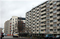
EC1V 9FQ is a small residential cluster in central London, home to 2,356 people. Its compact size means it is densely populated yet offers proximity to key urban amenities. The area is defined by its mix of modern and older infrastructure, with a focus on convenience for those prioritising accessibility over space. Daily life here is shaped by its location, with nearby transport hubs, retail outlets, and educational institutions within easy reach. The postcode’s character is influenced by its proximity to the City of London and Shoreditch, blending professional and creative energies. While the area is small, it is well-connected, making it suitable for commuters or those seeking a central base. The population, predominantly adults aged 30–64, suggests a community of professionals and families, though the low home ownership rate indicates a reliance on rental properties. Living here means navigating a dynamic urban environment with limited green spaces but ample cultural and economic opportunities.
- Area Type
- Postcode
- Area Size
- Not available
- Population
- Not available
- Population Density
- Not available
EC1V 9FQ is predominantly a rental market, with 22% of homes owned by residents. The accommodation type is almost exclusively flats, reflecting the area’s compact nature and urban setting. This suggests limited availability of larger properties or detached homes, which may deter buyers seeking more space. The small residential cluster means the housing stock is concentrated, with little scope for expansion. For buyers, this could pose challenges, as the area’s size restricts options, and the high proportion of rentals may indicate competitive demand. The focus on flats also aligns with London’s broader trend of high-density living, though it may not suit those prioritising private outdoor space. Prospective buyers should consider the area’s proximity to transport and amenities as key advantages, even if property diversity is limited.
House Prices in EC1V 9FQ
No properties found in this postcode.
Energy Efficiency in EC1V 9FQ
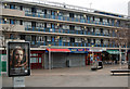
Residents of EC1V 9FQ have access to a range of amenities within practical reach. Retail options include Sainsburys Shoreditch, Sainsburys London, and Aldi Old, providing everyday shopping needs. The area’s transport links also grant access to major hubs like London Victoria Coach Station and Green Line Coach Station, enhancing connectivity for travel. While the data does not mention parks or leisure facilities, the proximity to the City of London and Shoreditch suggests a vibrant cultural scene with galleries, restaurants, and nightlife. The density of retail, transport, and educational services indicates a lifestyle focused on convenience and accessibility, though green spaces may be limited. The area’s character is defined by its role as a central node, prioritising urban living over rural tranquillity.
Amenities
Schools
The area is served by three primary schools, including Moorfields Primary School, Prior Weston Primary School and Children’s Centre (rated ‘good’ by Ofsted), and Central Foundation Boys’ School (rated ‘outstanding’). These institutions cater to young families, with a mix of state-funded options. The presence of an ‘outstanding’ school suggests high educational standards in the vicinity, while the ‘good’ rating at Prior Weston indicates reliable, if not exceptional, provision. The absence of secondary schools nearby means families may need to look further afield for secondary education, but the primary options available are sufficient for early years. The concentration of schools reflects the area’s role as a family-friendly zone, though the lack of higher education facilities is a practical consideration for long-term residents.
| Rank | School | Type | Entry gender | Ages |
|---|
Explore more schools in this area
Go to Schools tabDemographics
The population of EC1V 9FQ is 2,356, with a median age of 47, reflecting a mature demographic skewed toward adults aged 30–64. Home ownership is low, at just 22%, suggesting most residents are renters, likely due to the area’s focus on flats rather than detached housing. The predominant ethnic group is White, though the data does not specify further diversity metrics. The age profile indicates a community of established professionals and families, with fewer young people or retirees. This demographic may influence local services and amenities, which cater more to working-age adults. The absence of specific deprivation data means quality of life factors like access to healthcare or leisure remain unquantified, but the area’s connectivity and proximity to services suggest a generally functional environment for its residents.
Household Size
Accommodation Type
Tenure
Ethnic Group
Religion
Household Composition
Age
Household Deprivation
NS-SEC
Explore more demographic insights in this area
Go to Demographics tabPlanning
Planning Constraints
- Flood RiskPremium
- Ramsar Wetland SitesPremium
- Area of Outstanding Natural BeautyPremium
- Protected Nature ReservePremium
- Protected WoodlandPremium