Area Overview for E9 5RJ
Photos of E9 5RJ
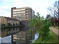
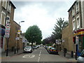
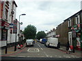
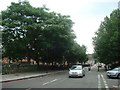
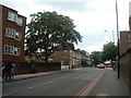


100 photos from this area
Area Information
Key information about the E9 5RJ including its size, population, and administrative classification.
- Area Type
- Postcode
- Area Size
- 5133 m²
- Population
- 1332
- Population Density
- 12602 people/km²
House Prices in E9 5RJ
14
Properties
£182,000
Average Sold Price
£70,000
Lowest Price
£450,000
Highest Price
Showing 14 properties
| Address | Type | Beds | Baths | Last Sale Price | Last Sale Date | |
|---|---|---|---|---|---|---|
| 77 Mabley Street, Hackney, London, E9 5RJ | Terraced | 4 | 1 | £450,000 | Apr 2017 | |
| 73 Mabley Street, Hackney, London, E9 5RJ | house | - | - | £249,995 | Jun 2007 | |
| 85 Mabley Street, Hackney, London, E9 5RJ | house | 3 | - | £225,000 | Apr 2006 | |
| 75 Mabley Street, Hackney, London, E9 5RJ | house | - | - | £200,000 | Oct 2004 | |
| 83 Mabley Street, Hackney, London, E9 5RJ | house | - | - | £213,000 | Mar 2004 | |
| 93 Mabley Street, Hackney, London, E9 5RJ | Terraced | - | - | £70,000 | Aug 2002 | |
| 71 Mabley Street, Hackney, London, E9 5RJ | Semi-detached | 3 | 1 | £144,000 | Jun 2001 | |
| 91 Mabley Street, Hackney, London, E9 5RJ | Terraced | - | - | £122,000 | Apr 2000 | |
| 95 Mabley Street, Hackney, London, E9 5RJ | house | - | - | £75,000 | Mar 1999 | |
| 69 Mabley Street, Hackney, London, E9 5RJ | house | - | - | £71,000 | Mar 1998 |
Page 1 of 2
Energy Efficiency in E9 5RJ
Amenities
Schools
| Rank | School | Type | Entry gender | Ages |
|---|
Explore more schools in this area
Go to Schools tabDemographics
Household Size
Two person
most common
Accommodation Type
Flats
most common
Tenure
24
majority
Ethnic Group
White
most common
Religion
N/A
most common
Household Composition
N/A
most common
Age
47
median
Adults (30-64 years)
most common
Household Deprivation
N/A
with no deprivation
NS-SEC
39
in Lower managerial occupations
Explore more demographic insights in this area
Go to Demographics tabPlanning
Planning Constraints
- Flood RiskPremium
- Ramsar Wetland SitesPremium
- Area of Outstanding Natural BeautyPremium
- Protected Nature ReservePremium
- Protected WoodlandPremium