Area Overview for E6 6AZ
Photos of E6 6AZ
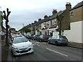
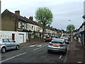
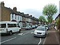
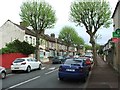
75 photos from this area
Area Information
Key information about the E6 6AZ including its size, population, and administrative classification.
- Area Type
- Postcode
- Area Size
- 1.3 hectares
- Population
- 1856
- Population Density
- 3729 people/km²
House Prices in E6 6AZ
60
Properties
£203,818
Average Sold Price
£24,000
Lowest Price
£530,000
Highest Price
Showing 60 properties
| Address | Type | Beds | Baths | Last Sale Price | Last Sale Date | |
|---|---|---|---|---|---|---|
| 159 Folkestone Road, East Ham, London, E6 6AZ | house | - | - | £530,000 | Jul 2021 | |
| 125 Folkestone Road, East Ham, London, E6 6AZ | house | - | - | £432,000 | Aug 2020 | |
| 103 Folkestone Road, East Ham, London, E6 6AZ | Flat | - | - | £310,000 | Nov 2019 | |
| 85 Folkestone Road, East Ham, London, E6 6AZ | Flat | - | - | £320,000 | Oct 2019 | |
| 73 Folkestone Road, East Ham, London, E6 6AZ | Flat | - | - | £325,000 | Dec 2018 | |
| 151 Folkestone Road, East Ham, London, E6 6AZ | Flat | - | - | £195,000 | Jun 2016 | |
| 79 Folkestone Road, East Ham, London, E6 6AZ | Flat | - | - | £171,000 | Apr 2014 | |
| 105 Folkestone Road, East Ham, London, E6 6AZ | Flat | - | - | £160,000 | Apr 2012 | |
| 165 Folkestone Road, East Ham, London, E6 6AZ | Terraced | - | - | £262,000 | Aug 2008 | |
| 117 Folkestone Road, East Ham, London, E6 6AZ | house | - | - | £227,000 | Apr 2008 |
Page 1 of 6
Energy Efficiency in E6 6AZ
Amenities
Schools
| Rank | School | Type | Entry gender | Ages |
|---|
Explore more schools in this area
Go to Schools tabDemographics
Household Size
Family (3-5 people)
most common
Accommodation Type
Flats
most common
Tenure
25
majority
Ethnic Group
asian_total
most common
Religion
N/A
most common
Household Composition
N/A
most common
Age
47
median
Adults (30-64 years)
most common
Household Deprivation
N/A
with no deprivation
NS-SEC
16
in Lower managerial occupations
Explore more demographic insights in this area
Go to Demographics tabPlanning
Planning Constraints
- Flood RiskPremium
- Ramsar Wetland SitesPremium
- Area of Outstanding Natural BeautyPremium
- Protected Nature ReservePremium
- Protected WoodlandPremium