Area Overview for E5 9SW
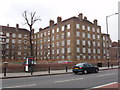
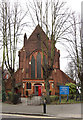
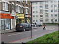
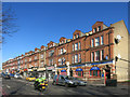
Photos of E5 9SW


Area Information
E5 9SW is a small residential cluster in England, home to 1,933 people. The area’s compact size means it is likely a tight-knit community, with residents living in proximity to local amenities and transport links. The median age of 47 suggests a mature population, with most residents in the 30-64 age range. This demographic profile indicates a mix of professionals, families, and retirees, though the exact composition of household types is not specified. Daily life here is shaped by its connectivity to broader London networks, with multiple rail, metro, and bus services within reach. The area’s proximity to major transport hubs, including London City Airport and several underground stations, makes it a practical choice for commuters. However, its small scale means it is not a high-density urban area, offering a quieter alternative to larger parts of the city. The lack of significant natural or protected sites nearby suggests a focus on residential living rather than tourism or conservation. For those seeking a balance between accessibility and a manageable community size, E5 9SW could be a viable option.
- Area Type
- Postcode
- Area Size
- Not available
- Population
- 1933
- Population Density
- 11033 people/km²
The property market in E5 9SW is defined by a 44% home ownership rate, with houses being the predominant accommodation type. This contrasts with areas where flats or apartments dominate, suggesting a more traditional housing stock. The lower home ownership figure implies that a larger share of the market is rental-based, which could influence property values and availability. The presence of houses rather than high-density housing may appeal to families or those seeking more space, but the small population size of 1,933 means the market is limited in scale. Buyers should consider that the area’s compact nature may restrict the number of properties available, and its proximity to transport links could make it attractive to commuters. However, the lack of specific data on property prices or recent transactions means potential buyers must conduct further research into local listings and market trends.
House Prices in E5 9SW
No properties found in this postcode.
Energy Efficiency in E5 9SW
Residents of E5 9SW have access to a range of amenities within practical reach. Retail options include major stores like Tesco Hackney and Co-op Hackney, offering everyday shopping needs. The area’s proximity to multiple rail, metro, and bus services, including Rectory Road Station and Whipps Cross Bus Interchange, ensures convenient travel for work, leisure, or commuting. Nearby ferry services at Tower Pier and London Bridge City Pier provide alternative transport routes, while London City Airport is a short distance away. Although specific parks or leisure facilities are not detailed in the data, the presence of multiple transport hubs suggests the area is well-integrated into London’s broader networks. This connectivity supports a lifestyle that combines local convenience with access to the city’s cultural, commercial, and recreational opportunities, though the small scale of the area may limit on-site amenities.
Amenities
Schools
| Rank | School | Type | Entry gender | Ages |
|---|
Explore more schools in this area
Go to Schools tabDemographics
The population of E5 9SW has a median age of 47, with the majority of residents falling within the 30-64 age range. This suggests a community of working-age adults and older individuals, but no data is available on the proportion of retirees or younger families. Home ownership stands at 44%, which is below the national average, indicating that a significant portion of the housing stock is rented. The predominant accommodation type is houses, which is uncommon in many urban areas, hinting at a more suburban or semi-rural character. The predominant ethnic group is White, though no specific figures are provided for other ethnicities. This data does not indicate levels of deprivation or socioeconomic diversity, but the lower home ownership rate could suggest a mix of rental properties and owner-occupied homes. The absence of detailed demographic breakdowns means the community’s full composition remains unclear, but the age profile and housing type suggest a stable, settled population.
Household Size
Accommodation Type
Tenure
Ethnic Group
Religion
Household Composition
Age
Household Deprivation
NS-SEC
Explore more demographic insights in this area
Go to Demographics tabPlanning
Planning Constraints
- Flood RiskPremium
- Ramsar Wetland SitesPremium
- Area of Outstanding Natural BeautyPremium
- Protected Nature ReservePremium
- Protected WoodlandPremium